METAR & TAF C98
C98 does not publish a METAR.
Showing the nearest reporting station: KRZL (JASPER COUNTY) · 17.6 NM away. Conditions at C98 may differ.
METAR · KRZL
Observed 16:35Z
KRZL 261635Z AUTO 23004KT 10SM BKN031 BKN037 27/22 A2996 RMK AO2
- Wind
- 230° @ 4 kt
- Visibility
- 10 SM
- Temp / Dew
- 27°C / 22°C
- Altimeter
- 29.96 inHg
- Clouds
- BKN
- Density alt
- 2,189 ft
- Ceiling
- 3,100 ft AGL
- Rules
- VFR
Airport info & contacts
Manager on record, flight service, ARTCC, attendance schedule and pattern altitude — published by the FAA and refreshed every 28 days.
Location
- From city
- 1 NM NW
- VFR sectional
- CHICAGO
- ARTCC
- ZAU · CHICAGO
- NOTAM facility
- HUF (NOTAM-D)
Airport manager
- Name
- MICHAEL STEINLE
- Phone
- 219-992-9200
- Address
- 3644 W. STATE ROAD 10, LAKE VILLAGE IN 46349
Flight service · Hours
- FSS HUF
- TERRE HAUTE1-800-WX-BRIEF
- Attendance
- SR-SS
Frequencies
Tap any row to copy the frequency to your clipboard.
Runways & pattern
Full pagePattern entry · RWY 18
LEFT TRAFFICRunway end performance
| End | TORA | TODA | ASDA | LDA | VGSI | Approach lights | Obstruction |
|---|---|---|---|---|---|---|---|
| 18 | — | — | — | — | — | — | 10', road, 250' from thr, 0' R of cntrln, slope 25 |
| 36 | — | — | — | — | — | — | 15', road, 320' from thr, 0' R of cntrln, slope 21 |
Declared distances in feet. TORA = takeoff run available, TODA = takeoff distance, ASDA = accelerate-stop, LDA = landing distance.
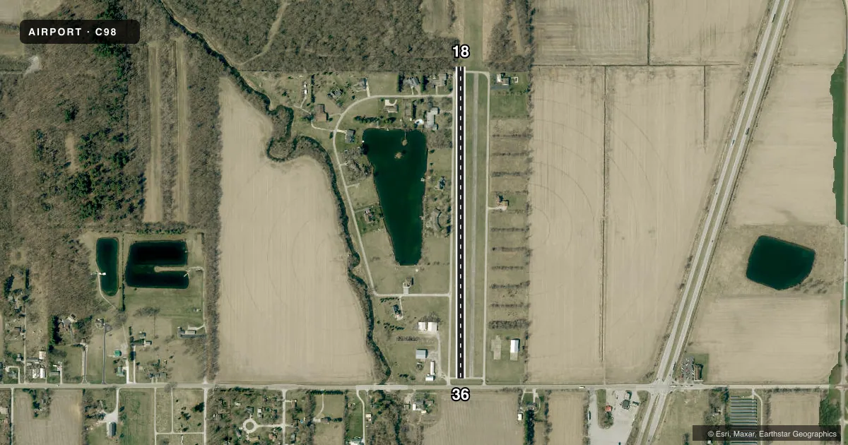
Airport sketch
Runways drawn to scale from FAA survey coordinates, rendered over satellite imagery. Not for navigation.
Approaches & charts
Services on the field
Fuel grades, oxygen, maintenance, ramp storage and lighting — as declared to the FAA by the airport operator.
Fuel & services
- Fuel
- Not available
- Airframe repair
- Major
- Power plant repair
- Major
Ramp & ground
- Transient storage
- Tie-down
- Landing fee
- No fee published
- Customs
- Not available
- Wind indicator
- Yes
- Segmented circle
- No
Fuel & FBOs
Cheapest 100LL and Jet A on the field and nearby. Always confirm with the FBO before taxi.
Airport notes
Surface conditions, obstructions, local procedures, lighting outages and other notes published with each FAA cycle.
General notes
- VEHICLES ON ROAD SRNDG RWY.
- DEER ON & INVOF ARPT.
- FOR CD CTC CHICAGO ARTCC AT 630-906-8921.
Runway surface & condition
- 18/36MID 38 FT ASPH.
Approach & departure obstructions
- 183 YELLOW TIRES/LGTS EACH SIDE.
- 363 YELLOW TIRES/LGTS EACH SIDE.
Other notes
- EXISTED PRIOR TO 1959.
VFR map & nearby airports
VFR sectional. Tap any ICAO chip to open that airport.
Key facts · C98
Answer card- ICAO
- C98
- Name
- LAKE VILLAGE
- Location
- LAKE VILLAGE, INDIANA
- Elevation
- 644 ft MSL
- Traffic pattern altitude
- 1,644 ft MSL (1,000 AGL)
- Control tower
- Non-towered (use CTAF)
- Total runways
- 1
- Longest runway
- 18/36 · 2,000 ft
- Published ILS approaches
- 0
- Published frequencies
- 1
- Magnetic variation
- 1°
- Current flight rules
- VFR
- Current wind
- 230° at 4 kt
- Favored runway now
- RWY 18
Lake Village Airport (C98) is in Lake Village, Indiana. The field elevation is 644 ft MSL. It has one runway, 18/36, which is 2,000 ft long and turf. The middle 38 feet of the runway is asphalt. Runway 18 and Runway 36 both have three yellow tires and lights on each side. This airport is uncontrolled. CTAF is 122.9. No ILS approaches are published.
Pattern altitude is not published. Use 1,000 ft AGL for light piston operations unless the current Chart Supplement says otherwise. Deer are on and in the vicinity of the airport. Vehicles are on roads surrounding the runway, so keep your scan tight on base and final. Clearance delivery, if needed, is handled through Chicago ARTCC at 630-906-8921. There are no on-field FBOs listed here, so verify fuel and services with the airport operator or call the field directly before you go. The runway layout and turf surface make this a simple airport to read. The surrounding traffic and wildlife mean you should plan a careful arrival and departure.