METAR & TAF KRZL
Current METAR
Observed 12:35Z
KRZL 271235Z AUTO 00000KT 3SM BR BKN003 OVC007 22/22 A2991 RMK AO2
- Wind
- 000° @ 0 kt
- Visibility
- 3 SM
- Temp / Dew
- 22°C / 22°C
- Altimeter
- 29.91 inHg
- Clouds
- OVC
- Density alt
- 1,718 ft
- Ceiling
- 300 ft AGL
- Rules
- LIFR
Airport info & contacts
Manager on record, flight service, ARTCC, attendance schedule and pattern altitude — published by the FAA and refreshed every 28 days.
Location
- From city
- 1 NM NW
- VFR sectional
- CHICAGO
- ARTCC
- ZAU · CHICAGO
- NOTAM facility
- HUF (NOTAM-D)
Airport manager
- Name
- EMILY HACKLER
- Phone
- 219-866-2100
- Address
- 2326 W. CLARK ST., RENSSELAER IN 47978
Flight service · Hours
- FSS HUF
- TERRE HAUTE1-800-WX-BRIEF
- Attendance
- MON-FRI · 0800-1700
Frequencies
Tap any row to copy the frequency to your clipboard.
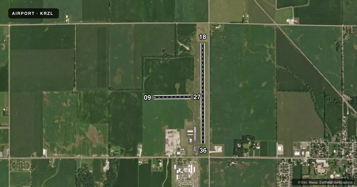
Runways & pattern
Full pagePattern entry · RWY 18
LEFT TRAFFIC| Runway | Heading (°M) | Length | Surface | Traffic |
|---|---|---|---|---|
| 18/36 | 178° / 358° | 4,000 ft | CONC | Standard L |
| 09/27 | 87° / 267° | 1,450 ft | TURF | Standard L |
Runway end performance
| End | TORA | TODA | ASDA | LDA | VGSI | Approach lights | Obstruction |
|---|---|---|---|---|---|---|---|
| 18 | — | — | — | — | PAPI 2-box left(3°) | — | 29', road, 790' from thr, 0' R of cntrln, slope 20 |
| 36 | — | — | — | — | PAPI 2-box left(3°) | — | 15', road, 520' from thr, 0' R of cntrln, slope 21 |
Declared distances in feet. TORA = takeoff run available, TODA = takeoff distance, ASDA = accelerate-stop, LDA = landing distance.
Airport sketch
Runways drawn to scale from FAA survey coordinates, rendered over satellite imagery. Not for navigation.
Approaches & charts
Services on the field
Fuel grades, oxygen, maintenance, ramp storage and lighting — as declared to the FAA by the airport operator.
Fuel & services
- Fuel
- 100LLA+
- Airframe repair
- Major
- Power plant repair
- Major
- Other services
- INSTR,RNTL
Ramp & ground
- Transient storage
- Tie-down
- Hangar
- Landing fee
- No fee published
- Customs
- Not available
- Lighting schedule
- SEE RMK
- Beacon schedule
- SS-SR
- Beacon
- White / Green (civil land)(WG)
- Wind indicator
- Lighted
- Segmented circle
- No
Fuel & FBOs
Cheapest 100LL and Jet A on the field and nearby. Always confirm with the FBO before taxi.
Airport notes
Surface conditions, obstructions, local procedures, lighting outages and other notes published with each FAA cycle.
General notes
- COND UNMNT 1700-0800.
- FOR CD CTC CHICAGO ARTCC AT 630-906-8921.
Lighting notes
- ACTVT REIL RWY 18 & 36; MIRL RWY 18/36 - CTAF. PAPI RWY 18 & 36 ON CONSLY.
Fuel notes
- 100LLSELF SVC FUEL H24 WITH CREDIT CARD.
Approach & departure obstructions
- 36CROPS 120 FT R OF CNTRLN AT THR; ROAD 245 FT R OF CNTRLN. TIE-DOWN AREA 100 FT FM RWY END 130 FT L OF CNTRLN.
- 09ORANGE CONES.
- 27ORANGE CONES.
- 27APCH SLOPE 35:1 TO DTHR.
Other notes
- MANAGER219-869-5103.
VFR map & nearby airports
VFR sectional. Tap any ICAO chip to open that airport.
Key facts · KRZL
Answer card- ICAO
- KRZL
- Name
- JASPER COUNTY
- Location
- RENSSELAER, INDIANA
- Elevation
- 698.3 ft MSL
- Traffic pattern altitude
- 1,698.3 ft MSL (1,000 AGL)
- Control tower
- Non-towered (use CTAF)
- Total runways
- 2
- Longest runway
- 18/36 · 4,000 ft
- Published ILS approaches
- 0
- Published frequencies
- 2
- Magnetic variation
- 2°
- Current flight rules
- LIFR
- Current wind
- 000° at 0 kt
- Favored runway now
- –
Jasper County Airport (KRZL) sits in Rensselaer, Indiana. Field elevation is 698.3 ft MSL. The airport has two runways. The longest is 18/36 at 4,000 ft of concrete. Runway 09/27 is 1,450 ft of turf. There is no control tower. CTAF and UNICOM are both 122.8. No ILS approaches are published here.
Pattern altitude is not published. Use the standard 1,000 ft AGL for light piston traffic unless local procedures say otherwise. That puts the pattern at about 1,698 ft MSL based on the field elevation. Verify before you fly. The on-field FBO is Jasper County Airport Authority. It carries AVGAS_100LL and JET_A_PRIST. Self-service 100LL is available 24 hours with a credit card.
A few runway notes matter here. Orange cones mark runway 09 and runway 27. Runway 18 and runway 36 have medium intensity lighting, runway end identifier lights and PAPI that stays on continuously. Runway 27 has a displaced threshold with a 35 to 1 approach slope. There are crops and a road off the right side near the runway 36 threshold. The airport is unmonitored from 1700 to 0800. If you need clearance delivery, contact Chicago ARTCC. For a first-time arrival, plan the non-towered pattern carefully. Verify the current Chart Supplement for any local remarks before departure.