METAR & TAF KMCX
Current METAR
Observed 11:35Z
KMCX 271135Z AUTO 00000KT 1/4SM FG OVC002 22/22 A2991 RMK AO2 T02240216
- Wind
- 000° @ 0 kt
- Visibility
- 0.25 SM
- Temp / Dew
- 22°C / 22°C
- Altimeter
- 29.91 inHg
- Clouds
- OVC
- Density alt
- 1,694 ft
- Ceiling
- 200 ft AGL
- Rules
- LIFR
Airport info & contacts
Manager on record, flight service, ARTCC, attendance schedule and pattern altitude — published by the FAA and refreshed every 28 days.
Location
- From city
- 3 NM S
- VFR sectional
- CHICAGO
- ARTCC
- ZAU · CHICAGO
- NOTAM facility
- HUF (NOTAM-D)
Airport manager
- Name
- DEREK SHANNON
- Phone
- 574-583-9900
- Address
- 2222 AIRPORT RD, MONTICELLO IN 47960
Flight service · Hours
- FSS HUF
- TERRE HAUTE1-800-WX-BRIEF
- Attendance
- 0800-1600
Frequencies
Tap any row to copy the frequency to your clipboard.
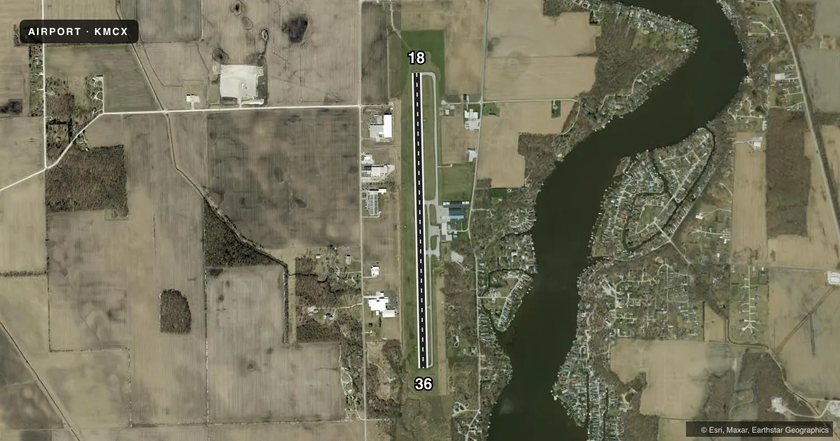
Runways & pattern
Full pagePattern entry · RWY 18
LEFT TRAFFICRunway end performance
| End | TORA | TODA | ASDA | LDA | VGSI | Approach lights | Obstruction |
|---|---|---|---|---|---|---|---|
| 18 | — | — | — | — | PAPI 2-box left(3°) | — | — |
| 36 | — | — | — | — | PAPI 2-box left(4°) | — | 11', fence, 400' from thr, 145' R of cntrln, slope 18 |
Declared distances in feet. TORA = takeoff run available, TODA = takeoff distance, ASDA = accelerate-stop, LDA = landing distance.
Airport sketch
Runways drawn to scale from FAA survey coordinates, rendered over satellite imagery. Not for navigation.
Approaches & charts
Services on the field
Fuel grades, oxygen, maintenance, ramp storage and lighting — as declared to the FAA by the airport operator.
Fuel & services
- Fuel
- 100LLA
- Oxygen (bottled)
- Not available
- Oxygen (bulk)
- Not available
- Airframe repair
- Minor
- Power plant repair
- Minor
- Other services
- AGRI
Ramp & ground
- Transient storage
- Tie-down
- Hangar
- Landing fee
- No fee published
- Customs
- Not available
- Lighting schedule
- SEE RMK
- Beacon schedule
- SS-SR
- Beacon
- White / Green (civil land)(WG)
- Wind indicator
- Lighted
- Segmented circle
- No
Fuel & FBOs
Cheapest 100LL and Jet A on the field and nearby. Always confirm with the FBO before taxi.
Airport notes
Surface conditions, obstructions, local procedures, lighting outages and other notes published with each FAA cycle.
General notes
- TWY EDGE MARKED WITH 2 FT YELLOW CYLINDER REFLECTORS.
- DEER INVOF ARPT.
- FREQUENT AERIAL APPLICATION TFC DUR MONTHS OF JUN, JUL, AUG.
- FOR CD CTC CHICAGO ARTCC AT 630-906-8921.
Lighting notes
- ACTVT REIL RWY 18/36; MIRL 18/36 - CTAF.
Fuel notes
- 100LLSELF SVC AVBL 24 HRS.
- AUNDERWING & OVERWING REFUELING AVAILABLE UPON REQUEST. SELF SVC AVBL 24 HRS.
Approach & departure obstructions
- 18UNUSBL BYD 8 DEGS RIGHT OF CNTRLN.
Other notes
- 1ARPT UNATNDD ALL MAJOR HOLIDAYS.
VFR map & nearby airports
VFR sectional. Tap any ICAO chip to open that airport.
Key facts · KMCX
Answer card- ICAO
- KMCX
- Name
- WHITE COUNTY
- Location
- MONTICELLO, INDIANA
- Elevation
- 678.5 ft MSL
- Traffic pattern altitude
- 1,678.5 ft MSL (1,000 AGL)
- Control tower
- Non-towered (use CTAF)
- Total runways
- 1
- Longest runway
- 18/36 · 5,001 ft
- Published ILS approaches
- 0
- Published frequencies
- 4
- Magnetic variation
- 3°
- Current flight rules
- LIFR
- Current wind
- 000° at 0 kt
- Favored runway now
- –
White County Airport is in Monticello, Indiana. The field elevation is 678.5 ft MSL. It has one runway, 18/36, which is 5,001 ft long and asphalt. There is no control tower. Pattern altitude is not published, so use the standard 1,000 ft AGL for light piston aircraft unless the current Chart Supplement says otherwise.
No ILS approaches are published here. The airport uses CTAF 122.8 and UNICOM 122.8. Runway end identifier lights and medium intensity runway lights on 18/36 are activated via CTAF. MCX Aero is on the field. It carries AVGAS 100LL and Jet A. Self-service fuel is available 24 hours a day. Underwing and overwing refueling are available upon request.
A few remarks matter for planning. Runway 18 is unusable beyond 8 degrees right of the centerline. Deer are in the vicinity of the airport. Frequent aerial application traffic occurs in June, July and August. The airport is unattended on all major holidays. For clearance delivery, contact Chicago ARTCC at 630-906-8921. If you are arriving for the first time, brief the runway alignment carefully. Expect non-towered traffic. Check the current Chart Supplement for any published noise or curfew restrictions before flying into the field.