METAR & TAF I00
I00 does not publish a METAR.
Showing the nearest reporting station: KMCX (WHITE COUNTY) · 5.4 NM away. Conditions at I00 may differ.
METAR · KMCX
Observed 14:35Z
KMCX 251435Z AUTO 00000KT 10SM BKN060 OVC075 20/15 A3007 RMK AO2 T02030147
- Wind
- 000° @ 0 kt
- Visibility
- 10 SM
- Temp / Dew
- 20°C / 15°C
- Altimeter
- 30.07 inHg
- Clouds
- OVC
- Density alt
- 1,226 ft
- Ceiling
- 6,000 ft AGL
- Rules
- VFR
Airport info & contacts
Manager on record, flight service, ARTCC, attendance schedule and pattern altitude — published by the FAA and refreshed every 28 days.
Location
- From city
- 3 NM N
- VFR sectional
- CHICAGO
- ARTCC
- ZAU · CHICAGO
- NOTAM facility
- HUF (NOTAM-D)
Airport manager
- Name
- KENTON TURNER
- Phone
- (317) 232-0935
- Address
- 402 W. WASHINGTON ST., RM W-255D, INDIANAPOLIS IN 46204
Flight service · Hours
- FSS HUF
- TERRE HAUTE1-800-WX-BRIEF
Frequencies
Tap any row to copy the frequency to your clipboard.
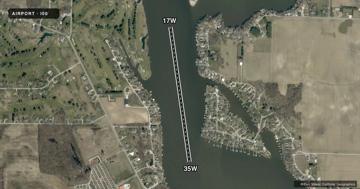
Runways & pattern
Full pagePattern entry · RWY 17W
LEFT TRAFFICAirport sketch
Runways drawn to scale from FAA survey coordinates, rendered over satellite imagery. Not for navigation.
Approaches & charts
Services on the field
Fuel grades, oxygen, maintenance, ramp storage and lighting — as declared to the FAA by the airport operator.
Fuel & services
- Fuel
- Not available
Ramp & ground
- Transient storage
- Not published
Fuel & FBOs
Cheapest 100LL and Jet A on the field and nearby. Always confirm with the FBO before taxi.
Airport notes
Surface conditions, obstructions, local procedures, lighting outages and other notes published with each FAA cycle.
General notes
- SEAPLANE OPS PROHIBITED BETWEEN SS-SR. EXPECT HEAVY BOAT TRAFFIC BETWEEN MEMORIAL DAY AND LABOR DAY. DO NOT BLOCK BOAT RAMPS, SEAPLANE DOCKING AREAS LIMITED.
VFR map & nearby airports
VFR sectional. Tap any ICAO chip to open that airport.
Key facts · I00
Answer card- ICAO
- I00
- Name
- LAKE SHAFER
- Location
- MONTICELLO, INDIANA
- Elevation
- 655 ft MSL
- Traffic pattern altitude
- 1,655 ft MSL (1,000 AGL)
- Control tower
- Non-towered (use CTAF)
- Total runways
- 1
- Longest runway
- 17W/35W · 2,675 ft
- Published ILS approaches
- 0
- Published frequencies
- 1
- Magnetic variation
- –
- Current flight rules
- VFR
- Current wind
- 000° at 0 kt
- Favored runway now
- –
Lake Shafer (I00) sits near Monticello, Indiana. The field elevation is 655 ft MSL. It has one runway. The longest is the 2,675 ft water runway 17W/35W with magnetic headings of 170° and 350°. There is no control tower. CTAF is 122.9.
No ILS approaches are published here. The pattern altitude is not published in the facts, so use the current FAA Chart Supplement before you go. This is a seaplane field, so water traffic matters. Published remarks say seaplane operations are prohibited between sunset and sunrise. Expect heavy boat traffic from Memorial Day through Labor Day. Do not block boat ramps. Docking areas are limited.
There are no on-field FBOs listed in the facts. Contact the airport operator directly before arrival. You can also call the field on CTAF for current service details. For a first-time arrival, plan for a water landing environment with traffic on the lake, limited docking space and no published instrument approach support. Check the current FAA Chart Supplement for any other local procedures before flying in.