METAR & TAF 50I
50I does not publish a METAR.
Showing the nearest reporting station: KRZL (JASPER COUNTY) · 15.9 NM away. Conditions at 50I may differ.
METAR · KRZL
Observed 18:55Z
KRZL 261855Z AUTO 20006KT 10SM SCT034 BKN043 28/22 A2994 RMK AO2
- Wind
- 200° @ 6 kt
- Visibility
- 10 SM
- Temp / Dew
- 28°C / 22°C
- Altimeter
- 29.94 inHg
- Clouds
- BKN
- Density alt
- 2,402 ft
- Ceiling
- 4,300 ft AGL
- Rules
- VFR
Airport info & contacts
Manager on record, flight service, ARTCC, attendance schedule and pattern altitude — published by the FAA and refreshed every 28 days.
Location
- From city
- 1 NM SE
- VFR sectional
- CHICAGO
- ARTCC
- ZAU · CHICAGO
- NOTAM facility
- HUF (NOTAM-D)
Airport manager
- Name
- JIM BUTLER
- Phone
- 219-863-7620
- Address
- 2291E 1635S, KENTLAND IN 47951
Flight service · Hours
- FSS HUF
- TERRE HAUTE1-800-WX-BRIEF
- Attendance
- MON-FRI · 0800-1600
Frequencies
Tap any row to copy the frequency to your clipboard.
Runways & pattern
Full pagePattern entry · RWY 27
LEFT TRAFFICRunway end performance
| End | TORA | TODA | ASDA | LDA | VGSI | Approach lights | Obstruction |
|---|---|---|---|---|---|---|---|
| 09 | — | — | — | — | PAPI 2-box left(3°) | — | 10', crops, 230' from thr, 0' R of cntrln, slope 3 |
| 27 | — | — | — | — | PAPI 2-box left(3°) | — | 10', crops, 201' from thr, 0' R of cntrln, slope 20 |
Declared distances in feet. TORA = takeoff run available, TODA = takeoff distance, ASDA = accelerate-stop, LDA = landing distance.
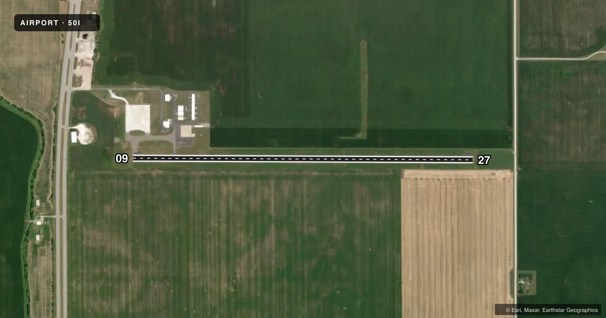
Airport sketch
Runways drawn to scale from FAA survey coordinates, rendered over satellite imagery. Not for navigation.
Approaches & charts
Services on the field
Fuel grades, oxygen, maintenance, ramp storage and lighting — as declared to the FAA by the airport operator.
Fuel & services
- Fuel
- 100LLA
- Airframe repair
- Not available
- Power plant repair
- Not available
Ramp & ground
- Transient storage
- Tie-down
- Hangar
- Landing fee
- No fee published
- Lighting schedule
- SEE RMK
- Beacon schedule
- SS-SR
- Beacon
- White / Green (civil land)(WG)
- Wind indicator
- Lighted
- Segmented circle
- No
Fuel & FBOs
Cheapest 100LL and Jet A on the field and nearby. Always confirm with the FBO before taxi.
Airport notes
Surface conditions, obstructions, local procedures, lighting outages and other notes published with each FAA cycle.
General notes
- SELF SERV FUEL AVBL.
- FOR CD CTC CHICAGO ARTCC AT 630-906-8921.
Lighting notes
- ACTVT REIL RWY 09 & 27; PAPI RWY 09 & 27; HIRL RWY 09/27 - CTAF. HIRL RWY 09/27 PRESET LOW INTST; INCR INTST - CTAF.
Fuel notes
- 100LLSELF SERVE 24/7
Runway surface & condition
- 09/27+37 FT UNLGT PLINE 1267 FT FM WEST END MRKD WITH RED BALLS; CROPS 125 FT N & S OF CNTRLN WHOLE LENGTH.
Approach & departure obstructions
- 2710 FT CROPS 125 FT L & R OF CNTRLN.
- 09+70 FT UNLGT GRAIN LEG 185 FT N OF CNTRLN 1060 FT FM RWY END.
Other notes
- 1UNATNDD HOL.
- MANAGER219-863-7620
VFR map & nearby airports
VFR sectional. Tap any ICAO chip to open that airport.
Key facts · 50I
Answer card- ICAO
- 50I
- Name
- KENTLAND MUNI
- Location
- KENTLAND, INDIANA
- Elevation
- 699 ft MSL
- Traffic pattern altitude
- 1,699 ft MSL (1,000 AGL)
- Control tower
- Non-towered (use CTAF)
- Total runways
- 1
- Longest runway
- 09/27 · 4,004 ft
- Published ILS approaches
- 0
- Published frequencies
- 2
- Magnetic variation
- 4°
- Current flight rules
- VFR
- Current wind
- 200° at 6 kt
- Favored runway now
- RWY 27
Kentland Muni sits in Kentland, Indiana. Field elevation is 699 ft MSL. The airport has one runway. Runway 09/27 is 4,004 ft long with concrete pavement. There is no control tower. CTAF and UNICOM are both 122.8. No ILS approaches are published here.
The published pattern altitude is not listed. Use standard 1,000 ft AGL unless the current Chart Supplement says otherwise. That puts the pattern at 1,699 ft MSL based on the field elevation. Verify before you fly. The airport is a simple VFR stop, though the published remarks show a few things to watch. Runway 09 has a 70 ft unlighted grain leg north of the centerline near the departure end. The west end of runway 09/27 also has a 37 ft unlighted power line marked with red balls. Crops run close to the centerline along the runway. High intensity runway lights, REILs and PAPI are on runway 09/27. The lights are controlled on CTAF.
Kentland Municipal Airport is the on-field FBO. It carries 100LL. Self-serve fuel is available 24 hours a day, 7 days a week. The field is unattended on holidays. For clearance delivery, contact Chicago ARTCC at 630-906-8921. First-time pilots should plan for an uncontrolled field with nearby obstructions. Confirm lighting and fuel access before arrival.