METAR & TAF KORD
Current METAR
Observed 06:51Z
KORD 280651Z 35007KT 9SM FEW040 FEW250 23/22 A2968 RMK AO2 SLP046 T02330222 $
- Wind
- 350° @ 7 kt
- Visibility
- 9 SM
- Temp / Dew
- 23°C / 22°C
- Altimeter
- 29.68 inHg
- Clouds
- FEW
- Density alt
- 2,101 ft
- Ceiling
- Unlimited
- Rules
- VFR
Airport info & contacts
Manager on record, flight service, ARTCC, attendance schedule and pattern altitude — published by the FAA and refreshed every 28 days.
Location
- From city
- 14 NM NW
- VFR sectional
- CHICAGO
- ARTCC
- ZAU · CHICAGO
- NOTAM facility
- ORD (NOTAM-D)
Airport manager
- Name
- MICHAEL MCMURRAY
- Phone
- 773-894-5492
- Address
- 10510 WEST ZEMKE RO, CHICAGO IL 60666
Flight service · Hours
- FSS IKK
- KANKAKEE1-800-WX-BRIEF
- Attendance
- ALL
Frequencies
Tap any row to copy the frequency to your clipboard.
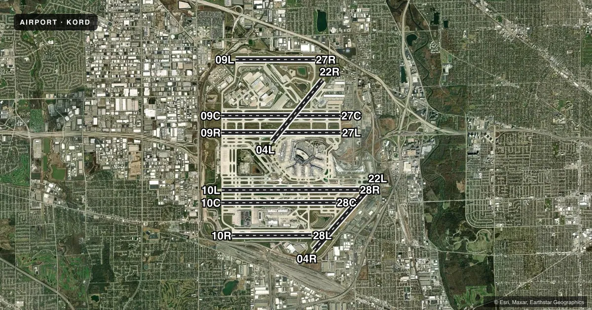
Runways & pattern
Full pagePattern entry · RWY 04L
LEFT TRAFFIC| Runway | Heading (°M) | Length | Surface | Traffic |
|---|---|---|---|---|
| 10L/28R | 87° / 267° | 13,000 ft | ASPH-CONC | Standard L |
| 09R/27L | 87° / 267° | 11,260 ft | ASPH-CONC | Standard L |
| 09C/27C | 87° / 267° | 11,245 ft | CONC | Standard L |
| 10C/28C | 87° / 267° | 10,800 ft | CONC | Standard L |
| 04R/22L | 39° / 219° | 8,075 ft | ASPH | Standard L |
| 04L/22RFavored | 36° / 216° | 7,500 ft | ASPH | Standard L |
| 10R/28L | 87° / 267° | 7,500 ft | CONC | Standard L |
| 09L/27R | 87° / 267° | 7,500 ft | CONC | Standard L |
Runway end performance
| End | TORA | TODA | ASDA | LDA | VGSI | Approach lights | Obstruction |
|---|---|---|---|---|---|---|---|
| 10L | 13,000' | 13,000' | 13,000' | 12,246' | PAPI 4-box left(3°) | ALSF2 | — |
| 28R | 13,000' | 13,000' | 13,000' | 13,000' | PAPI 4-box left(3°) | ALSF2 | 47', trees, 2336' from thr, 678' R of cntrln, slope 45 |
| 09R | 11,260' | 11,260' | 11,260' | 11,260' | PAPI 4-box left(3°) | ALSF2 | 47', tree, 2157' from thr, 252' R of cntrln, slope 41 |
| 27L | 11,260' | 11,260' | 11,260' | 11,260' | PAPI 4-box right(3°) | ALSF2 | 50', rr, 1938' from thr, 0' R of cntrln, slope 34 |
| 09C | 11,245' | 11,245' | 11,245' | 11,245' | PAPI 4-box left(3°) | ALSF2 | 126', ant, 5411' from thr, 721' R of cntrln, slope 41 |
| 27C | 11,245' | 11,245' | 11,245' | 11,245' | PAPI 4-box left(3°) | ALSF2 | — |
| 10C | 10,800' | 10,800' | 10,540' | 10,540' | PAPI 4-box left(3°) | ALSF2 | — |
| 28C | 10,800' | 10,800' | 10,800' | 10,800' | PAPI 4-box left(3°) | ALSF2 | — |
| 04R | 8,075' | 8,075' | 8,075' | 8,075' | PAPI 4-box right(3°) | MALSR | — |
| 22L | 8,075' | 8,075' | 8,075' | 8,075' | PAPI 4-box left(3°) | MALSR | 45', trees, 1997' from thr, 628' R of cntrln, slope 39 |
| 04L | 7,500' | 7,500' | 7,500' | — | — | — | — |
| 22R | — | — | — | 7,300' | PAPI 4-box left(3°) | MALSR | 43', trees, 2415' from thr, 640' R of cntrln, slope 50 |
| 10R | 7,500' | 7,500' | 7,500' | 7,500' | — | ALSF2 | 74', tree, 2555' from thr, 831' R of cntrln, slope 31 |
| 28L | 7,500' | 7,500' | 7,500' | 7,500' | — | ALSF2 | — |
| 09L | 7,500' | 7,500' | 7,500' | 7,500' | PAPI 4-box left(3°) | ALSF2 | 745', tower, 27413' from thr, 4442' R of cntrln, slope 36 |
| 27R | 7,500' | 7,500' | 7,500' | 7,500' | PAPI 4-box right(3°) | ALSF2 | 84', bldg, 3793' from thr, 118' R of cntrln, slope 42 |
Declared distances in feet. TORA = takeoff run available, TODA = takeoff distance, ASDA = accelerate-stop, LDA = landing distance.
Airport sketch
Runways drawn to scale from FAA survey coordinates, rendered over satellite imagery. Not for navigation.
Approaches & charts
ILS · 16
Services on the field
Fuel grades, oxygen, maintenance, ramp storage and lighting — as declared to the FAA by the airport operator.
Fuel & services
- Fuel
- 100LLA
- Oxygen (bottled)
- High pressure
- Oxygen (bulk)
- HIGH/LOW
- Airframe repair
- Major
- Power plant repair
- Major
Ramp & ground
- Transient storage
- Not published
- Landing fee
- Yes
- Customs
- Not available
- Beacon schedule
- SS-SR
- Beacon
- White / Green (civil land)(WG)
- Wind indicator
- Lighted
- Segmented circle
- No
Fuel & FBOs
Cheapest 100LL and Jet A on the field and nearby. Always confirm with the FBO before taxi.
Airport notes
Surface conditions, obstructions, local procedures, lighting outages and other notes published with each FAA cycle.
General notes
- NOISE ABATEMENT PROC IN EFFECT FM 2200 TO 0700; CTC AMGR - 773-686-2255.
- BIRDS ON & INVOF ARPT; PYROTECHNICS & BIRD CANNONS IN USE.
- ACFT WITH WINGSPAN GREATER THAN 214 FT RQR 48 HRS PPR - 773-686-2255.
- SEE LND & HOLD SHORT OPS SECTION.
- ALERT: DUPE ALPHA-NUMERIC TWY DESIGNATORS & TRML GATE DESIGNATIONS INVOLVING THE LTRS B, C, G, H, K, L & M.
- MAG DEVIATION PSBL IMT W OF TWY Y & RWY 22L APCH ON TWY N.
- PAEW NEAR VARIOUS TWYS.
- PERIODIC FIRE DEPT TRNG AT N SECTOR OF THE ARPT.
- PRIM RUN-UP LOCATION GROUND RUN UP ENCLOSURE; SECONDARY RUN UP LOCATIONS AVBL UPON REQ - CTC CITY OPS 773-686-2255.
- LINE UP AND WAIT AUTHORIZATION IN EFF BTWN SS AND SR AT THE FLWG INTS: RWY 28R AT TWY GG, TWY EE AND TWY N5; RWY 10L AT TWY DD AND TWY CC AND TWY SS; RWY 27C AT TWY TT; RWY 9C AT TWY FF; RWY 27L AT TWY TT; RWY 9R AT TWY SS AND FF. THESE RWYS WILL BE USED FOR DEPS ONLY WHEN EXERCISING THE PROVISIONS OF THIS AUTHORIZATION.
- ALL PART 91 & UNSKED PART 125, 133 & 135 CHARTER OPERATORS CTC SIGNATURE FLIGHT SUPPORT AT 773-686-7000 REGARDING NEW SECURITY REGULATIONS PRIOR TO DEP.
- EAST AND WEST GATES ARE MANNED 24 HRS A DAY.
- ATCT IS AUTH TO CONDUCT SIMUL DEPS FM RWY 04L/04R, RWY 22L/22R, RWY 09R WITH RWY 09L OR RWY 10L, RWY 09C WITH RWY 09L OR RWY 10L, RWY 10C WITH RWY 09R OR RWY 09C, RWY 27L WITH RWY 27R OR RWY 28R, RWY 27C WITH RWY 27R OR RWY 28R, RWY 28C WITH RWY 27L OR RWY 27C WITH CRS DIVERGENCE BEGINNING NO LATER THAN 4 MILES FM RWY END.
- BE ALERT: TWY S1 OBND OR EB ONLY, TWY S2 INBD OR WB ONLY, TWY P1, P2, P3, P5, AND P6 NB ONLY, TWY E1, E2, E3 & E4 SB ONLY. TWY E3 WB ONLY FM RWY 09C/27C.
- A380-800 OPR CONSTRAINTS EXIST ON RWYS, TWYS, & RAMPS - CTC ARPT OPS FOR INFO 773-686-2255.
- DVRSN ACRS WO A PRESENCE AT ORD SHOULD CTC ARPT OPNS 773-686-2255 PRIOR TO DIVERTING TO THE EXTENT PRACTICAL AND PRVD: CO, FLIGHT OPS CTC INFO, ACFT TYPE, PERSONS OB, INTL OR DOMESTIC, ANY GND HANDLER AGRMTS IN PLACE.
- BE ALERT: THE NORTHEAST/SOUTHWEST PORTION OF TWY YY IS NOT VSBL FM THE CENTER ATCT.
- B747-8 OPS NOT AUTHORIZED ON RWY 09R/27L, 09L/27R & 10R/28L.
- ACFT ARE NOT PMTD TO STOP ON EITHER TWY A OR B BRIDGES.
- RWY STATUS LGTS ARE IN OPN.
- TWY NN1 INBD/EB ONLY; TWY NN2 OUBD/WB ONLY.
- ORD TWY A17 CLSD TO ACFT WINGSPAN MORE THAN 96FT.
- ORD TXL SP CLSD TO ACFT WINGSPAN MORE THAN 167FT.
- ORD TXL SE CLSD TO ACFT WINGSPAN MORE THAN 118FT.
- ORD TWY A6 CLSD TO ACFT WINGSPAN MORE THAN 167FT.
Runway surface & condition
- 04L/22RPCR VALUE: 1180/R/C/W/T
- 04R/22LPCR VALUE: 1180/R/C/W/U
- 09C/27CPCR VALUE: 1180/R/C/W/T
- 09L/27RPCR VALUE: 800/R/C/W/U
- 09R/27LPCR VALUE: 1180/R/C/W/T
- 10C/28CPCR VALUE: 1180/R/C/W/T
- 10L/28RPCR VALUE: 1180/R/C/W/U
- 10R/28LPCR VALUE: 800/R/C/W/T
- 09R/27LTRIPLE DUAL TANDEM (3D) 768,000 LBS; DUAL TANDUM W/DUAL WHEEL (2D/D1) 632,755 LBS.
- 10XRWY 10X SUPPORTS THE SECOND STRAIGHT IN ILS SYSTEM I-IZJ ON RWY 10R.
- H1APCH/ DEP PATHS ARE EAST & WEST.
Approach & departure obstructions
- 04LCLSD TO ARR.
- 22RCLSD TO DEP.
- 27LPAPI UNUSBL BYD 8 DEGS RIGHT AND 9 DEGS LEFT OF CNTRLN.
Arresting gear
- 04R_EMASENGINEERED MATERIALS ARRESTING SYSTEM (EMAS), 170 FT WIDE BY 546 FT LENGTH, LCTD AT THE DER 04R.
- 22L_EMASENGINEERED MATERIALS ARRESTING SYSTEM (EMAS), 170 FT WIDE BY 303 FT LENGTH, LCTD AT THE DER 22L.
Other notes
- AND DU PAGE CO.
- MANAGERPLANNING INQUIRIES CTC MOLLY MONSERUD 773-686-3721
VFR map & nearby airports
VFR sectional. Tap any ICAO chip to open that airport.
Key facts · KORD
Answer card- ICAO
- KORD
- Name
- CHICAGO O'HARE INTL
- Location
- CHICAGO, ILLINOIS
- Elevation
- 680 ft MSL
- Traffic pattern altitude
- 1,680 ft MSL (1,000 AGL)
- Control tower
- Towered · 24
- Total runways
- 8
- Longest runway
- 10L/28R · 13,000 ft
- Published ILS approaches
- 16
- Published frequencies
- 42
- Magnetic variation
- 3°
- Current flight rules
- VFR
- Current wind
- 350° at 7 kt
- Favored runway now
- RWY 04L
Chicago O'Hare Intl sits in Chicago, Illinois. Field elevation is 680 ft MSL. This is a large, busy towered airport with 8 runways. The longest runway is 13,000 ft. The tower is open 24 hours. ILS approaches are available to many runway ends, which helps in the Midwest weather window when ceilings drop.
Pattern altitude is not published in the facts. For light piston planning, use 1,680 ft MSL as the standard 1,000 ft AGL reference unless ATC or the current Chart Supplement says otherwise. This is Class B airspace, so expect close ATC coordination and busy traffic flows. Runway status lights are in operation. The field also has simultaneous departure procedures on several runway pairs. Runway assignment can change fast.
Signature Aviation is on the field. It carries 100LL and Jet A. If you are diverting in without a presence at O'Hare, contact airport operations before arrival if practical. The published remarks also note that taxiway YY has a section not visible from the center tower. That is worth keeping in mind during taxi. Some runway-specific limits are published too, including a PAPI restriction on runway 27L and weight or operation notes on a few runways. Check the current FAA Chart Supplement before you go.