METAR & TAF 1C5
1C5 does not publish a METAR.
Showing the nearest reporting station: KLOT (LEWIS UNIVERSITY) · 5.5 NM away. Conditions at 1C5 may differ.
METAR · KLOT
Observed 03:55Z
KLOT 270355Z AUTO 19004KT 7SM SCT015 BKN028 OVC035 26/26 A2988 RMK AO2
- Wind
- 190° @ 4 kt
- Visibility
- 7 SM
- Temp / Dew
- 26°C / 26°C
- Altimeter
- 29.88 inHg
- Clouds
- OVC
- Density alt
- 2,206 ft
- Ceiling
- 2,800 ft AGL
- Rules
- MVFR
Airport info & contacts
Manager on record, flight service, ARTCC, attendance schedule and pattern altitude — published by the FAA and refreshed every 28 days.
Location
- From city
- 0 NM NW
- VFR sectional
- CHICAGO
- Pattern altitude
- 830 ft AGL · 1,505 ft MSL
- ARTCC
- ZAU · CHICAGO
- NOTAM facility
- IKK (NOTAM-D)
Airport manager
- Name
- JOSEPH DE PAULO
- Phone
- 630-378-0479
- Address
- 130 S CLOW INTL PARKWAY, BOLINGBROOK IL 60490
Flight service · Hours
- FSS IKK
- KANKAKEE1-800-WX-BRIEF
- Attendance
- 0700-1800
Frequencies
Tap any row to copy the frequency to your clipboard.
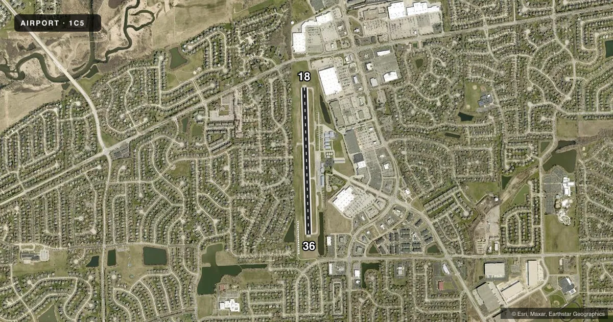
Runways & pattern
Full pagePattern entry · RWY 18
LEFT TRAFFICRunway end performance
| End | TORA | TODA | ASDA | LDA | VGSI | Approach lights | Obstruction |
|---|---|---|---|---|---|---|---|
| 18 | — | — | — | — | — | — | 34', tree, 697' from thr, 126' R of cntrln, slope 14 |
| 36 | — | — | — | — | — | — | 25', tree, 600' from thr, 16' R of cntrln, slope 16 |
Declared distances in feet. TORA = takeoff run available, TODA = takeoff distance, ASDA = accelerate-stop, LDA = landing distance.
Airport sketch
Runways drawn to scale from FAA survey coordinates, rendered over satellite imagery. Not for navigation.
Approaches & charts
Services on the field
Fuel grades, oxygen, maintenance, ramp storage and lighting — as declared to the FAA by the airport operator.
Fuel & services
- Fuel
- 100LLA
- Oxygen (bottled)
- Not available
- Oxygen (bulk)
- Not available
- Airframe repair
- Major
- Power plant repair
- Major
- Other services
- CHTR,INSTR,RNTL,SALES
Ramp & ground
- Transient storage
- Tie-down
- Hangar
- Landing fee
- No fee published
- Lighting schedule
- SEE RMK
- Beacon schedule
- SS-SR
- Beacon
- White / Green (civil land)(WG)
- Wind indicator
- Lighted
- Segmented circle
- No
Fuel & FBOs
Cheapest 100LL and Jet A on the field and nearby. Always confirm with the FBO before taxi.
Airport notes
Surface conditions, obstructions, local procedures, lighting outages and other notes published with each FAA cycle.
General notes
- TWY 20 FT WIDE; LARGE ACFT CONSIDER BACK-TAXI.
- NO TGL; FULL STOP LDG ONLY.
- FOR CD CTC CHICAGO APCH AT 847-289-0926.
- FLT SCHOOL OPS ONLY - 123.50.
- WILDLIFE ON AND INVOF ARPT.
- RESTAURANT ON ARPT.
Lighting notes
- MIRL RY 18/36 PRESET LOW INTST DUSK-DAWN TO INCR INTST - CTAF
Approach & departure obstructions
- 18USE RWY 18 IN CALM WND OR DRCT CROSSWINDS.
Other notes
- TFC PATTERNS SOUTH OF ARPT SHALL REMAIN WITHIN 3/4 MI.
- MANAGEREMAIL ADDRESS: JOEDEPAULO@GMAIL.COM
VFR map & nearby airports
VFR sectional. Tap any ICAO chip to open that airport.
Key facts · 1C5
Answer card- ICAO
- 1C5
- Name
- BOLINGBROOK'S CLOW INTL
- Location
- BOLINGBROOK, ILLINOIS
- Elevation
- 674.9 ft MSL
- Traffic pattern altitude
- 1,504.9 ft MSL (830 AGL)
- Control tower
- Non-towered (use CTAF)
- Total runways
- 1
- Longest runway
- 18/36 · 3,360 ft
- Published ILS approaches
- 0
- Published frequencies
- 3
- Magnetic variation
- 4°
- Current flight rules
- MVFR
- Current wind
- 190° at 4 kt
- Favored runway now
- RWY 18
BOLINGBROOK'S CLOW INTL (1C5) sits in Bolingbrook, Illinois. Field elevation is 674.9 ft MSL. The airport has one runway, 18/36, which is 3,360 ft long. There is no control tower. Pattern altitude is 830 ft AGL, which is 1,504.9 ft MSL.
No ILS approaches are published here. Plan for non-precision or visual work only. Verify current approach options in the FAA Chart Supplement before you go. JW Aviation is on the field. It carries AVGAS 100LL, JET A, PRIST and MOGAS.
The published remarks matter here. Use runway 18 in calm wind or direct crosswinds. Full stop landings only. No touch-and-goes. Traffic patterns south of the airport should stay within three quarters of a mile. Wildlife is reported on and near the airport, so keep your scan active on taxi and final. The runway lights are preset low from dusk to dawn. They then increase intensity on CTAF.
This is a small, busy local field with a narrow taxiway. Large aircraft should think ahead on taxi and may need to back-taxi. For clearance delivery, Chicago Approach is the published contact. If you need the latest noise or operational notes before departure, check the current FAA Chart Supplement or call the airport operator directly.