METAR & TAF KARR
Current METAR
Observed 13:13Z
KARR 271313Z COR 18006KT 1 1/4SM BR OVC002 26/25 A2984 RMK AO2 $
- Wind
- 180° @ 6 kt
- Visibility
- 0.25 SM
- Temp / Dew
- 26°C / 25°C
- Altimeter
- 29.84 inHg
- Clouds
- OVC
- Density alt
- 2,302 ft
- Ceiling
- 200 ft AGL
- Rules
- LIFR
Airport info & contacts
Manager on record, flight service, ARTCC, attendance schedule and pattern altitude — published by the FAA and refreshed every 28 days.
Location
- From city
- 38 NM W
- VFR sectional
- CHICAGO
- ARTCC
- ZAU · CHICAGO
- NOTAM facility
- ARR (NOTAM-D)
Airport manager
- Name
- STEVE ANDRAS
- Phone
- (630) 256-3120
- Address
- 43W 636 US30, SUGAR GROVE IL 60554
Flight service · Hours
- FSS IKK
- KANKAKEE1-800-WX-BRIEF
- Attendance
- 0600-2400
Frequencies
Tap any row to copy the frequency to your clipboard.
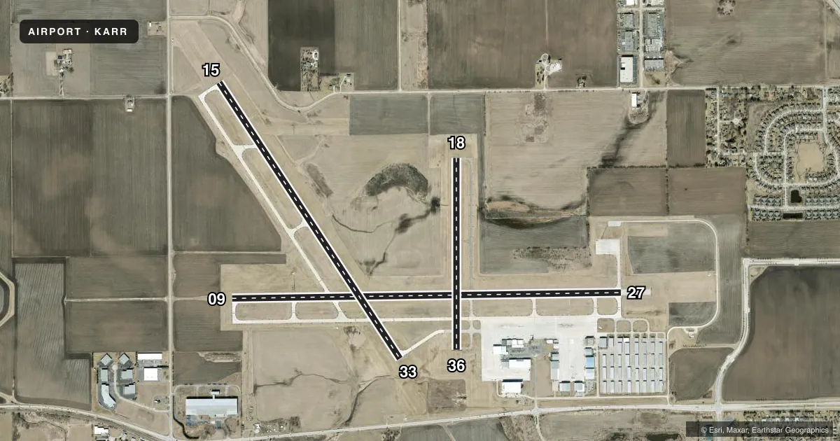
Runways & pattern
Full pagePattern entry · RWY 18
LEFT TRAFFIC| Runway | Heading (°M) | Length | Surface | Traffic |
|---|---|---|---|---|
| 09/27 | 88° / 268° | 6,501 ft | CONC | Standard L |
| 15/33 | 146° / 326° | 5,503 ft | CONC | Standard L |
| 18/36Favored | 179° / 359° | 3,198 ft | ASPH | Standard L |
Runway end performance
| End | TORA | TODA | ASDA | LDA | VGSI | Approach lights | Obstruction |
|---|---|---|---|---|---|---|---|
| 09 | — | — | 6,972' | — | PAPI 4-box left(3°) | MALSR | — |
| 27 | — | — | 6,460' | 6,460' | PAPI 4-box left(3°) | — | — |
| 15 | — | — | — | — | PAPI 4-box left(3°) | — | — |
| 33 | — | — | — | — | PAPI 4-box left(3°) | MALSR | — |
| 18 | — | — | — | — | PAPI 4-box left(3°) | — | — |
| 36 | — | — | — | — | VASI 4-box left(3°) | — | — |
Declared distances in feet. TORA = takeoff run available, TODA = takeoff distance, ASDA = accelerate-stop, LDA = landing distance.
Airport sketch
Runways drawn to scale from FAA survey coordinates, rendered over satellite imagery. Not for navigation.
Approaches & charts
ILS · 2
Services on the field
Fuel grades, oxygen, maintenance, ramp storage and lighting — as declared to the FAA by the airport operator.
Fuel & services
- Fuel
- 100A1
- Oxygen (bottled)
- HIGH/LOW
- Oxygen (bulk)
- HIGH/LOW
- Airframe repair
- Major
- Power plant repair
- Major
- Other services
- AFRT,AVNCS,CARGO,CHTR,INSTR,RNTL,SALES
Ramp & ground
- Transient storage
- Tie-down
- Hangar
- Landing fee
- No fee published
- Customs
- Not available
- Lighting schedule
- SEE RMK
- Beacon schedule
- SS-SR
- Beacon
- White / Green (civil land)(WG)
- Wind indicator
- Lighted
- Segmented circle
- No
Fuel & FBOs
Cheapest 100LL and Jet A on the field and nearby. Always confirm with the FBO before taxi.
Airport notes
Surface conditions, obstructions, local procedures, lighting outages and other notes published with each FAA cycle.
General notes
- SEASONAL CROPS IN PART 77 SURFACES RUNWAY 9/27 & 15/33
Lighting notes
- ACTVT MALSR RWY 09, 33; REIL RWY 18, 36,15, 27; TWY LGTS - CTAF. WHEN ATCT CLSD HIRL RWY 15/33, 09/27; MIRL RWY 18/36 PRESET LOW INTST, TO INCR INTST & ACTVT - CTAF.
Approach & departure obstructions
- 18RISING GROUND +6 FEET.
Other notes
- 800 FT FOR PISTON ACFT, & 1500 FTFOR FOR JET ACFT.
- FBO SVCS ON FREQ 122.95 AND 123.50.
- 18/36SEVERAL LARGE CRACKS & VEGETATIVE GROWTH.
VFR map & nearby airports
VFR sectional. Tap any ICAO chip to open that airport.
Key facts · KARR
Answer card- ICAO
- KARR
- Name
- AURORA MUNI
- Location
- CHICAGO/AURORA, ILLINOIS
- Elevation
- 712 ft MSL
- Traffic pattern altitude
- 1,712 ft MSL (1,000 AGL)
- Control tower
- Towered · 0700-2100
- Total runways
- 3
- Longest runway
- 09/27 · 6,501 ft
- Published ILS approaches
- 2
- Published frequencies
- 7
- Magnetic variation
- 1°
- Current flight rules
- LIFR
- Current wind
- 180° at 6 kt
- Favored runway now
- RWY 18
Aurora Muni sits in Chicago/Aurora, Illinois. Field elevation is 712 ft MSL. The airport has three runways. The longest is 6,501 ft on 09/27. The tower is open 0700-2100. Two ILS approaches are published for runway ends 09 and 33. Pattern altitude is not published in the facts, so use the standard 1,000 ft AGL for light piston traffic unless ATC or the current Chart Supplement says otherwise.
J.A. Air Center is on the field. It carries 100LL and Jet A Prist. The airport remarks also note that fixed base operator services are available on 122.95 and 123.50. That is useful if you need ramp help or fuel coordination before arrival. The published remarks flag cracks and vegetative growth on runway 18/36. There is also rising ground near the runway 18 end. Seasonal crops are present in the Part 77 surfaces for 09/27 and 15/33, so keep an eye out on the arrival and departure path.
Lighting is worth planning for. MALSR serves 09 and 33. REIL is available on 18, 36, 15 and 27. When the tower is closed, HIRL are available on 15/33 and 09/27. MIRL on 18/36 are preset to low intensity. Use CTAF to increase intensity and activate them. The airport has 800 ft limits for piston aircraft and 1,500 ft for jet aircraft. Check the current Chart Supplement for any noise or curfew restrictions before flying in.