METAR & TAF 0C2
0C2 does not publish a METAR.
Showing the nearest reporting station: KDKB (DE KALB TAYLOR MUNI) · 9.8 NM away. Conditions at 0C2 may differ.
METAR · KDKB
Observed 13:15Z
KDKB 261315Z AUTO 21005KT 1SM BR OVC003 22/22 A2996 RMK AO2 T02190219
- Wind
- 210° @ 5 kt
- Visibility
- 1 SM
- Temp / Dew
- 22°C / 22°C
- Altimeter
- 29.96 inHg
- Clouds
- OVC
- Density alt
- 1,733 ft
- Ceiling
- 300 ft AGL
- Rules
- LIFR
Airport info & contacts
Manager on record, flight service, ARTCC, attendance schedule and pattern altitude — published by the FAA and refreshed every 28 days.
Location
- From city
- 3 NM W
- VFR sectional
- CHICAGO
- ARTCC
- ZAU · CHICAGO
- NOTAM facility
- IKK (NOTAM-D)
Airport manager
- Name
- JIM BEYER
- Phone
- 316-213-7093
- Address
- PO BOX 812, HINCKLEY IL 60520
Flight service · Hours
- FSS IKK
- KANKAKEE1-800-WX-BRIEF
- Attendance
- IREG
Frequencies
Tap any row to copy the frequency to your clipboard.
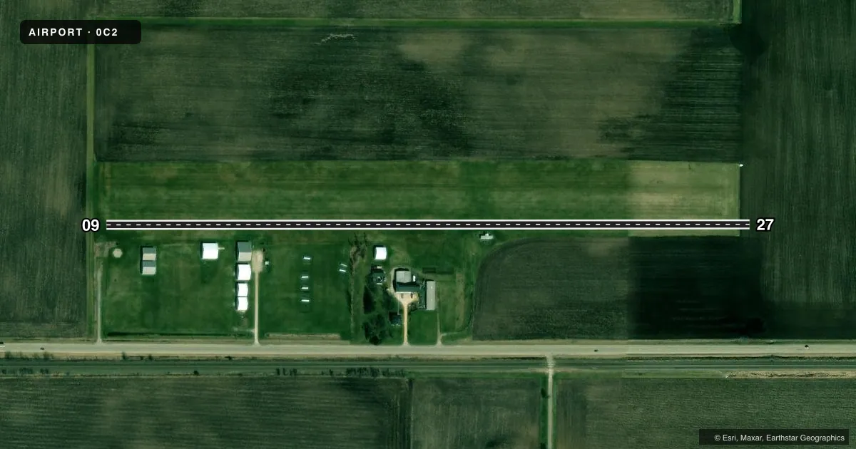
Runways & pattern
Full pagePattern entry · RWY 27
LEFT TRAFFICAirport sketch
Runways drawn to scale from FAA survey coordinates, rendered over satellite imagery. Not for navigation.
Approaches & charts
Services on the field
Fuel grades, oxygen, maintenance, ramp storage and lighting — as declared to the FAA by the airport operator.
Fuel & services
- Fuel
- Not available
- Oxygen (bottled)
- Not available
- Oxygen (bulk)
- Not available
- Other services
- GLD,INSTR,PAJA,TOW
Ramp & ground
- Transient storage
- Tie-down
- Landing fee
- No fee published
- Customs
- Not available
- Wind indicator
- Yes
- Segmented circle
- No
Fuel & FBOs
Cheapest 100LL and Jet A on the field and nearby. Always confirm with the FBO before taxi.
Airport notes
Surface conditions, obstructions, local procedures, lighting outages and other notes published with each FAA cycle.
General notes
- SOARING CONDUCTED AT ARPT.
- GLIDER OPNS SFC-17,500 FT.
- ARPT MAY BE UNUSBL UNDER VERY WET CONDS.
- RY 09/27 NOT PLOWED; USE AT OWN RISK.
- FOR CD CTC CHICAGO APCH AT 847-289-0926.
Approach & departure obstructions
- 09RYS 09 & 27 8 FT CROPS OFF RY ENDS DURING GROWING SEASON.
VFR map & nearby airports
VFR sectional. Tap any ICAO chip to open that airport.
Key facts · 0C2
Answer card- ICAO
- 0C2
- Name
- HINCKLEY
- Location
- HINCKLEY, ILLINOIS
- Elevation
- 760 ft MSL
- Traffic pattern altitude
- 1,760 ft MSL (1,000 AGL)
- Control tower
- Non-towered (use CTAF)
- Total runways
- 1
- Longest runway
- 09/27 · 2,640 ft
- Published ILS approaches
- 0
- Published frequencies
- 1
- Magnetic variation
- 0°
- Current flight rules
- LIFR
- Current wind
- 210° at 5 kt
- Favored runway now
- RWY 27
HINCKLEY (0C2) is in Hinckley, Illinois. The field elevation is 760 ft MSL. It has one runway, 09/27, which is 2,640 ft of turf. There is no control tower. CTAF is 122.9. No ILS approaches are published here.
Pattern altitude is not published, so use the standard 1,000 ft AGL unless the current Chart Supplement says otherwise. That puts the light piston pattern at about 1,760 ft MSL based on the field elevation. Glider operations and soaring are active here. The published remarks also say glider operations can extend from the surface up to 17,500 feet. Plan for mixed traffic and keep a sharp scan.
Runway 09/27 is not plowed. Use it at your own risk. The airport may also be unusable when the ground is very wet. There are 8-foot crops off both runway ends during the growing season. For clearance delivery, Chicago Approach is listed at 847-289-0926. No on-field FBOs are listed, so contact the airport operator directly before arrival or call the field on CTAF for current service availability.