METAR & TAF KDKB
Current METAR
Observed 10:55Z
KDKB 261055Z AUTO 00000KT 1/2SM FG OVC003 21/21 A2994 RMK AO2 T02120212
- Wind
- 000° @ 0 kt
- Visibility
- 0.5 SM
- Temp / Dew
- 21°C / 21°C
- Altimeter
- 29.94 inHg
- Clouds
- OVC
- Density alt
- 1,827 ft
- Ceiling
- 300 ft AGL
- Rules
- LIFR
Airport info & contacts
Manager on record, flight service, ARTCC, attendance schedule and pattern altitude — published by the FAA and refreshed every 28 days.
Location
- From city
- 2 NM E
- VFR sectional
- CHICAGO
- ARTCC
- ZAU · CHICAGO
- NOTAM facility
- DKB (NOTAM-D)
Airport manager
- Name
- BENJAMIN TROMPETER
- Phone
- 815-748-8102
- Address
- 3232 PLEASANT STREET, DEKALB IL 60115
Flight service · Hours
- FSS IKK
- KANKAKEE1-800-WX-BRIEF
- Attendance
- NOV-FEB · 0800-1600
- MAR-OCT · 0800-1700
Frequencies
Tap any row to copy the frequency to your clipboard.
Runways & pattern
Full pagePattern entry · RWY 02
LEFT TRAFFIC| Runway | Heading (°M) | Length | Surface | Traffic |
|---|---|---|---|---|
| 02/20 | 17° / 197° | 7,026 ft | ASPH | Standard L |
| 09/27 | 88° / 268° | 4,201 ft | ASPH | Standard L |
Runway end performance
| End | TORA | TODA | ASDA | LDA | VGSI | Approach lights | Obstruction |
|---|---|---|---|---|---|---|---|
| 02 | — | — | — | — | PAPI 4-box left(3°) | MALSR | 21', rr, 1237' from thr, 650' R of cntrln, slope 50 |
| 20 | — | — | — | — | PAPI 4-box left(3°) | — | — |
| 09 | — | — | — | — | PAPI 4-box left(3°) | — | — |
| 27 | — | — | — | — | PAPI 4-box left(3°) | — | 40', tree, 1464' from thr, 170' R of cntrln, slope 31 |
Declared distances in feet. TORA = takeoff run available, TODA = takeoff distance, ASDA = accelerate-stop, LDA = landing distance.
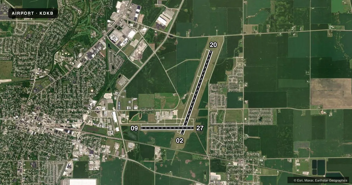
Airport sketch
Runways drawn to scale from FAA survey coordinates, rendered over satellite imagery. Not for navigation.
Approaches & charts
ILS · 1
Services on the field
Fuel grades, oxygen, maintenance, ramp storage and lighting — as declared to the FAA by the airport operator.
Fuel & services
- Fuel
- 100LLA1+
- Oxygen (bottled)
- Low pressure
- Airframe repair
- Major
- Power plant repair
- Major
- Other services
- AFRT,CARGO,INSTR,RNTL
Ramp & ground
- Transient storage
- Tie-down
- Hangar
- Landing fee
- No fee published
- Customs
- Not available
- Lighting schedule
- SEE RMK
- Beacon schedule
- SS-SR
- Beacon
- White / Green (civil land)(WG)
- Wind indicator
- Lighted
- Segmented circle
- No
Fuel & FBOs
Cheapest 100LL and Jet A on the field and nearby. Always confirm with the FBO before taxi.
Airport notes
Surface conditions, obstructions, local procedures, lighting outages and other notes published with each FAA cycle.
General notes
- FOR CD CTC CHICAGO APCH AT 847-289-0926.
- PRFERED CALM WIND RWY 02
Lighting notes
- MIRL RWY 02/20 PRESET LOW INTST, TO INCR INTST & ACTVT MIRL RWY 09/27, PAPI RWYS 09 & 27, REIL RWYS 09, 27, & 20, AND MALSR RWY 02 - CTAF. PAPI RWYS 02 & 20 OPERATE 24 HRS.
Fuel notes
- 100LL100LL 24 HR SELF SERVE WITH CREDIT CARD
VFR map & nearby airports
VFR sectional. Tap any ICAO chip to open that airport.
Key facts · KDKB
Answer card- ICAO
- KDKB
- Name
- DE KALB TAYLOR MUNI
- Location
- DE KALB, ILLINOIS
- Elevation
- 912.6 ft MSL
- Traffic pattern altitude
- 1,912.6 ft MSL (1,000 AGL)
- Control tower
- Non-towered (use CTAF)
- Total runways
- 2
- Longest runway
- 02/20 · 7,026 ft
- Published ILS approaches
- 1
- Published frequencies
- 4
- Magnetic variation
- 2°
- Current flight rules
- LIFR
- Current wind
- 000° at 0 kt
- Favored runway now
- –
De Kalb Taylor Muni is in De Kalb, Illinois. Field elevation is 912.6 ft MSL. The airport has 2 asphalt runways. The longest is 7,026 ft on 02/20. There is no control tower, so plan on CTAF self-announce work on 122.7. The published pattern altitude is not listed. Use the standard 1,000 ft AGL pattern for light piston unless the current Chart Supplement says otherwise.
Runway 02 has the published ILS. That matters if you are planning an instrument arrival in marginal weather. The field also has a preferred calm wind runway of 02. Medium intensity runway lights on 02/20 are preset to low intensity. If you need more lighting on 09/27, use the CTAF to activate it. Use the CTAF to activate the PAPI and runway end lights on those ends. The PAPI on 02 and 20 operates 24 hours.
DeKalb Taylor Municipal Airport is the on-field FBO. It carries 100LL and Jet A Prist. 100LL is available 24 hours self-serve with credit card. For clearance delivery, contact Chicago Approach at 847-289-0926. First-time arrivals should pay attention to the non-towered traffic flow, the ILS on 02 and the lighting setup if arriving after dark.