METAR & TAF C77
C77 does not publish a METAR.
Showing the nearest reporting station: KRFD (CHICAGO/ROCKFORD INTL) · 13.9 NM away. Conditions at C77 may differ.
METAR · KRFD
Observed 13:54Z
KRFD 271354Z 16008KT 2 1/2SM BR OVC004 27/26 A2981 RMK AO2 SLP089 T02670261
- Wind
- 160° @ 8 kt
- Visibility
- 0.5 SM
- Temp / Dew
- 27°C / 26°C
- Altimeter
- 29.81 inHg
- Clouds
- OVC
- Density alt
- 2,640 ft
- Ceiling
- 400 ft AGL
- Rules
- LIFR
Airport info & contacts
Manager on record, flight service, ARTCC, attendance schedule and pattern altitude — published by the FAA and refreshed every 28 days.
Location
- From city
- 3 NM S
- VFR sectional
- CHICAGO
- ARTCC
- ZAU · CHICAGO
- NOTAM facility
- IKK (NOTAM-D)
Airport manager
- Name
- BKAKE . THOMAS
- Phone
- 815-544-3471
- Address
- 11619 RT 76, POPLAR GROVE IL 61065
Flight service · Hours
- FSS IKK
- KANKAKEE1-800-WX-BRIEF
- Attendance
- SR-SS
Frequencies
Tap any row to copy the frequency to your clipboard.
Runways & pattern
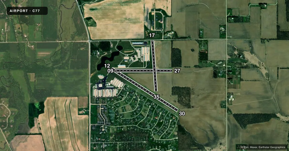
Full pagePattern entry · RWY 17
LEFT TRAFFIC| Runway | Heading (°M) | Length | Surface | Traffic |
|---|---|---|---|---|
| 12/30 | 120° / 300° | 3,773 ft | ASPH | Standard L |
| 09/27 | 87° / 267° | 2,709 ft | TURF | Standard L |
| 17/35Favored | 173° / 353° | 2,467 ft | TURF | Standard L |
Runway end performance
| End | TORA | TODA | ASDA | LDA | VGSI | Approach lights | Obstruction |
|---|---|---|---|---|---|---|---|
| 27 | — | — | — | — | — | — | 62', tree, 655' from thr, 155' R of cntrln, slope 10 |
| 17 | — | — | — | — | — | — | 17', road, 0' from thr, 0' R of cntrln, slope 0 |
Declared distances in feet. TORA = takeoff run available, TODA = takeoff distance, ASDA = accelerate-stop, LDA = landing distance.
Airport sketch
Runways drawn to scale from FAA survey coordinates, rendered over satellite imagery. Not for navigation.
Approaches & charts
Services on the field
Fuel grades, oxygen, maintenance, ramp storage and lighting — as declared to the FAA by the airport operator.
Fuel & services
- Fuel
- 100LL
- Oxygen (bottled)
- Not available
- Oxygen (bulk)
- Not available
- Airframe repair
- Major
- Power plant repair
- Major
- Other services
- AFRT,AVNCS,CARGO,CHTR,INSTR,RNTL,SALES
Ramp & ground
- Transient storage
- Tie-down
- Hangar
- Landing fee
- No fee published
- Lighting schedule
- SS-SR
- Beacon schedule
- SS-SR
- Beacon
- White / Green (civil land)(WG)
- Wind indicator
- Lighted
- Segmented circle
- No
Fuel & FBOs
Cheapest 100LL and Jet A on the field and nearby. Always confirm with the FBO before taxi.
Airport notes
Surface conditions, obstructions, local procedures, lighting outages and other notes published with each FAA cycle.
General notes
- CAUTION: IMPAIRED SIGHT CLNCS BTN RWY ENDS DUE TO ROLLING TRRN.
- FOR CD CTC CHICAGO ARTCC AT 630-906-8921.
- RWY 12/30 MARKINGS POOR.
Runway surface & condition
- 09/27CLSD WHEN SNOW COVERED EXCP TO SKI ACFT.
- 17/35CLSD WHEN SNOW COVERED EXCP TO SKI ACFT.
- 12/30NSTD LIRL DUE TO SPACING, INTST & NON-FRANGIBLE MOUNTINGS.
Approach & departure obstructions
- 12MKD WITH WHITE BARS UNDER NUMBERS; NO ARROWS.
- 17MKD WITH THREE CONES ON EACH SIDE OF RWY.
- 30CALM WIND RWY.
- 12APCH SLOPE IS 32:1 AT DSPLCD THR.
- 17APCH SLOPE IS 20:1 AT DSPLCD THR.
Other notes
- THIS AIRPORT HAS BEEN SURVEYED BY THE NATIONAL GEODETIC SURVEY.
- MANAGEREMAIL ADDRESS: STEVE@POPLARGROVEAIRMOTIVE.COM (ALL LOWER CASE)
- OWNERALT BLAKE THOMAS
VFR map & nearby airports
VFR sectional. Tap any ICAO chip to open that airport.
Key facts · C77
Answer card- ICAO
- C77
- Name
- POPLAR GROVE
- Location
- POPLAR GROVE, ILLINOIS
- Elevation
- 857.4 ft MSL
- Traffic pattern altitude
- 1,857.4 ft MSL (1,000 AGL)
- Control tower
- Non-towered (use CTAF)
- Total runways
- 3
- Longest runway
- 12/30 · 3,773 ft
- Published ILS approaches
- 0
- Published frequencies
- 4
- Magnetic variation
- 3°
- Current flight rules
- LIFR
- Current wind
- 160° at 8 kt
- Favored runway now
- RWY 17
Poplar Grove Airport sits in Poplar Grove, Illinois. Field elevation is 857.4 ft MSL. The airport has three runways. The longest is runway 12/30 at 3,773 ft asphalt. Runways 09/27 and 17/35 are turf. There is no control tower. CTAF and UNICOM are both 122.8. Rockford Approach is on 121.0 and 327.0.
No ILS approaches are published here. Pattern altitude is not published, so use the standard 1,000 ft AGL for light piston operations unless the current Chart Supplement says otherwise. Poplar Grove Airmotive is on the field. It carries 100LL. Call (815) 544-3471 for current service details.
A few published remarks matter for planning. Runway 12/30 has poor markings. Runways 12/30 also have nonstandard low intensity runway lights. Runway 17 has three cones on each side. Runways 09/27 and 17/35 are closed when snow covered except for ski aircraft. The field also has rolling terrain between runway ends, so sight lines can be deceptive on the ground and in the pattern. Runway 30 is listed as the calm wind runway. If you need clearance delivery, contact Chicago ARTCC at 630-906-8921. Check the current Chart Supplement before you go for any updates on local procedures or restrictions.