METAR & TAF 44C
44C does not publish a METAR.
Showing the nearest reporting station: KJVL (SOUTHERN WISCONSIN RGNL) · 8.0 NM away. Conditions at 44C may differ.
METAR · KJVL
Observed 12:45Z
KJVL 271245Z 20006KT 2SM BR OVC006 26/ A2981
- Wind
- 200° @ 6 kt
- Visibility
- 2 SM
- Temp / Dew
- —
- Altimeter
- 29.81 inHg
- Clouds
- OVC
- Density alt
- —
- Ceiling
- 600 ft AGL
- Rules
- IFR
Airport info & contacts
Manager on record, flight service, ARTCC, attendance schedule and pattern altitude — published by the FAA and refreshed every 28 days.
Location
- From city
- 3 NM E
- VFR sectional
- CHICAGO
- Pattern altitude
- 700 ft AGL · 1,517 ft MSL
- ARTCC
- ZAU · CHICAGO
- NOTAM facility
- GRB (NOTAM-D)
Airport manager
- Name
- STEVE STAUBER
- Phone
- 773-914-9938
- Address
- 4046 STATE HWY 67, BELOIT WI 53511
Flight service · Hours
- FSS GRB
- GREEN BAY1-800-WX-BRIEF
- Attendance
- MAY-AUG · MON-FRI · 1000-1400
Frequencies
Tap any row to copy the frequency to your clipboard.
Runways & pattern
Full pagePattern entry · RWY 25
LEFT TRAFFICRunway end performance
| End | TORA | TODA | ASDA | LDA | VGSI | Approach lights | Obstruction |
|---|---|---|---|---|---|---|---|
| 25 | — | — | — | — | — | — | 15', road, 200' from thr, 65' R of cntrln, slope 0 |
Declared distances in feet. TORA = takeoff run available, TODA = takeoff distance, ASDA = accelerate-stop, LDA = landing distance.
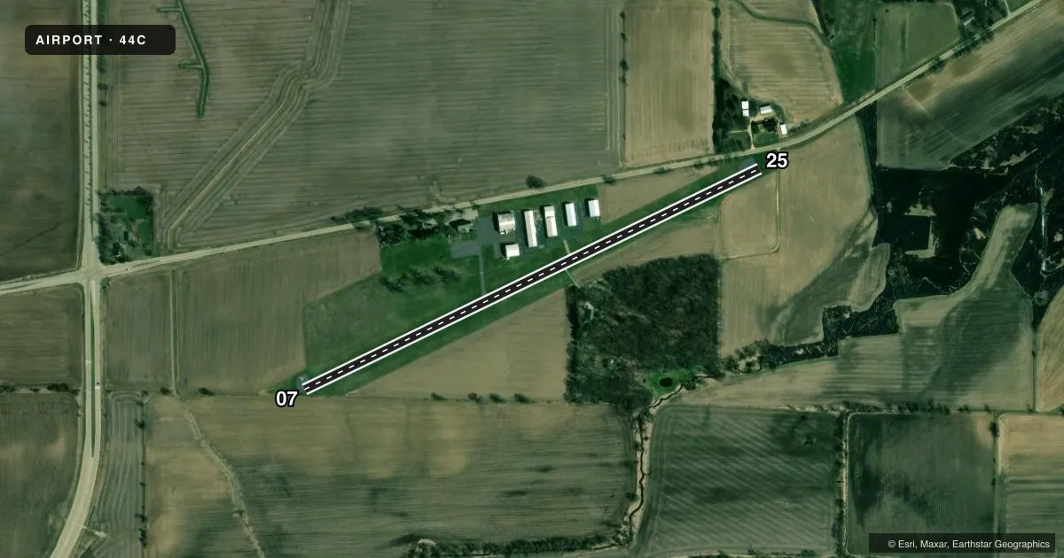
Airport sketch
Runways drawn to scale from FAA survey coordinates, rendered over satellite imagery. Not for navigation.
Approaches & charts
Services on the field
Fuel grades, oxygen, maintenance, ramp storage and lighting — as declared to the FAA by the airport operator.
Fuel & services
- Fuel
- 100LL
- Oxygen (bottled)
- Not available
- Oxygen (bulk)
- Not available
- Airframe repair
- Not available
- Power plant repair
- Not available
- Other services
- PAJA
Ramp & ground
- Transient storage
- Tie-down
- Hangar
- Landing fee
- No fee published
- Customs
- Not available
- Lighting schedule
- SEE RMK
- Beacon schedule
- SS-SR
- Beacon
- White / Green (civil land)(WG)
- Wind indicator
- Lighted
- Segmented circle
- No
Fuel & FBOs
Cheapest 100LL and Jet A on the field and nearby. Always confirm with the FBO before taxi.
Airport notes
Surface conditions, obstructions, local procedures, lighting outages and other notes published with each FAA cycle.
General notes
- FOR CD CTC CHICAGO ARTCC AT 630-906-8921.
Lighting notes
- ACTVT LIRL RY 07/25 - CTAF.
Runway surface & condition
- 07/25NSTD LIRL 100 FT WIDE; 50 FT LEFT & RIGHT OF RY CNTRLN.
Approach & departure obstructions
- 2515 FT ROAD 0 - 200 FT FM RWY END; 65 - 110 FT R.
- 25APCH RTIO 10:1 TO DSPLCD THLD; 54 FT SILO 560 FT FM DSPLCD THLD 190 FT R.
- 07NSTD THR MARKINGS; LCTD 92 FT FM END OF PAVEMENT.
- 25APCH RATIO 20:1 TO DTHR.
Other notes
- MANAGEREMAIL ADDRESS: SHSTAUBER@AOL.COM (ALL LOWER CASE)
VFR map & nearby airports
VFR sectional. Tap any ICAO chip to open that airport.
Key facts · 44C
Answer card- ICAO
- 44C
- Name
- BELOIT
- Location
- BELOIT, WISCONSIN
- Elevation
- 817 ft MSL
- Traffic pattern altitude
- 1,517 ft MSL (700 AGL)
- Control tower
- Non-towered (use CTAF)
- Total runways
- 1
- Longest runway
- 07/25 · 3,300 ft
- Published ILS approaches
- 0
- Published frequencies
- 4
- Magnetic variation
- 3°
- Current flight rules
- IFR
- Current wind
- 200° at 6 kt
- Favored runway now
- RWY 25
Beloit Airport sits in Beloit, Wisconsin. Field elevation is 817 ft MSL. The airport has one runway. Runway 07/25 is 3,300 ft asphalt, which is the longest runway on the field. There is no control tower. The pattern altitude is 700 ft AGL, which is 1,517 ft MSL.
No ILS approaches are published here. If you need current approach or airspace details, check the current FAA Chart Supplement before you go. CTAF and UNICOM are both 122.7. Rockford approach and departure are listed on 121.0 and 327.0. Low intensity runway lights on 07/25 are activated through the CTAF. The runway lighting is nonstandard in width, so pay attention to the centerline and threshold cues on final.
Published remarks also note a displaced threshold on runway 25 with nearby obstructions. There is a 54 ft silo near the approach path and a road close to the runway end. Runway 07 has nonstandard threshold markings set back from the pavement end. There are no on-field FBOs listed, so call the airport operator directly or the field on CTAF for current services before arrival. For clearance delivery, Chicago ARTCC is listed in the remarks. This is a small non-towered field, so plan for self-announce traffic and verify current conditions before a night or low-visibility arrival.