METAR & TAF KDPA
Current METAR
Observed 16:06Z
KDPA 271606Z 17013KT 6SM -TSRA BR OVC011 28/26 A2973 RMK AO2 LTG DSNT NW-NE TSB00 P0000 T02780261
- Wind
- 170° @ 13 kt
- Visibility
- 6 SM
- Temp / Dew
- 28°C / 26°C
- Altimeter
- 29.73 inHg
- Clouds
- OVC
- Density alt
- 2,736 ft
- Ceiling
- 1,100 ft AGL
- Rules
- MVFR
Airport info & contacts
Manager on record, flight service, ARTCC, attendance schedule and pattern altitude — published by the FAA and refreshed every 28 days.
Location
- From city
- 29 NM W
- VFR sectional
- CHICAGO
- ARTCC
- ZAU · CHICAGO
- NOTAM facility
- DPA (NOTAM-D)
Airport manager
- Name
- MARK DOLES
- Phone
- 630-584-2211
- Address
- 2700 INT'L DRIVE, STE 200, WEST CHICAGO IL 60185-0787
Flight service · Hours
- FSS IKK
- KANKAKEE1-800-WX-BRIEF
- Attendance
- ALL
Frequencies
Tap any row to copy the frequency to your clipboard.
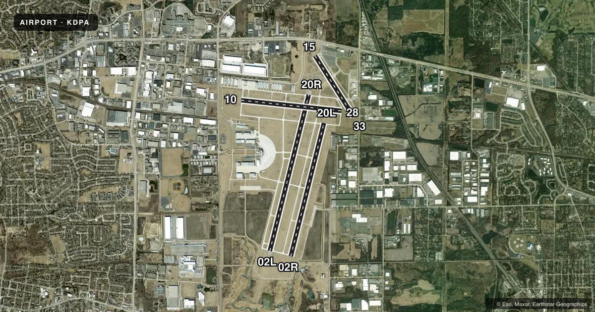
Runways & pattern
Full pagePattern entry · RWY 15
LEFT TRAFFIC| Runway | Heading (°M) | Length | Surface | Traffic |
|---|---|---|---|---|
| 02L/20R | 13° / 193° | 7,571 ft | CONC | Standard L |
| 02R/20L | 13° / 193° | 6,451 ft | CONC | 02R R |
| 10/28 | 95° / 275° | 4,750 ft | ASPH | Standard L |
| 15/33Favored | 147° / 327° | 3,399 ft | ASPH | Standard L |
Runway end performance
| End | TORA | TODA | ASDA | LDA | VGSI | Approach lights | Obstruction |
|---|---|---|---|---|---|---|---|
| 02L | — | — | — | — | — | MALSR | — |
| 20R | — | — | — | — | PAPI 4-box left(3°) | — | — |
| 10 | — | — | — | — | VASI 4-box left(3°) | RLLS | 34', bldg, 1743' from thr, 0' R of cntrln, slope 44 |
| 28 | — | — | — | — | PAPI 4-box left(3°) | — | — |
| 15 | — | — | — | — | PAPI 4-box right(3.9°) | — | 91', tree, 1750' from thr, 205' R of cntrln, slope 17 |
| 33 | — | — | — | — | — | — | 55', tree, 893' from thr, 183' R of cntrln, slope 12 |
Declared distances in feet. TORA = takeoff run available, TODA = takeoff distance, ASDA = accelerate-stop, LDA = landing distance.
Airport sketch
Runways drawn to scale from FAA survey coordinates, rendered over satellite imagery. Not for navigation.
Approaches & charts
ILS · 2
Services on the field
Fuel grades, oxygen, maintenance, ramp storage and lighting — as declared to the FAA by the airport operator.
Fuel & services
- Fuel
- 100LLA
- Oxygen (bottled)
- HIGH/LOW
- Oxygen (bulk)
- HIGH/LOW
- Airframe repair
- Major
- Power plant repair
- Major
- Other services
- AFRT,AVNCS,CARGO,CHTR,INSTR,RNTL,SALES
Ramp & ground
- Transient storage
- Tie-down
- Hangar
- Landing fee
- No fee published
- Customs
- Not available
- Lighting schedule
- SEE RMK
- Beacon
- White / Green (civil land)(WG)
- Wind indicator
- Lighted
- Segmented circle
- No
Fuel & FBOs
Cheapest 100LL and Jet A on the field and nearby. Always confirm with the FBO before taxi.
Airport notes
Surface conditions, obstructions, local procedures, lighting outages and other notes published with each FAA cycle.
General notes
- DEER, COYOTE, BIRDS & MIGRATORY WATERFOWL ON & INVOF ARPT.
- ACFT ON SHORT FINAL TO RY 15 ARE NOT VSB FROM ATCT DUE TO TREES.
- ARFF INDEX B PPR
- US CUST SVC AVBL PPR.
- INT DEP RWY 20R AT TWY G HAS 6141'.
Lighting notes
- ATC-CTL
Fuel notes
- 100LL100LL SELF SER AVBL 24HR WITH CREDIT CARD.
Approach & departure obstructions
- 33+13 FT ROAD 199 FT FM RY END 125 FT R.
- 10UNUSBL BYD 5 DEG RIGHT AND LEFT OF CNTRLN.
- 33APCH RATIO IS 20:1 TO DSPLCD THLD.
Other notes
- MANAGEREMAIL ADDRESS: DBIRD@DUPAGEAIRPORT.GOV (ALL LOWER CASE)
VFR map & nearby airports
VFR sectional. Tap any ICAO chip to open that airport.
Key facts · KDPA
Answer card- ICAO
- KDPA
- Name
- DUPAGE
- Location
- CHICAGO/WEST CHICAGO, ILLINOIS
- Elevation
- 758.5 ft MSL
- Traffic pattern altitude
- 1,758.5 ft MSL (1,000 AGL)
- Control tower
- Towered · 24
- Total runways
- 4
- Longest runway
- 02L/20R · 7,571 ft
- Published ILS approaches
- 2
- Published frequencies
- 9
- Magnetic variation
- 1°
- Current flight rules
- MVFR
- Current wind
- 170° at 13 kt
- Favored runway now
- RWY 15
DuPage Airport sits in Chicago and West Chicago, Illinois. Field elevation is 758.5 ft MSL. The airport has 4 runways. The longest is 7,571 ft on 02L/20R. DuPage has a control tower that operates 24 hours. Two ILS approaches are published. They serve runway ends 02L and 10. Pattern altitude is not published, so use the standard 1,000 ft AGL for light piston traffic unless ATC or the current Chart Supplement says otherwise.
DuPage Flight Center is on the field. It carries 100LL and Jet A. 100LL self-serve is available 24 hours with credit card. That makes fuel planning simple for late arrivals. The airport also has published notes that matter on a first visit. The visual glide slope indicator is unusable more than 5 degrees left or right of centerline. There are deer, coyotes, birds and migratory waterfowl in the area. Aircraft on short final to runway 15 are not visible from the tower because of trees. Runway 20R at taxiway G has an intersection departure length of 6,141 ft. Check the current Chart Supplement for any customs or ARFF prior permission details before you go. This is a busy controlled field near Chicago. Expect close attention to taxi, runway selection and tower instructions.