METAR & TAF C09
Current METAR
Observed 04:27Z
KC09 180427Z AUTO 28013G19KT 10SM CLR 21/18 A2945 RMK AO2
- Wind
- 280° @ 13G19 kt
- Visibility
- 10 SM
- Temp / Dew
- 21°C / 18°C
- Altimeter
- 29.45 inHg
- Clouds
- CLR
- Density alt
- 2,028 ft
- Ceiling
- Unlimited
- Rules
- VFR
Airport info & contacts
Manager on record, flight service, ARTCC, attendance schedule and pattern altitude — published by the FAA and refreshed every 28 days.
Location
- From city
- 4 NM N
- VFR sectional
- CHICAGO
- ARTCC
- ZAU · CHICAGO
- NOTAM facility
- C09 (NOTAM-D)
Airport manager
- Name
- RYAN CRYDER
- Phone
- 815-942-1600
- Address
- 9980 NO. HIGHWAY 47, MORRIS IL 60450
Flight service · Hours
- FSS IKK
- KANKAKEE1-800-WX-BRIEF
- Attendance
- 0700-1700
Frequencies
Tap any row to copy the frequency to your clipboard.
Runways & pattern
Full pagePattern entry · RWY 36
LEFT TRAFFICRunway end performance
| End | TORA | TODA | ASDA | LDA | VGSI | Approach lights | Obstruction |
|---|---|---|---|---|---|---|---|
| 18 | — | — | — | — | PAPI 4-box left(3°) | — | — |
| 36 | — | — | — | — | PAPI 4-box right(3°) | — | — |
Declared distances in feet. TORA = takeoff run available, TODA = takeoff distance, ASDA = accelerate-stop, LDA = landing distance.
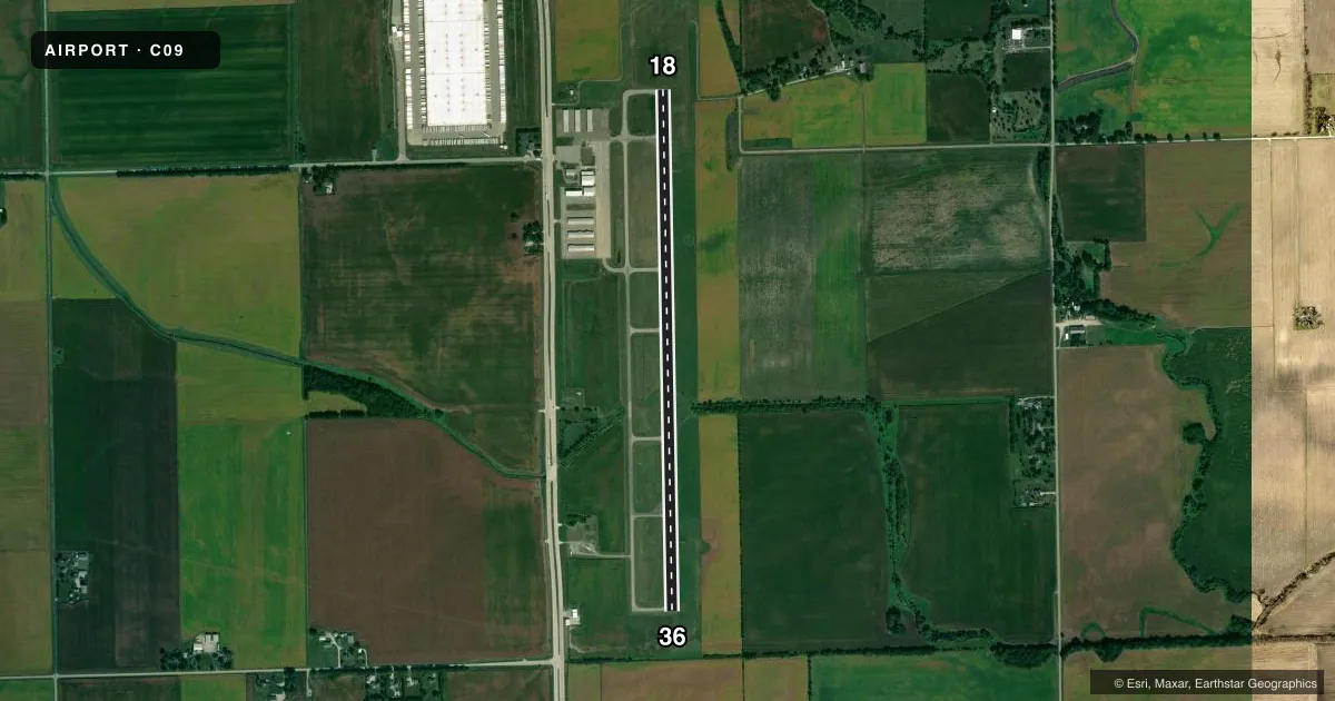
Airport sketch
Runways drawn to scale from FAA survey coordinates, rendered over satellite imagery. Not for navigation.
Approaches & charts
Services on the field
Fuel grades, oxygen, maintenance, ramp storage and lighting — as declared to the FAA by the airport operator.
Fuel & services
- Fuel
- 100LLA+
- Airframe repair
- Not available
- Power plant repair
- Not available
- Other services
- INSTR
Ramp & ground
- Transient storage
- Tie-down
- Hangar
- Landing fee
- No fee published
- Customs
- Not available
- Lighting schedule
- SEE RMK
- Beacon schedule
- SS-SR
- Beacon
- White / Green (civil land)(WG)
- Wind indicator
- Lighted
- Segmented circle
- Yes
Fuel & FBOs
Cheapest 100LL and Jet A on the field and nearby. Always confirm with the FBO before taxi.
Airport notes
Surface conditions, obstructions, local procedures, lighting outages and other notes published with each FAA cycle.
General notes
- FOR CD CTC CHICAGO APCH AT 847-289-0926.
- SELF SERVE 100LL FUEL PUMP
Lighting notes
- RWY 18/36 MIRL AND RWY 18 & 36 REIL ON PHOTO CELL. MIRL RWY 18/36 PRESET ON LOW INTST; TO INCR INTST & ACTVT REIL RWY 18 & 36 - CTAF.
Other notes
- EXISTED PRIOR TO 1959.
VFR map & nearby airports
VFR sectional. Tap any ICAO chip to open that airport.
Key facts · C09
Answer card- ICAO
- C09
- Name
- MORRIS MUNI/JAMES R WASHBURN FLD
- Location
- MORRIS, ILLINOIS
- Elevation
- 584.7 ft MSL
- Traffic pattern altitude
- 1,584.7 ft MSL (1,000 AGL)
- Control tower
- Non-towered (use CTAF)
- Total runways
- 1
- Longest runway
- 18/36 · 5,501 ft
- Published ILS approaches
- 0
- Published frequencies
- 4
- Magnetic variation
- 3°
- Current flight rules
- VFR
- Current wind
- 280° at 13 kt
- Favored runway now
- RWY 36
Morris Muni/James R Washburn Fld sits in Morris, Illinois. Field elevation is 584.7 ft MSL. The airport has one runway. Runway 18/36 is 5,501 ft asphalt. There is no control tower. CTAF and UNICOM are both 122.8. Chicago Approach handles clearance delivery. No ILS approaches are published here.
Pattern altitude is not published. Use the standard 1,000 ft AGL pattern for light piston traffic unless the current Chart Supplement says otherwise. The on-field FBO is Morris Municipal Airport. It carries 100LL, Jet A and Jet A Prist. Call (815) 942-1600 for current service details before you go.
Published remarks note medium intensity runway lights on 18/36. The lights are preset low. Use CTAF to increase intensity. Use CTAF to activate the runway end identifier lights. That matters after dark or in low visibility. The field also has a long history. It existed before 1959.
For a first-time arrival, the main things to plan for are the non-towered pattern, Chicago Approach coordination for clearances and the lighting setup if you are arriving at night. Check the current FAA Chart Supplement for any changes before flight.