METAR & TAF KDTG
KDTG does not publish a METAR.
Showing the nearest reporting station: KPNT (PONTIAC MUNI) · 15.1 NM away. Conditions at KDTG may differ.
METAR · KPNT
Observed 15:55Z
KPNT 271555Z 10SM CLR 31/26 A2983 RMK AO2 T03060261 PWINO
- Wind
- Calm
- Visibility
- 10 SM
- Temp / Dew
- 31°C / 26°C
- Altimeter
- 29.83 inHg
- Clouds
- CLR
- Density alt
- 2,815 ft
- Ceiling
- Unlimited
- Rules
- VFR
Airport info & contacts
Manager on record, flight service, ARTCC, attendance schedule and pattern altitude — published by the FAA and refreshed every 28 days.
Location
- From city
- 3 NM N
- VFR sectional
- CHICAGO
- Pattern altitude
- 800 ft AGL · 1,432 ft MSL
- ARTCC
- ZAU · CHICAGO
- NOTAM facility
- IKK (NOTAM-D)
Airport manager
- Name
- DAN RIBORDY
- Phone
- (815) 374-4319
- Address
- PO BOX 214, DWIGHT IL 60420
Flight service · Hours
- FSS IKK
- KANKAKEE1-800-WX-BRIEF
- Attendance
- Unattended
Frequencies
Tap any row to copy the frequency to your clipboard.
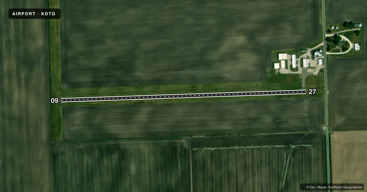
Runways & pattern
Full pagePattern entry · RWY 09
LEFT TRAFFICRunway end performance
| End | TORA | TODA | ASDA | LDA | VGSI | Approach lights | Obstruction |
|---|---|---|---|---|---|---|---|
| 09 | — | — | — | — | — | — | 8', crops, 200' from thr, 0' R of cntrln, slope 0 |
| 27 | — | — | — | — | — | — | 15', road, 200' from thr, 180' R of cntrln, slope 0 |
Declared distances in feet. TORA = takeoff run available, TODA = takeoff distance, ASDA = accelerate-stop, LDA = landing distance.
Airport sketch
Runways drawn to scale from FAA survey coordinates, rendered over satellite imagery. Not for navigation.
Approaches & charts
Services on the field
Fuel grades, oxygen, maintenance, ramp storage and lighting — as declared to the FAA by the airport operator.
Fuel & services
- Fuel
- 100LL
Ramp & ground
- Transient storage
- Tie-down
- Hangar
- Landing fee
- No fee published
- Customs
- Not available
- Lighting schedule
- SEE RMK
- Beacon schedule
- SEE RMK
- Beacon
- White / Green (civil land)(WG)
- Wind indicator
- Yes
- Segmented circle
- No
Fuel & FBOs
Cheapest 100LL and Jet A on the field and nearby. Always confirm with the FBO before taxi.
Airport notes
Surface conditions, obstructions, local procedures, lighting outages and other notes published with each FAA cycle.
General notes
- FOR CD CTC CHICAGO ARTCC AT 630-906-8921.
Lighting notes
- FOR ROTG BCN CALL 815-258-8218.
- FOR LIRL RY 09/27 AFTER 2200 CALL 815-258-8218.
Runway surface & condition
- 09/27RY 09/27 NSTD LIRL; NOT FAA APPROVED L-800 SERIES. SPACING & INTST OF LGTS VARY.
- 09/2721' ASPH STRIP CENTERED ON 100' TURF STRIP.
Approach & departure obstructions
- 09RWY 09, 8 FT CROP 100 FT FM END OF RWY, OB CNTRLN, 12 TO 1.
- 27RWY 27 15 FT RD 185 FT FM RY END 0B CNTRLN.
- 0909/27 NSTD MKGS DUE TO NARROW WIDTH.
- 09CONTROLLING OBSTN EXCEEDS A 45 DEG SLP.
- 27CONTROLLING OBSTN EXCEEDS A 45 DEG SLP.
Other notes
- MANAGEREMAIL ADDRESS: DTGAERO@GMAIL.COM (ALL LOWER CASE)
VFR map & nearby airports
VFR sectional. Tap any ICAO chip to open that airport.
Key facts · KDTG
Answer card- ICAO
- KDTG
- Name
- DWIGHT
- Location
- DWIGHT, ILLINOIS
- Elevation
- 632 ft MSL
- Traffic pattern altitude
- 1,432 ft MSL (800 AGL)
- Control tower
- Non-towered (use CTAF)
- Total runways
- 1
- Longest runway
- 09/27 · 2,364 ft
- Published ILS approaches
- 0
- Published frequencies
- 2
- Magnetic variation
- 2°
- Current flight rules
- VFR
- Current wind
- Calm / unavailable
- Favored runway now
- –
Dwight Airport (KDTG) sits in Dwight, Illinois. Field elevation is 632 ft MSL. The airport has one runway, 09/27, which is 2,364 ft long. There is no control tower. CTAF and UNICOM are both 122.8. Pattern altitude is 800 ft AGL, which is 1,432 ft MSL.
No ILS approaches are published here. That matters for IFR planning. Check the current FAA Chart Supplement for the latest approach and lighting details before you go. The runway is a narrow asphalt strip centered on turf. Runway 09 and 27 also have nonstandard markings because of the width. Published remarks note controlling obstructions on both ends. Runway 09 has an 8-foot crop about 100 feet from the end. Runway 27 has a 15-foot road about 185 feet from the runway end. The runway lights are nonstandard low intensity lights. Spacing and intensity can vary.
Dwight Aero Service is on the field. It carries 100LL. For low intensity runway lights after 2200. For the rotating beacon, call the number in the Chart Supplement or the airport operator before arrival. This is a small non-towered field with a short runway, so plan your performance carefully. The published magnetic variation is 2°.