METAR & TAF KJOT
Current METAR
Observed 15:55Z
KJOT 271555Z AUTO 21009KT 7SM OVC013 30/28 A2978 RMK AO2 T02950275
- Wind
- 210° @ 9 kt
- Visibility
- 7 SM
- Temp / Dew
- 30°C / 28°C
- Altimeter
- 29.78 inHg
- Clouds
- OVC
- Density alt
- 2,696 ft
- Ceiling
- 1,300 ft AGL
- Rules
- MVFR
Airport info & contacts
Manager on record, flight service, ARTCC, attendance schedule and pattern altitude — published by the FAA and refreshed every 28 days.
Location
- From city
- 4 NM W
- VFR sectional
- CHICAGO
- ARTCC
- ZAU · CHICAGO
- NOTAM facility
- JOT (NOTAM-D)
Airport manager
- Name
- JENNIFER MCFARLAND
- Phone
- 815-741-7267
- Address
- 4000 W JEFFERSON, JOLIET IL 60431
Flight service · Hours
- FSS IKK
- KANKAKEE1-800-WX-BRIEF
- Attendance
- MON-FRI · 0700-1800
- SAT · 0700-1300
- SUN · UNATND
Frequencies
Tap any row to copy the frequency to your clipboard.
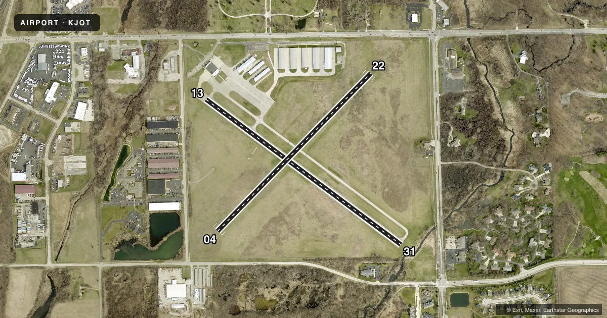
Runways & pattern
Full pagePattern entry · RWY 22
LEFT TRAFFIC| Runway | Heading (°M) | Length | Surface | Traffic |
|---|---|---|---|---|
| 13/31 | 124° / 304° | 2,821 ft | ASPH | Standard L |
| 04/22Favored | 41° / 221° | 2,552 ft | TURF | Standard L |
Runway end performance
| End | TORA | TODA | ASDA | LDA | VGSI | Approach lights | Obstruction |
|---|---|---|---|---|---|---|---|
| 13 | — | — | — | — | PAPI 4-box right(3.5°) | — | 21', tree, 373' from thr, 0' R of cntrln, slope 8 |
| 31 | — | — | — | — | — | — | 51', tree, 839' from thr, 30' R of cntrln, slope 12 |
| 22 | — | — | — | — | — | — | 89', tree, 1283' from thr, 40' R of cntrln, slope 14 |
Declared distances in feet. TORA = takeoff run available, TODA = takeoff distance, ASDA = accelerate-stop, LDA = landing distance.
Airport sketch
Runways drawn to scale from FAA survey coordinates, rendered over satellite imagery. Not for navigation.
Approaches & charts
Services on the field
Fuel grades, oxygen, maintenance, ramp storage and lighting — as declared to the FAA by the airport operator.
Fuel & services
- Fuel
- 100LLAMOGAS
- Oxygen (bottled)
- Not available
- Oxygen (bulk)
- Not available
- Airframe repair
- Major
- Power plant repair
- Major
- Other services
- CHTR,INSTR,RNTL,SALES
Ramp & ground
- Transient storage
- Tie-down
- Hangar
- Landing fee
- No fee published
- Customs
- Not available
- Lighting schedule
- SEE RMK
- Beacon schedule
- SS-SR
- Beacon
- White / Green (civil land)(WG)
- Wind indicator
- Lighted
- Segmented circle
- No
Fuel & FBOs
Cheapest 100LL and Jet A on the field and nearby. Always confirm with the FBO before taxi.
Airport notes
Surface conditions, obstructions, local procedures, lighting outages and other notes published with each FAA cycle.
General notes
- FOR CD CTC CHICAGO APCH AT 847-289-0926.
Lighting notes
- MIRL RY 13/31 PRESET ON LOW INTST - TO ACTVT INCR INTST PAPI RY 13; MIRL RY 13/31 - CTAF.
Approach & departure obstructions
- 04RWY 04 /22 MKD WITH TIRES PAINTED WHITE; THLD MKD WITH WHITE GRAVEL. RWY 13/31 MARKINGS FADED.
- 13APCH RATIO 16:1 TO DTHR. +51 RT TREE, DIST 827 FT, 45 RT L, APPROACH SLOPE 16:1 TO DISLACE THHD.
- 31APCH RATIO 18:1 TO DTHR.
Other notes
- EXISTED PRIOR TO 1959.
VFR map & nearby airports
VFR sectional. Tap any ICAO chip to open that airport.
Key facts · KJOT
Answer card- ICAO
- KJOT
- Name
- JOLIET RGNL
- Location
- JOLIET, ILLINOIS
- Elevation
- 582.3 ft MSL
- Traffic pattern altitude
- 1,582.3 ft MSL (1,000 AGL)
- Control tower
- Non-towered (use CTAF)
- Total runways
- 2
- Longest runway
- 13/31 · 2,821 ft
- Published ILS approaches
- 0
- Published frequencies
- 4
- Magnetic variation
- 3°
- Current flight rules
- MVFR
- Current wind
- 210° at 9 kt
- Favored runway now
- RWY 22
Joliet Regional Airport sits in Joliet, Illinois. Field elevation is 582.3 ft MSL. The airport has two runways. The longest is 13/31 at 2,821 ft. It is a non-towered field, so expect self-announce traffic on CTAF 122.7. Watch the pattern closely.
No ILS approaches are published here. Pattern altitude is not published, so use the standard 1,000 ft AGL pattern unless current local guidance says otherwise. The on-field FBO is Joliet Regional Airport. It carries AVGAS 100LL, Jet A and mogas. Call (815) 741-7267 before arrival if you need current ramp or fuel availability.
There are a few items a first-time pilot should know. Runway 13/31 has medium intensity lights that are preset low. Use the PAPI on runway 13 to increase intensity. Runway 04/22 is marked with tires painted white. Its threshold is marked with white gravel. Runway 13/31 markings are faded. There is also an obstruction note for the approach to runway 13. A 51-foot tree sits near the displaced threshold area. The airport existed before 1959. If you need clearance delivery, Chicago Approach publishes a phone number in the Chart Supplement. Check the current FAA Chart Supplement before you go.