METAR & TAF 10C
10C does not publish a METAR.
Showing the nearest reporting station: KBUU (BURLINGTON MUNI) · 17.6 NM away. Conditions at 10C may differ.
METAR · KBUU
Observed 15:55Z
KBUU 271555Z AUTO 13005KT 5SM SCT008 BKN023 OVC050 25/23 A2969 RMK AO2 P0002 T02450230 PWINO
- Wind
- 130° @ 5 kt
- Visibility
- 5 SM
- Temp / Dew
- 25°C / 23°C
- Altimeter
- 29.69 inHg
- Clouds
- OVC
- Density alt
- 2,570 ft
- Ceiling
- 2,300 ft AGL
- Rules
- MVFR
Airport info & contacts
Manager on record, flight service, ARTCC, attendance schedule and pattern altitude — published by the FAA and refreshed every 28 days.
Location
- From city
- 1 NM N
- VFR sectional
- CHICAGO
- Pattern altitude
- 800 ft AGL · 1,675 ft MSL
- ARTCC
- ZAU · CHICAGO
- NOTAM facility
- IKK (NOTAM-D)
Airport manager
- Name
- JUSTIN CLELAND
- Phone
- 815-648-2433
- Address
- 5112 GREENWOOD ROAD, WONDER LAKE IL 60097
Flight service · Hours
- FSS IKK
- KANKAKEE1-800-WX-BRIEF
- Attendance
- 0800-1700
Frequencies
Tap any row to copy the frequency to your clipboard.
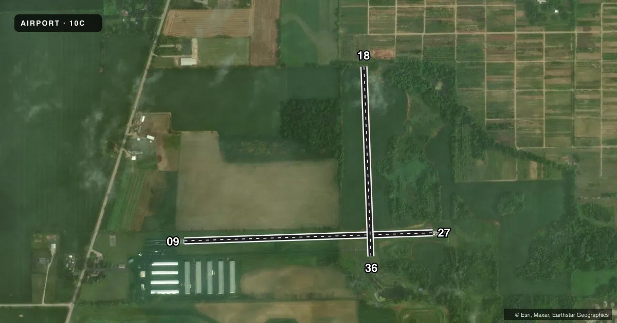
Runways & pattern
Full pagePattern entry · RWY 09
LEFT TRAFFICAirport sketch
Runways drawn to scale from FAA survey coordinates, rendered over satellite imagery. Not for navigation.
Approaches & charts
Services on the field
Fuel grades, oxygen, maintenance, ramp storage and lighting — as declared to the FAA by the airport operator.
Fuel & services
- Fuel
- 100LL
- Oxygen (bottled)
- Not available
- Oxygen (bulk)
- Not available
- Airframe repair
- Major
- Power plant repair
- Major
- Other services
- INSTR,RNTL
Ramp & ground
- Transient storage
- Tie-down
- Hangar
- Landing fee
- No fee published
- Customs
- Not available
- Beacon schedule
- SS-SR
- Beacon
- White / Green (civil land)(WG)
- Wind indicator
- Lighted
Fuel & FBOs
Cheapest 100LL and Jet A on the field and nearby. Always confirm with the FBO before taxi.
Airport notes
Surface conditions, obstructions, local procedures, lighting outages and other notes published with each FAA cycle.
General notes
- DEER ON & INVOF ARPT.
- FOR CD CTC CHICAGO APCH AT 847-289-0926.
- 100LL SELF SERVE FUEL AVAILABLE 24 HR WITH CREDIT CARD
Runway surface & condition
- 09/27RY 09/27 NSTD LIRL WITH NSTD SPACING; 2669 FT LGTD AT NIGHT.
Approach & departure obstructions
- 09RWY 09 HAS +10 FT TERRAIN 136 FT FROM RUNWAY END AND 5 FT LEFT OF RWY CENTERLINE. CLEAR 20:1 TO MARKED DISPLACED THRESHOLD
- 09CLEAR 20:1 TO RWY 09 THRESHOLD
Other notes
- THIS AIRPORT HAS BEEN SURVEYED BY THE NATIONAL GEODETIC SURVEY.
- EXISTED PRIOR TO 1959.
- MANAGEREMAIL ADDRESS: JUSTIN@FLYWITHJB.COM (ALL LOWER CASE)
- OWNERDIANE SONDAY - PHONE 815-648-2433
VFR map & nearby airports
VFR sectional. Tap any ICAO chip to open that airport.
Key facts · 10C
Answer card- ICAO
- 10C
- Name
- GALT FLD
- Location
- GREENWOOD/WONDER LAKE, ILLINOIS
- Elevation
- 875 ft MSL
- Traffic pattern altitude
- 1,675 ft MSL (800 AGL)
- Control tower
- Non-towered (use CTAF)
- Total runways
- 2
- Longest runway
- 09/27 · 2,802 ft
- Published ILS approaches
- 0
- Published frequencies
- 4
- Magnetic variation
- 2°
- Current flight rules
- MVFR
- Current wind
- 130° at 5 kt
- Favored runway now
- RWY 09
Galt Fld sits in Greenwood/Wonder Lake, Illinois. Field elevation is 875 ft MSL. The airport has two runways. The longest is runway 09/27 at 2,802 ft. Runway 18/36 is 2,141 ft turf. The field is not towered. Pattern altitude is 800 ft AGL. That is 1,675 ft MSL.
No ILS approaches are published here. For clearance delivery, Chicago Approach is listed in the remarks. The published remarks also note deer on and near the airport. That matters here. Plan for a careful scan on taxi, takeoff and landing. Runway 09 has a terrain note near the departure end. The 09/27 lighting is nonstandard low intensity lighting with nonstandard spacing. Only 2,669 ft is lighted at night.
JB Aviation is on the field. It carries 100LL. Published remarks also say 100LL self-serve fuel is available 24 hours with credit card. If you are new to the airport, use the current Chart Supplement for any operational updates before departure. The airport has been surveyed by the National Geodetic Survey. It also existed before 1959.