METAR & TAF KBUU
Current METAR
Observed 16:55Z
KBUU 271655Z AUTO 16005KT 10SM BKN033 OVC042 22/21 A2974 RMK AO2 T02170210 PWINO
- Wind
- 160° @ 5 kt
- Visibility
- 10 SM
- Temp / Dew
- 22°C / 21°C
- Altimeter
- 29.74 inHg
- Clouds
- OVC
- Density alt
- 2,031 ft
- Ceiling
- 3,300 ft AGL
- Rules
- VFR
Airport info & contacts
Manager on record, flight service, ARTCC, attendance schedule and pattern altitude — published by the FAA and refreshed every 28 days.
Location
- From city
- 1 NM NW
- VFR sectional
- CHICAGO
- ARTCC
- ZAU · CHICAGO
- NOTAM facility
- BUU (NOTAM-D)
Airport manager
- Name
- PAUL AYDT
- Phone
- 262-342-5003
- Address
- 707 AIRPORT DRIVE, BURLINGTON WI 53105
Flight service · Hours
- FSS GRB
- GREEN BAY1-800-WX-BRIEF
- Attendance
- 0800-DUSK
Frequencies
Tap any row to copy the frequency to your clipboard.
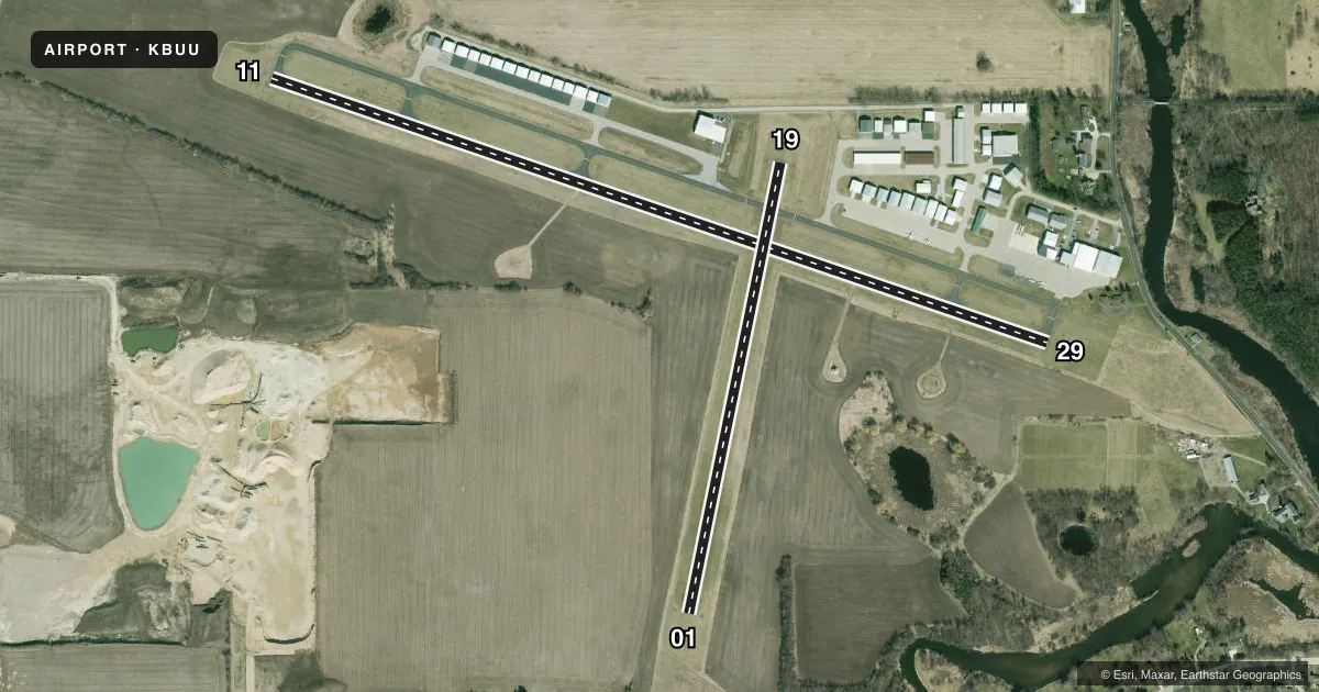
Runways & pattern
Full pagePattern entry · RWY 19
RIGHT TRAFFIC| Runway | Heading (°M) | Length | Surface | Traffic |
|---|---|---|---|---|
| 11/29 | 106° / 286° | 4,300 ft | ASPH | 29 R |
| 01/19Favored | 9° / 189° | 2,410 ft | TURF | 19 R |
Runway end performance
| End | TORA | TODA | ASDA | LDA | VGSI | Approach lights | Obstruction |
|---|---|---|---|---|---|---|---|
| 11 | — | — | — | — | PAPI 2-box left(3.5°) | — | — |
| 29 | — | — | — | — | PAPI 2-box left(3.25°) | — | — |
Declared distances in feet. TORA = takeoff run available, TODA = takeoff distance, ASDA = accelerate-stop, LDA = landing distance.
Airport sketch
Runways drawn to scale from FAA survey coordinates, rendered over satellite imagery. Not for navigation.
Approaches & charts
Services on the field
Fuel grades, oxygen, maintenance, ramp storage and lighting — as declared to the FAA by the airport operator.
Fuel & services
- Fuel
- 100LLA+
- Oxygen (bottled)
- Low pressure
- Oxygen (bulk)
- Not available
- Airframe repair
- Major
- Power plant repair
- Major
- Other services
- INSTR,RNTL,SALES
Ramp & ground
- Transient storage
- Tie-down
- Hangar
- Landing fee
- No fee published
- Customs
- Not available
- Lighting schedule
- SEE RMK
- Beacon schedule
- SS-SR
- Beacon
- White / Green (civil land)(WG)
- Wind indicator
- Lighted
- Segmented circle
- Yes
Fuel & FBOs
Cheapest 100LL and Jet A on the field and nearby. Always confirm with the FBO before taxi.
Airport notes
Surface conditions, obstructions, local procedures, lighting outages and other notes published with each FAA cycle.
General notes
- ASPH TWY 30 FT WIDE, EXCEPT 'W' 700 FT 35 FT WIDE.
- DEPARTING TFC CLIMB TO 1000 FT AGL BEFORE TURNING SOUTH.
- WATERFOWL ON & INVOF ARPT.
- TFC DEPARTING RY 11 AVOID OVERFLIGHT OF CITY.
- GCO AVBL ON FREQ 121.725 THRU FLT SVCS.
- FOR CD CTC CHICAGO ARTCC AT 630-906-8921.
Lighting notes
- MIRL RWY 11/29 PRESET TO LOW SS-SR; TO INCR INTST & ACTVT REIL RWY 11 & 29; MIRL RWY 11/29 - CTAF. PAPI RWY 11 & 29 OPR CONSLY.
Fuel notes
- 100LL24 HR SELF SVC FUEL AVBL WITH CREDIT CARD.
Approach & departure obstructions
- 01MKD WITH YELLOW/BLACK WOODEN PANELS.
- 19MKD WITH YELLOW/BLACK WOODEN PANELS.
Other notes
- MANAGEREMAIL ADDRESS: PAYDT@BURLINGTON-WI.GOV.
VFR map & nearby airports
VFR sectional. Tap any ICAO chip to open that airport.
Key facts · KBUU
Answer card- ICAO
- KBUU
- Name
- BURLINGTON MUNI
- Location
- BURLINGTON, WISCONSIN
- Elevation
- 780.1 ft MSL
- Traffic pattern altitude
- 1,780.1 ft MSL (1,000 AGL)
- Control tower
- Non-towered (use CTAF)
- Total runways
- 2
- Longest runway
- 11/29 · 4,300 ft
- Published ILS approaches
- 0
- Published frequencies
- 4
- Magnetic variation
- 3°
- Current flight rules
- VFR
- Current wind
- 160° at 5 kt
- Favored runway now
- RWY 19
Burlington Muni sits in Burlington, Wisconsin. The field elevation is 780.1 ft MSL. It has two runways. The longest is 11/29 at 4,300 ft of asphalt. Runway 01/19 is turf at 2,410 ft. There is no control tower. No ILS approaches are published, so plan with the current chart and weather brief for your arrival.
Pattern altitude is not published. Use the standard 1,000 ft AGL pattern unless current local guidance says otherwise. The field has published remarks that matter on a first visit. Traffic departing runway 11 should avoid overflying the city. Departing traffic should climb to 1,000 ft AGL before turning south. Waterfowl are on and near the airport, so expect bird activity on the ground and in the circuit. Runway 01 and runway 19 are marked with yellow and black wooden panels.
Burlington Municipal Airport is the on-field FBO. It carries 100LL and Jet A Prist. Twenty-four hour self-serve 100LL is available with credit card. CTAF and UNICOM are both 123.05. For clearance delivery, contact Chicago ARTCC at 630-906-8921. Ground communications outlet is available on 121.725 through flight services. The airport is in the Milwaukee approach area, so check the current FAA Chart Supplement and brief the airspace before you go.