METAR & TAF C89
C89 does not publish a METAR.
Showing the nearest reporting station: KENW (KENOSHA RGNL) · 6.6 NM away. Conditions at C89 may differ.
METAR · KENW
Observed 14:50Z
KENW 271450Z 17011KT 5SM BR BKN006 BKN009 BKN022 28/26 A2980 RMK AO2
- Wind
- 170° @ 11 kt
- Visibility
- 5 SM
- Temp / Dew
- 28°C / 26°C
- Altimeter
- 29.80 inHg
- Clouds
- BKN
- Density alt
- 2,687 ft
- Ceiling
- 600 ft AGL
- Rules
- IFR
Airport info & contacts
Manager on record, flight service, ARTCC, attendance schedule and pattern altitude — published by the FAA and refreshed every 28 days.
Location
- From city
- 3 NM W
- VFR sectional
- CHICAGO
- ARTCC
- ZAU · CHICAGO
- NOTAM facility
- GRB (NOTAM-D)
Airport manager
- Name
- ROBERT MC KAY
- Phone
- 847-445-7817
- Address
- 2624 SOUTH SYLVANIA AVE, STURTEVANT WI 53177
Flight service · Hours
- FSS GRB
- GREEN BAY1-800-WX-BRIEF
- Attendance
- IRREG
Frequencies
Tap any row to copy the frequency to your clipboard.
Runways & pattern
Full pagePattern entry · RWY 26L
LEFT TRAFFIC| Runway | Heading (°M) | Length | Surface | Traffic |
|---|---|---|---|---|
| 08L/26R | 79° / 259° | 2,343 ft | TURF | Standard L |
| 08R/26LFavored | 79° / 259° | 2,272 ft | ASPH | Standard L |
Runway end performance
| End | TORA | TODA | ASDA | LDA | VGSI | Approach lights | Obstruction |
|---|---|---|---|---|---|---|---|
| 08L | — | — | — | — | — | — | 18', road, 90' from thr, 134' R of cntrln, slope 5 |
| 26R | — | — | — | — | — | — | 15', road, 95' from thr, 0' R of cntrln, slope 6 |
| 08R | — | — | — | — | — | — | 18', road, 320' from thr, 140' R of cntrln, slope 6 |
| 26L | — | — | — | — | PAPI 2-box left | — | 18', road, 200' from thr, 0' R of cntrln, slope 0 |
Declared distances in feet. TORA = takeoff run available, TODA = takeoff distance, ASDA = accelerate-stop, LDA = landing distance.
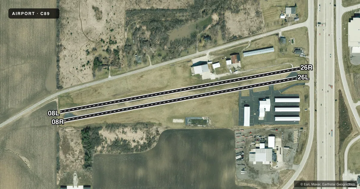
Airport sketch
Runways drawn to scale from FAA survey coordinates, rendered over satellite imagery. Not for navigation.
Approaches & charts
Services on the field
Fuel grades, oxygen, maintenance, ramp storage and lighting — as declared to the FAA by the airport operator.
Fuel & services
- Fuel
- 100LL
- Oxygen (bottled)
- Not available
- Oxygen (bulk)
- Not available
- Airframe repair
- Not available
- Power plant repair
- Not available
- Other services
- INSTR,PAJA,RNTL
Ramp & ground
- Transient storage
- Tie-down
- Hangar
- Landing fee
- No fee published
- Customs
- Not available
- Lighting schedule
- SEE RMK
- Beacon schedule
- SEE RMK
- Beacon
- White / Green (civil land)(WG)
- Wind indicator
- Lighted
- Segmented circle
- No
Fuel & FBOs
Cheapest 100LL and Jet A on the field and nearby. Always confirm with the FBO before taxi.
Airport notes
Surface conditions, obstructions, local procedures, lighting outages and other notes published with each FAA cycle.
General notes
- ULTRALIGHTS ON & IN VCNTY OF ARPT.
- PARA ATVT ON & IN VCNTY OF ARPT.
- RY 08R/26L CLSD TO HEL AUTOROTATION MNVRS.
- FOR CD CTC CHICAGO ARTCC AT 630-906-8921.
Lighting notes
- ACTVT ARPT BCN SS-SR - CTAF.
- ACTVT PAPI RY 26L; MIRL RY 08R/26L - CTAF.
Fuel notes
- 100LL24 HR FUEL AVBL WITH CREDIT CARD.
Runway surface & condition
- 08R/26LRY 08R/26L NSTD MIRL.
Approach & departure obstructions
- 08R10 FT BRUSH 100 FT FM THR, 65 FT R.
- 26LROAD 0-80 FT FM RWY END, 50 FT L; ROAD 80 FT FM RWY END, BOTH SIDES OF CNTRLN.
- 26LAPCH RATIO 20:1 TO DTHR.
Other notes
- PRIOR TO 1959.
- 08L/26RRUF AREA IN FNT OF SKY DIVING HNGR APPXLY 800 FT W OF RWY 26R THLD.
VFR map & nearby airports
VFR sectional. Tap any ICAO chip to open that airport.
Key facts · C89
Answer card- ICAO
- C89
- Name
- SYLVANIA
- Location
- STURTEVANT, WISCONSIN
- Elevation
- 789 ft MSL
- Traffic pattern altitude
- 1,789 ft MSL (1,000 AGL)
- Control tower
- Non-towered (use CTAF)
- Total runways
- 2
- Longest runway
- 08L/26R · 2,343 ft
- Published ILS approaches
- 0
- Published frequencies
- 2
- Magnetic variation
- 1°
- Current flight rules
- IFR
- Current wind
- 170° at 11 kt
- Favored runway now
- RWY 26L
Sylvania Airport (C89) sits in Sturtevant, Wisconsin. Field elevation is 789 ft MSL. The airport has two runways. The longest is 08L/26R at 2,343 ft. The other runway is 08R/26L at 2,272 ft. There is no control tower, so plan to use CTAF 122.8 for self-announce traffic. CTAF and UNICOM are both 122.8. No ILS approaches are published here.
Pattern altitude is not published. Use the standard 1,000 ft AGL for light piston traffic unless the current FAA Chart Supplement says otherwise. On the field, Sylvania Airport carries 100LL. Fuel is available 24 hours with credit card. The airport beacon operates from sunset to sunrise. Runway 08R/26L has medium intensity lighting that is controlled by CTAF. It also has a PAPI on runway 26L. Published remarks also note parachute activity and ultralights in and near the airport. That matters here. Expect mixed traffic and keep your scan active. There is also a rough area west of the 26R threshold near the skydiving hangar. Runway 08R/26L is closed to helicopter autorotation maneuvers. For IFR clearance delivery, contact Chicago ARTCC.