METAR & TAF KMKE
Current METAR
Observed 17:15Z
KMKE 271715Z 20012G21KT 7SM -RA FEW011 SCT034 BKN110 23/21 A2972 RMK AO2 TSE15 CB DSNT N MOV SE CB DSNT S MOV SE P0012 T02280211
- Wind
- 200° @ 12G21 kt
- Visibility
- 7 SM
- Temp / Dew
- 23°C / 21°C
- Altimeter
- 29.72 inHg
- Clouds
- BKN
- Density alt
- 2,111 ft
- Ceiling
- 11,000 ft AGL
- Rules
- VFR
Airport info & contacts
Manager on record, flight service, ARTCC, attendance schedule and pattern altitude — published by the FAA and refreshed every 28 days.
Location
- From city
- 5 NM S
- VFR sectional
- CHICAGO
- ARTCC
- ZAU · CHICAGO
- NOTAM facility
- MKE (NOTAM-D)
Airport manager
- Name
- BRIAN DRANZIK
- Phone
- 414-747-5775
- Address
- 5300 S HOWELL AVE, MILWAUKEE WI 53207
Flight service · Hours
- FSS GRB
- GREEN BAY1-800-WX-BRIEF
- Attendance
- ALL
Frequencies
Tap any row to copy the frequency to your clipboard.
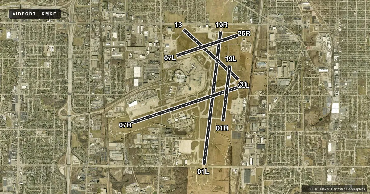
Runways & pattern
Full pagePattern entry · RWY 19R
LEFT TRAFFIC| Runway | Heading (°M) | Length | Surface | Traffic |
|---|---|---|---|---|
| 01L/19RFavored | 3° / 183° | 9,990 ft | ASPH-CONC | Standard L |
| 07R/25L | 68° / 248° | 8,300 ft | ASPH-CONC | Standard L |
| 13/31 | 128° / 308° | 5,537 ft | ASPH-CONC | Standard L |
| 07L/25R | 68° / 248° | 4,797 ft | ASPH-CONC | Standard L |
| 01R/19L | 3° / 183° | 4,182 ft | ASPH-CONC | Standard L |
Runway end performance
| End | TORA | TODA | ASDA | LDA | VGSI | Approach lights | Obstruction |
|---|---|---|---|---|---|---|---|
| 01L | 9,990' | 9,990' | 9,380' | 9,080' | PAPI 4-box right(3°) | ALSF2 | 82', tree, 3758' from thr, 985' R of cntrln, slope 44 |
| 19R | 9,990' | 9,990' | 9,990' | 9,205' | PAPI 4-box right(3°) | MALSR | 6', fence, 249' from thr, 404' R of cntrln, slope 8 |
| 07R | 8,300' | 8,300' | 8,012' | 8,012' | PAPI 4-box left(3°) | MALSR | 80', tree, 3220' from thr, 305' R of cntrln, slope 37 |
| 25L | 8,300' | 8,300' | 8,300' | 7,867' | PAPI 4-box left(3°) | — | 41', pole, 456' from thr, 464' R of cntrln, slope 8 |
| 13 | 5,537' | 5,537' | 5,537' | 4,797' | PAPI 4-box left(3°) | — | 33', pole, 816' from thr, 69' R of cntrln, slope 18 |
| 31 | 5,537' | 5,537' | 5,537' | 5,152' | PAPI 4-box right(3°) | — | 42', rr, 626' from thr, 295' R of cntrln, slope 10 |
| 07L | 4,797' | 4,797' | 4,797' | 4,797' | PAPI 4-box left(3°) | — | 44', tree, 1298' from thr, 187' R of cntrln, slope 24 |
| 25R | 4,797' | 4,797' | 4,797' | 4,797' | PAPI 4-box right(3°) | — | 77', pole, 1727' from thr, 195' R of cntrln, slope 19 |
| 01R | 4,182' | 4,182' | 4,182' | 4,182' | — | — | — |
| 19L | 4,182' | 4,182' | 4,182' | 4,182' | — | — | 125', tree, 4336' from thr, 463' R of cntrln, slope 33 |
Declared distances in feet. TORA = takeoff run available, TODA = takeoff distance, ASDA = accelerate-stop, LDA = landing distance.
Airport sketch
Runways drawn to scale from FAA survey coordinates, rendered over satellite imagery. Not for navigation.
Approaches & charts
ILS · 4
Services on the field
Fuel grades, oxygen, maintenance, ramp storage and lighting — as declared to the FAA by the airport operator.
Fuel & services
- Fuel
- 100LLA
- Oxygen (bottled)
- Not available
- Oxygen (bulk)
- High pressure
- Airframe repair
- Major
- Power plant repair
- Major
- Other services
- AMB,AVNCS,CARGO,CHTR,INSTR,RNTL,SALES
Ramp & ground
- Transient storage
- Hangar
- Landing fee
- No fee published
- Customs
- Not available
- Beacon schedule
- SS-SR
- Beacon
- White / Green (civil land)(WG)
- Wind indicator
- Lighted
- Segmented circle
- No
Fuel & FBOs
Cheapest 100LL and Jet A on the field and nearby. Always confirm with the FBO before taxi.
Airport notes
Surface conditions, obstructions, local procedures, lighting outages and other notes published with each FAA cycle.
General notes
- RY 07L/25R CLSD TO ALL JET ACFT.
- RY 13/31 CLSD JET ACFT, UNLESS PMSN FROM TWR OR AMGR 414-747-5325.
- TRNG FLGTS INVOLVING SUCCESSIVE USE OF ANY RY PROHIBITED 2200-0600.
- RWY 13/31 & 07L/25R CLSD EXC LGT WT SNGL ENG ACFT 0400-1200Z DLY.
- BIRDS ON & INVOF ARPT.
- PREFERRED USAGE BY ACFT BTN 2200-0600 IS TKOF RY 19R & LNDG RY 01L.
- ALL APCHS ARE OVER NOISE SENSITIVE AREAS; ALL TURBOJET ACFT SHOULD REFRAIN FM CONDUCTING MULTI VFR TFC PATTERN APCHS & DEPS WO PRIOR APVL FM AMGR CALL C414-747-5325.
- ACFT WITH WINGSPAN GREATER THAN 175 FT CANNOT PASS SIMULTANEOUSLY ON TWY 'E' & TWY 'Z'.
- TWY F (WEST OF TWY Z) CLSD TO ACFT WITH WINGSPAN GREATER THAN OR EQUAL TO 118 FT UNLESS PERMISSION FROM ARPT DIR AT 414-747-5325.
- RY 19R TODA 8,750 FT FROM INT TWY V.
- TWY V BTN TWY D AND RY 7L/25R CLSD TO ACFT WITH WINGSPAN GREATER THAN 170 FT WHEN RY 7L/25R IN USE.
- TWY B BTN TWY V AND TWY P CLSD TO AFCT WITH WINGSPAN GREATER THAN 170 FT.
- HOLDING BAY AT RY 19R WHEN IN USE, TWY Z ADJACENT TO BAY IS LIMITED TO ACFT WITH WINGSPAN UP TO 170 FT.
- RWY 07L/25R NO ACFT 65,000 LBS OR GTR PMTD TO TAXI BTN TWY D & RWY 13/31 AND EAST OF RWY 19R UNLESS PMSN FROM AMGR.
- RWY 01R-19L CLSD EXC TAX.
- TWY S & TWY T BTN TWY R & RY 07R/25L AND RY 07R/25L BTN RY 1R/19L & TWY R CLSD DURG CAT II & III OPNS.
- HOLDING BAY AT RY 01L CLSD EXCP ACFT WITH WINGSPAN LESS THAN 118 FT.
- TWY A CLSD BTN TWY A4 AND TWY A5 TO ACFT WITH WINGSPAN GREATER THAN OR EQUAL TO 214' UNLESS PERMISSION FROM ARPT MGR 414-747-5325
- ALL ACFT PUSHBACKS FM GATES C20, C21, C22, C23, D39 D41 D43, D45, D48, D51, D53, D54, D55, RQR CLNC FM GC. PUSHBACKS FM ALL OTR GATES ARE AT RAMP/ PILOT DISCRETION; CTC GC WHEN READY TO TAXI.
- TWY C CLSD BTWN APCH END OF RWY 7L AND WEST RAMP NORTH TXL TO ACFT WITH WINGSPAN GTR THAN OR EQUAL TO 118 FT UNLESS PMSN FM ARPT MGR 414-747-5325.
- DEICE PAD FOR RWY 07R NOT AUTH FOR THRU TAXI.
- TWY B BTN TWY R AND 750' WEST OF TWY R CLSD TO ACFT WINGSPAN MORE THAN 118 FT EXC PPR 414-747-5325.
- TWY A BTN TWY R AND TWY A1 CLSD TO ACFT WINGSPAN MORE THAN 171 FT EXC PPR 414-747-5325.
- TWY A CLSD FM TWY R TO TWY E AND TWY E CLSD FM TWY T TO TWY E1 AND TWY T CLSD N OF RWY 07R/25L, AND TWY M CLSD FM TWY E TO RWY 01R/19L TO ACFT WITH TAIL HGT GTR THAN 54.5 FT DURG CAT II AND CAT III OPS.
- ACFT ARE NOT PERMITTED TO MAKE LEFT TURN ONTO TWY E WHEN EXITING TWY E2.
- TWY F (E OF RWY 19R), TWY H, TWY J, AND TWY P CLSD TO ACFT WITH WINGSPAN GTR THAN 78 FT UNLESS PMSN FM AMGR AT 414-747-5325.
- ANG: PPR ALL ACFT 48HR PN, CTC AFLD MGMT DSN 580-8241, C414-944-8241. AFLD MGMT HR 1200Z-2030Z++ MON-THURS, CLSD HOL, FRI-SUN EXC UNIT TMG. MAINT OPS (MOCC) FREQ - 379.85. ANY MDS (OTHER THAN KC-135) LTD TO STD TRAN MARSHALLING AND PRK. NO TECH DATA AVBL FOR TRAN MAINT. FUEL AND AGE SUPPORT AVBL FOR SELF-SVC. NO ADNL CONFIGN ITEMS SUPPORTED SUCH AS LANTIRN PODS, EDM PODS, ETC. ANG: EOR FAC, ACFT SHELTERS/REVETMENTS UNAVBL. APN HAS LTD STATIC GND POINTS AND TIE DOWN POINTS. FLEET SVC/HAZ CARGO CLASS 1.1., 1.2.1, 1.2.3. PRKG UNAVBL. PRE-COORD ALL TRANSPORTATION REQUIREMENTS AND HAZ CARGO WITH PPR REQ. CTC UPSET CTL ON 321.0 30 MIN PRIOR TO LDG. NSTD MRK ON APN FOR WINGTIP CLNC USED BY BASE ASGND ACFT, AND VEHICLE PRKG LINES PAINTED ON SE CORNER.
Fuel notes
- 100LLSERVICE-FUEL: A++ (MIL ANG)
Runway surface & condition
- 01L/19RPCR VALUE: 1280/R/C/W/T
- 01R/19LPCR VALUE: 1540/R/C/W/T
- 07L/25RPCR VALUE: 370/F/B/X/T
- 07R/25LPCR VALUE: 1460/R/C/W/T
- 13/31PCR VALUE: 580/R/C/W/T
- 07L/25RRWY 07L/25R NOT AVBL FOR PART 121/PART 380 OPS WITH SKED PAX CARRYING OPS MORE THAN 9 PAX SEATS AND NON-SKED PAX CARRYING OPS MORE THAN 30 PAX SEATS.
Approach & departure obstructions
- 19RFENCE 148 FT FM THLD; 391 FT R OF CNTRLN.
- 07LUNUSBL BYD 9 DEGS RIGHT AND LEFT OF CNTRLN.
- 13APCH RATIO 27:1 TO DSPLCD THLD; 87 FT TREE 2375 FT TO DSPLCD THLD; 490 FT LEFT.
- 19RAPCH RATIO 36:1 TO DSPLCD THLD; 100 FT TREE 3641 FT TO DSPLCD THLD; 901 FT RIGHT.
- 25LAPCH RATIO 29:1 TO DSPLCD THLD; 39 FT POLE, 1140 FT TO DSPLCD THLD; 544 FT L.
- 31APCH RATIO 27:1 TO DSPLCD THLD; 42 FT RR 1160 FT TO DSPLCD THLD; 290 FT R.
Other notes
- ARFF INDEX D EQUIP AVBL UPON REQUEST.
- MANAGEREMAIL ADDRESS: BDRANZIK@MITCHELLAIRPORT.COM (ALL LOWER CASE)
VFR map & nearby airports
VFR sectional. Tap any ICAO chip to open that airport.
Key facts · KMKE
Answer card- ICAO
- KMKE
- Name
- GENERAL MITCHELL INTL
- Location
- MILWAUKEE, WISCONSIN
- Elevation
- 728.4 ft MSL
- Traffic pattern altitude
- 1,728.4 ft MSL (1,000 AGL)
- Control tower
- Towered · 24
- Total runways
- 5
- Longest runway
- 01L/19R · 9,990 ft
- Published ILS approaches
- 4
- Published frequencies
- 21
- Magnetic variation
- 4°
- Current flight rules
- VFR
- Current wind
- 200° at 12 kt
- Favored runway now
- RWY 19R
General Mitchell Intl is in Milwaukee, Wisconsin. The field elevation is 728.4 ft MSL. It has 5 runways. The longest is 9,990 ft on 01L/19R. The tower is open 24 hours. There are 4 ILS approaches, with ILS service on runway ends 01L, 07R, 19R and 25L.
Pattern altitude is not published in the facts. Use standard traffic pattern planning for light piston aircraft unless the current Chart Supplement says otherwise. The airport sits in a busy metro area, so expect a controlled environment. Plan to stay sharp on taxi instructions. Published remarks also matter here. Several taxiways have wing span limits or closures during Category II and III operations. Runway 13/31 is closed to jet aircraft unless you get permission. There is also an obstruction note on 13 and 19R, so brief the approach carefully if you are using those ends.
On field FBOs are Avflight Milwaukee, Signature Aviation and Jet Aviation Milwaukee. All three carry 100LL, Jet A and Jet A Prist. For larger aircraft, some taxiways and gates have specific restrictions. Check the current Chart Supplement. Coordinate with ground or the airport operator if your aircraft is near the published wingspan or tail height limits.