METAR & TAF KMWC
Current METAR
Observed 09:35Z
KMWC 270935Z AUTO 00000KT 2SM BR OVC002 25/25 A2984 RMK AO2
- Wind
- 000° @ 0 kt
- Visibility
- 2 SM
- Temp / Dew
- 25°C / 25°C
- Altimeter
- 29.84 inHg
- Clouds
- OVC
- Density alt
- 2,223 ft
- Ceiling
- 200 ft AGL
- Rules
- LIFR
Airport info & contacts
Manager on record, flight service, ARTCC, attendance schedule and pattern altitude — published by the FAA and refreshed every 28 days.
Location
- From city
- 5 NM NW
- VFR sectional
- CHICAGO
- ARTCC
- ZAU · CHICAGO
- NOTAM facility
- MWC (NOTAM-D)
Airport manager
- Name
- BRIAN DRANZIK
- Phone
- 414-747-5775
- Address
- 5300 S HOWELL, MILWAUKEE WI 53207
Flight service · Hours
- FSS GRB
- GREEN BAY1-800-WX-BRIEF
- Attendance
- 0800-1600
Frequencies
Tap any row to copy the frequency to your clipboard.
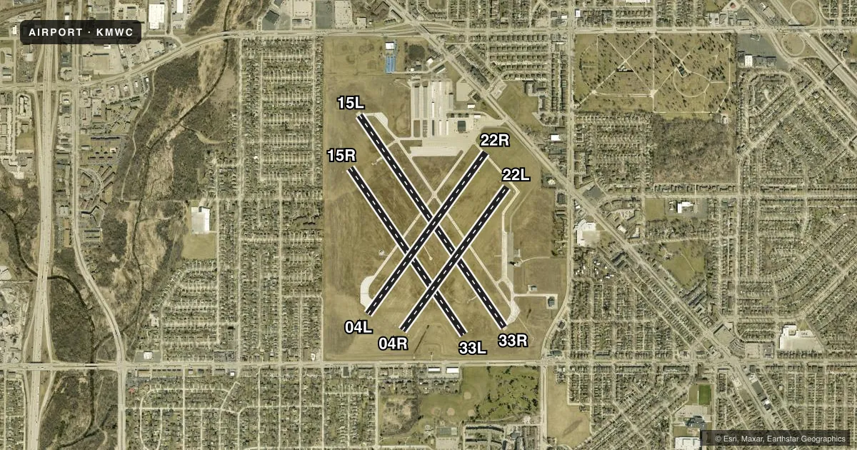
Runways & pattern
Full pagePattern entry · RWY 15L
LEFT TRAFFIC| Runway | Heading (°M) | Length | Surface | Traffic |
|---|---|---|---|---|
| 15L/33R | 144° / 324° | 4,107 ft | ASPH | Standard L |
| 15R/33L | 143° / 323° | 3,231 ft | TURF | Standard L |
| 04L/22R | 34° / 214° | 3,203 ft | ASPH | Standard L |
| 04R/22L | 34° / 214° | 2,840 ft | TURF | Standard L |
Runway end performance
| End | TORA | TODA | ASDA | LDA | VGSI | Approach lights | Obstruction |
|---|---|---|---|---|---|---|---|
| 15L | — | — | — | — | PAPI 4-box right(3°) | — | — |
| 33R | — | — | — | — | PAPI 4-box left(4°) | — | 35', tree, 830' from thr, 25' R of cntrln, slope 18 |
| 33L | — | — | — | — | — | — | 50', tree, 800' from thr, 50' R of cntrln, slope 16 |
| 04L | — | — | — | — | VASI 4-box left(4°) | — | — |
| 22R | — | — | — | — | VASI 4-box left(4°) | — | 29', tree, 700' from thr, 250' R of cntrln, slope 17 |
| 04R | — | — | — | — | — | — | 50', trees, 915' from thr, 0' R of cntrln, slope 14 |
| 22L | — | — | — | — | — | — | 53', trees, 800' from thr, 150' R of cntrln, slope 15 |
Declared distances in feet. TORA = takeoff run available, TODA = takeoff distance, ASDA = accelerate-stop, LDA = landing distance.
Airport sketch
Runways drawn to scale from FAA survey coordinates, rendered over satellite imagery. Not for navigation.
Approaches & charts
ILS · 1
Services on the field
Fuel grades, oxygen, maintenance, ramp storage and lighting — as declared to the FAA by the airport operator.
Fuel & services
- Fuel
- 100LLA+
- Oxygen (bottled)
- HIGH/LOW
- Oxygen (bulk)
- HIGH/LOW
- Airframe repair
- Major
- Power plant repair
- Major
- Other services
- CHTR,INSTR,RNTL,SALES
Ramp & ground
- Transient storage
- Tie-down
- Hangar
- Landing fee
- No fee published
- Customs
- Not available
- Lighting schedule
- SEE RMK
- Beacon schedule
- SS-SR
- Beacon
- White / Green (civil land)(WG)
- Wind indicator
- Yes
- Segmented circle
- No
Fuel & FBOs
Cheapest 100LL and Jet A on the field and nearby. Always confirm with the FBO before taxi.
Airport notes
Surface conditions, obstructions, local procedures, lighting outages and other notes published with each FAA cycle.
General notes
- BCN ELEV 797' MSL.
- TURF RYS 04R/22L & 15R/33L & ALL TURF TWYS CLSD 15 OCT - 1 MAY.
- BIRDS ON & INVOF ARPT.
- CONDS UNMON MON-FRI 1530-0630, SAT, SUN, OR FED HOLS.
- DO NOT MISTAKE TWY B & C FOR LDG/TKOF SFCS.
- LOSS OF RDO RECEPTION OCRS IN & ARND HNGRS N OF N RAMP. ACFT SHOULD REPOSITION TO N RAMP TO RCV CLNC & TAXI INSTRS.
Lighting notes
- WHEN ATCT CLSD, MIRL RWY 15L/33R PRESET TO LOW SS-SR; TO INCR INTST AND ACTVT REIL RWY 04L, 15L, 22R, & 33R; PAPI RWY 15L & 33R; VASI RWY 04L & 22R; AND MIRL RWY 04L/22R - CTAF.
Approach & departure obstructions
- 04RMKD BY WHITE TFC CONES.
- 15RMKD BY WHITE TFC CONES.
- 22LMKD BY WHITE TFC CONES.
- 33LMKD BY WHITE TFC CONES.
- 04LWHEN VASI OTS, RWY CLSD TO LDG SS-SR.
- 22RWHEN VASI OTS, RWY CLSD TO LDG SS-SR.
- 33RUNUSBL BYD 8 DEGS RIGHT OF CNTRLN. WHEN PAPI OTS, RWY CLSD TO LDG SS-SR.
Other notes
- MANAGEREMAIL ADDRESS: BDRANZIK@MITCHELLAIRPORT.COM (ALL LOWER CASE)
VFR map & nearby airports
VFR sectional. Tap any ICAO chip to open that airport.
Key facts · KMWC
Answer card- ICAO
- KMWC
- Name
- LAWRENCE J TIMMERMAN
- Location
- MILWAUKEE, WISCONSIN
- Elevation
- 744.8 ft MSL
- Traffic pattern altitude
- 1,744.8 ft MSL (1,000 AGL)
- Control tower
- Towered · 0700-2100
- Total runways
- 4
- Longest runway
- 15L/33R · 4,107 ft
- Published ILS approaches
- 1
- Published frequencies
- 8
- Magnetic variation
- 2°
- Current flight rules
- LIFR
- Current wind
- 000° at 0 kt
- Favored runway now
- –
Lawrence J Timmerman Airport sits in Milwaukee, Wisconsin. Field elevation is 744.8 ft MSL. The airport has 4 runways. The longest is runway 15L/33R at 4,107 ft. It is a towered field. Tower hours are 0700-2100. One ILS approach is published for runway 15L.
Pattern altitude is not published. Use standard 1,000 ft AGL for light piston traffic unless ATC or the current Chart Supplement says otherwise. Spring City Aviation is on the field. It carries 100LL and Jet A. Call them at (414) 461-3222 for current service details. Published remarks matter here. Turf runways 04R/22L and 15R/33L, plus turf taxiways, are closed from October 15 to May 1. White cones mark several turf runway ends. Birds are reported on and near the airport. Do not confuse taxiways B and C with landing or takeoff surfaces.
This is a busy Milwaukee-area airport with mixed asphalt and turf surfaces. Check the current Chart Supplement for any noise or operational restrictions before you go. Also note that conditions are unmonitored during certain off-hours and on weekends or holidays. If you are arriving when the tower is closed, review the lighting notes before departure so you know how to activate the runway lights and approach lighting from CTAF.