METAR & TAF 35W
35W does not publish a METAR.
Showing the nearest reporting station: KETB (WEST BEND MUNI) · 11.4 NM away. Conditions at 35W may differ.
METAR · KETB
Observed 05:35Z
KETB 270535Z AUTO 00000KT 5SM BR CLR 22/22 A2984 RMK AO2
- Wind
- 000° @ 0 kt
- Visibility
- 5 SM
- Temp / Dew
- 22°C / 22°C
- Altimeter
- 29.84 inHg
- Clouds
- CLR
- Density alt
- 1,874 ft
- Ceiling
- Unlimited
- Rules
- MVFR
Airport info & contacts
Manager on record, flight service, ARTCC, attendance schedule and pattern altitude — published by the FAA and refreshed every 28 days.
Location
- From city
- 2 NM N
- VFR sectional
- CHICAGO
- ARTCC
- ZAU · CHICAGO
- NOTAM facility
- GRB
Airport manager
- Name
- TOM DIDIER
- Phone
- 414-881-3290
- Address
- 4576 COUNTY RD KW, PORT WASHINGTON WI 53074
Flight service · Hours
- FSS GRB
- GREEN BAY1-800-WX-BRIEF
- Attendance
- Unattended
Frequencies
Tap any row to copy the frequency to your clipboard.
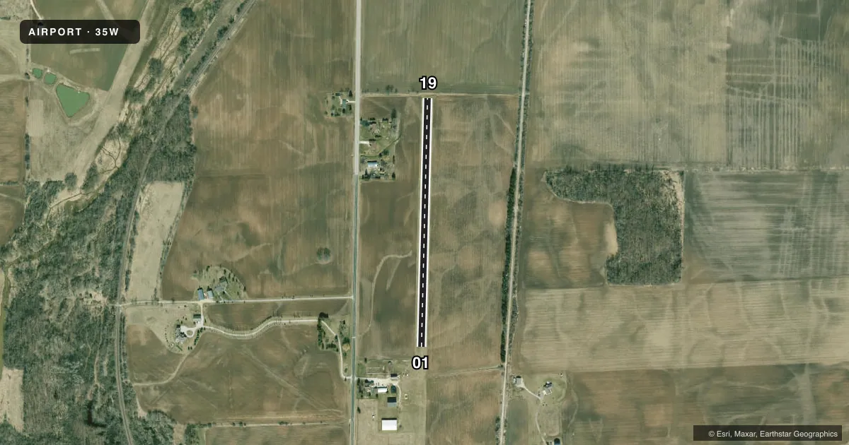
Runways & pattern
Full pagePattern entry · RWY 01
LEFT TRAFFICAirport sketch
Runways drawn to scale from FAA survey coordinates, rendered over satellite imagery. Not for navigation.
Approaches & charts
Services on the field
Fuel grades, oxygen, maintenance, ramp storage and lighting — as declared to the FAA by the airport operator.
Fuel & services
- Fuel
- Not available
- Oxygen (bottled)
- Not available
- Oxygen (bulk)
- Not available
- Airframe repair
- Not available
- Power plant repair
- Not available
Ramp & ground
- Transient storage
- Tie-down
- Landing fee
- No fee published
- Wind indicator
- Yes
- Segmented circle
- No
Fuel & FBOs
Cheapest 100LL and Jet A on the field and nearby. Always confirm with the FBO before taxi.
Airport notes
Surface conditions, obstructions, local procedures, lighting outages and other notes published with each FAA cycle.
General notes
- CFM SFC CONDS, CTC AMGR.
Approach & departure obstructions
- 01MKD WITH YELLOW CONES.
- 19MKD WITH YELLOW CONES.
Other notes
- MANAGERTOM@TOMDIDIER.COM.
VFR map & nearby airports
VFR sectional. Tap any ICAO chip to open that airport.
Key facts · 35W
Answer card- ICAO
- 35W
- Name
- PORT WASHINGTON/DIDIER FLD
- Location
- PORT WASHINGTON, WISCONSIN
- Elevation
- 754 ft MSL
- Traffic pattern altitude
- 1,754 ft MSL (1,000 AGL)
- Control tower
- Non-towered (use CTAF)
- Total runways
- 1
- Longest runway
- 01/19 · 2,000 ft
- Published ILS approaches
- 0
- Published frequencies
- 1
- Magnetic variation
- –
- Current flight rules
- MVFR
- Current wind
- 000° at 0 kt
- Favored runway now
- –