METAR & TAF 02C
02C does not publish a METAR.
Showing the nearest reporting station: KUES (WAUKESHA COUNTY) · 3.9 NM away. Conditions at 02C may differ.
METAR · KUES
Observed 14:45Z
KUES 271445Z 13010KT 3SM BR OVC005 28/23 A2976
- Wind
- 130° @ 10 kt
- Visibility
- 3 SM
- Temp / Dew
- 28°C / 23°C
- Altimeter
- 29.76 inHg
- Clouds
- OVC
- Density alt
- 2,805 ft
- Ceiling
- 500 ft AGL
- Rules
- IFR
Airport info & contacts
Manager on record, flight service, ARTCC, attendance schedule and pattern altitude — published by the FAA and refreshed every 28 days.
Location
- From city
- 3 NM E
- VFR sectional
- CHICAGO
- Pattern altitude
- 800 ft AGL · 1,644 ft MSL
- ARTCC
- ZAU · CHICAGO
- NOTAM facility
- GRB (NOTAM-D)
Airport manager
- Name
- MATT BYRNE
- Phone
- 262-781-4213
- Address
- 21500 GUMINA DR, BROOKFIELD WI 53072
Flight service · Hours
- FSS GRB
- GREEN BAY1-800-WX-BRIEF
- Attendance
- IREG
Frequencies
Tap any row to copy the frequency to your clipboard.
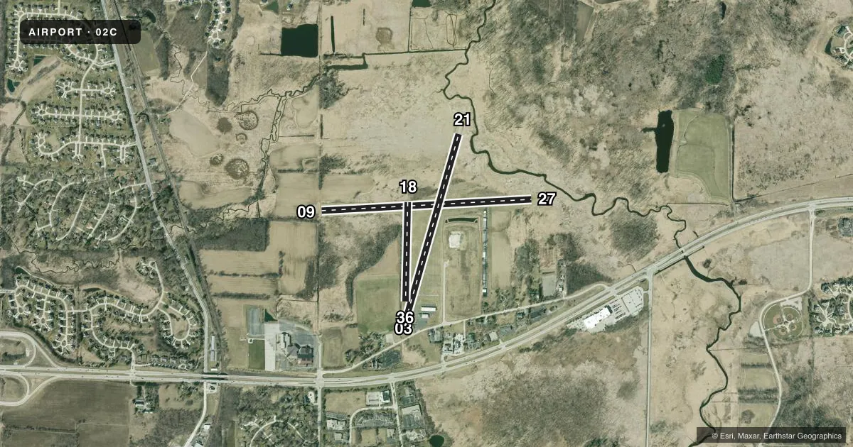
Runways & pattern
Full pagePattern entry · RWY 09
LEFT TRAFFIC| Runway | Heading (°M) | Length | Surface | Traffic |
|---|---|---|---|---|
| 09/27Favored | 87° / 267° | 3,387 ft | TURF | Standard L |
| 03/21 | 16° / 196° | 2,994 ft | ASPH | Standard L |
| 18/36 | 181° / 1° | 1,602 ft | TURF | Standard L |
Runway end performance
| End | TORA | TODA | ASDA | LDA | VGSI | Approach lights | Obstruction |
|---|---|---|---|---|---|---|---|
| 09 | — | — | — | — | — | — | 30', tree, 140' from thr, 90' R of cntrln, slope 4 |
| 27 | — | — | — | — | — | — | 82', trees, 1400' from thr, 0' R of cntrln, slope 17 |
| 03 | — | — | — | — | — | — | 10', brush, 200' from thr, 65' R of cntrln, slope 1 |
| 21 | — | — | — | — | — | — | 8', brush, 200' from thr, 50' R of cntrln, slope 1 |
| 18 | — | — | — | — | — | — | 55', tree, 63' from thr, 124' R of cntrln, slope 1 |
| 36 | — | — | — | — | — | — | 15', brush, 0' from thr, 120' R of cntrln, slope 1 |
Declared distances in feet. TORA = takeoff run available, TODA = takeoff distance, ASDA = accelerate-stop, LDA = landing distance.
Airport sketch
Runways drawn to scale from FAA survey coordinates, rendered over satellite imagery. Not for navigation.
Approaches & charts
Services on the field
Fuel grades, oxygen, maintenance, ramp storage and lighting — as declared to the FAA by the airport operator.
Fuel & services
- Fuel
- 100LLUL91
- Oxygen (bottled)
- Not available
- Oxygen (bulk)
- Not available
- Airframe repair
- Not available
- Power plant repair
- Not available
- Other services
- INSTR,RNTL
Ramp & ground
- Transient storage
- Tie-down
- Hangar
- Landing fee
- No fee published
- Customs
- Not available
- Lighting schedule
- SEE RMK
- Beacon schedule
- SS-SR
- Beacon
- White / Green (civil land)(WG)
- Wind indicator
- Lighted
- Segmented circle
- Yes
Fuel & FBOs
Cheapest 100LL and Jet A on the field and nearby. Always confirm with the FBO before taxi.
Airport notes
Surface conditions, obstructions, local procedures, lighting outages and other notes published with each FAA cycle.
General notes
- RWY 03 & 36 ACFT OPS CANNOT SEE RWY 27 ACFT OPS.
- RWY 09/27 & 18/36 NOT PLOWED. DEC 1 THRU APR 15. OPEN FOR SKI EQUIPPED ACFT AND WHEELED ACFT WHEN GND FROZEN. CRM CONDS & SNOW REMOVAL FOR RWY 03/21 WITH AMGR.
- FOR CD CTC CHICAGO ARTCC AT 630-906-8921.
Lighting notes
- ACTVT MIRL RWY 03/21 - CTAF.
Runway surface & condition
- 03/21DTHR LGTS G AND W, END OF PAVEMENT LGTS RED.
Approach & departure obstructions
- 0310 FT BRUSH 0-200 FT FM RWY END; 120 - 60 FT L.
- 2110 FT BRUSH 0-200 FT FM RWY END; 50 FT L & 80 FT R.
- 03MRKGS FADED.
- 21MRKGS FADED.
- 09MKD WITH YELLOW CONES.
- 18MKD WITH WHITE AND BLACK BARRELS.
- 27MKD WITH YELLOW CONES.
- 36MKD WITH YELLOW CONES.
- 03APCH RATIO 20:1 TO DTHR.
- 21APCH RATIO 20:1 TO DTHR.
Other notes
- MANAGERNINER614WHISKEY@YAHOO.COM.
- MANAGERADNL FONE 414-406-3119.
VFR map & nearby airports
VFR sectional. Tap any ICAO chip to open that airport.
Key facts · 02C
Answer card- ICAO
- 02C
- Name
- CAPITOL DRIVE
- Location
- BROOKFIELD, WISCONSIN
- Elevation
- 844.2 ft MSL
- Traffic pattern altitude
- 1,644.2 ft MSL (800 AGL)
- Control tower
- Non-towered (use CTAF)
- Total runways
- 3
- Longest runway
- 09/27 · 3,387 ft
- Published ILS approaches
- 0
- Published frequencies
- 2
- Magnetic variation
- –
- Current flight rules
- IFR
- Current wind
- 130° at 10 kt
- Favored runway now
- RWY 09
Capitol Drive Airport (02C) is in Brookfield, Wisconsin. The field elevation is 844.2 ft MSL. It has three runways. The longest is runway 09/27 at 3,387 ft. There is no control tower. CTAF and UNICOM are both 122.7. No ILS approaches are published here.
Pattern altitude is 800 ft AGL, which is 1,644.2 ft MSL. That is the number to fly here. Brookfield Aero is on the field. It carries 100LL and MOGAS. Call them at (262) 781-4213 for current service details. The airport manager can also be reached at 414-406-3119.
There are a few operational points to know before you go. Runways 09/27 and 18/36 are not plowed from December 1 through April 15. They are open for ski-equipped aircraft and wheeled aircraft when the ground is frozen. Confirm runway 03/21 snow removal with the airport manager. Runway 03/21 has CTAF-activated medium intensity lights. Runway 21 has faded markings. Brush is reported near the approach end of runways 03 and 21. The approach slope to the displaced threshold on those ends is 20 to 1. For clearance delivery, contact Chicago ARTCC at 630-906-8921.