METAR & TAF W11
W11 does not publish a METAR.
Showing the nearest reporting station: KRYV (WATERTOWN MUNI) · 11.0 NM away. Conditions at W11 may differ.
METAR · KRYV
Observed 15:35Z
KRYV 271535Z AUTO 16007KT 10SM -TSRA SCT019 BKN039 OVC055 26/26 A2968 RMK AO2 LTG DSNT ALQS P0005 T02590259
- Wind
- 160° @ 7 kt
- Visibility
- 10 SM
- Temp / Dew
- 26°C / 26°C
- Altimeter
- 29.68 inHg
- Clouds
- OVC
- Density alt
- 2,663 ft
- Ceiling
- 3,900 ft AGL
- Rules
- VFR
Airport info & contacts
Manager on record, flight service, ARTCC, attendance schedule and pattern altitude — published by the FAA and refreshed every 28 days.
Location
- From city
- 1 NM SW
- VFR sectional
- CHICAGO
- ARTCC
- ZAU · CHICAGO
- NOTAM facility
- GRB
Airport manager
- Name
- NICK BETTENDORF
- Phone
- 262-443-6462
- Address
- 200 MAIN ST., SULLIVAN WI 53178
Flight service · Hours
- FSS GRB
- GREEN BAY1-800-WX-BRIEF
- Attendance
- MON-FRI · 0900-1700
Frequencies
Tap any row to copy the frequency to your clipboard.
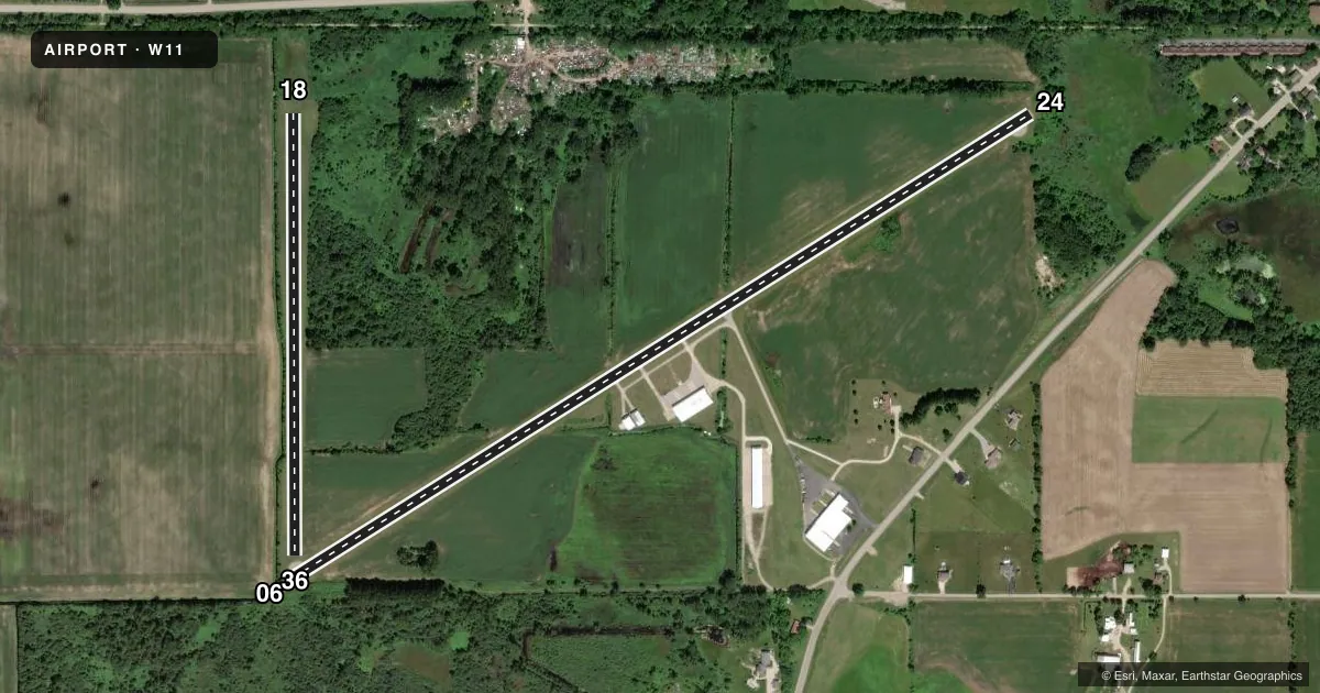
Runways & pattern
Full pagePattern entry · RWY 18
LEFT TRAFFIC| Runway | Heading (°M) | Length | Surface | Traffic |
|---|---|---|---|---|
| 06/24 | 58° / 238° | 4,558 ft | ASPH | Standard L |
| 18/36Favored | 180° / 360° | 2,300 ft | TURF | Standard L |
Runway end performance
| End | TORA | TODA | ASDA | LDA | VGSI | Approach lights | Obstruction |
|---|---|---|---|---|---|---|---|
| 06 | — | — | — | — | — | — | 35', trees, 300' from thr, 75' R of cntrln, slope 2 |
| 24 | — | — | — | — | — | — | 30', tree, 206' from thr, 25' R of cntrln, slope 0 |
| 18 | — | — | — | — | — | — | 25', tree, 160' from thr, 110' R of cntrln, slope 6 |
| 36 | — | — | — | — | — | — | 35', tree, 225' from thr, 60' R of cntrln, slope 6 |
Declared distances in feet. TORA = takeoff run available, TODA = takeoff distance, ASDA = accelerate-stop, LDA = landing distance.
Airport sketch
Runways drawn to scale from FAA survey coordinates, rendered over satellite imagery. Not for navigation.
Approaches & charts
Services on the field
Fuel grades, oxygen, maintenance, ramp storage and lighting — as declared to the FAA by the airport operator.
Fuel & services
- Fuel
- 100LL
- Airframe repair
- Minor
- Power plant repair
- Minor
- Other services
- INSTR,RNTL
Ramp & ground
- Transient storage
- Tie-down
- Hangar
- Lighting schedule
- SEE RMK
- Wind indicator
- Yes
- Segmented circle
- No
Fuel & FBOs
Cheapest 100LL and Jet A on the field and nearby. Always confirm with the FBO before taxi.
Airport notes
Surface conditions, obstructions, local procedures, lighting outages and other notes published with each FAA cycle.
General notes
- FOR CD CTC CHICAGO ARTCC AT 630-906-8921.
- DEER ON & INVOF ARPT.
Lighting notes
- ACTVT LIRL RWY 06/24 - 3 CLICKS CTAF.
Approach & departure obstructions
- 0620 FT TREES 85 FT FM RWY END ON CNTRLN.
- 2430 FT TREES 170 FT FM RWY END 30 FT R; 15 FT BRUSH 30 FT FM RWY END 60 FT L.
- 18MKD WITH YELLOW CONES.
- 36MKD WITH YELLOW CONES.
- 06APCH RATIO 20:1 TO DTHR.
- 18APCH RATIO 20:1 TO DTHR.
- 24APCH RATIO 20:1 TO DTHR.
Other notes
- PRVD A 20:1 APCH CLNC OVER OBSTNS; REF BE MADE TO FAA ADVISORY CIRCULAR DURING CONSTRUCTION; AREA 125 FT EITHER SIDE FM CTR & AREA 300 FT OFF EITHER RY BE FREE OF OBSTNS.
VFR map & nearby airports
VFR sectional. Tap any ICAO chip to open that airport.
Key facts · W11
Answer card- ICAO
- W11
- Name
- LAKE COUNTRY
- Location
- SULLIVAN, WISCONSIN
- Elevation
- 843 ft MSL
- Traffic pattern altitude
- 1,843 ft MSL (1,000 AGL)
- Control tower
- Non-towered (use CTAF)
- Total runways
- 2
- Longest runway
- 06/24 · 4,558 ft
- Published ILS approaches
- 0
- Published frequencies
- 1
- Magnetic variation
- 0°
- Current flight rules
- VFR
- Current wind
- 160° at 7 kt
- Favored runway now
- RWY 18
Lake Country Airport sits in Sullivan, Wisconsin. Field elevation is 843 ft MSL. The airport has two runways. The longest is 06/24 at 4,558 ft. Runway 18/36 is turf at 2,300 ft. There is no control tower. CTAF is 122.9.
No ILS approaches are published here. Pattern altitude is not published, so use 1,000 ft AGL for light piston operations unless the current FAA Chart Supplement says otherwise. The published remarks matter here. Runway 06/24 has low intensity lights that activate on 123.0. Deer are reported on and near the airport. There are also obstacle notes on the approach paths, so plan a careful look at the current Chart Supplement before you go. Runway 18 and runway 36 are marked with yellow cones.
There are no on-field FBOs listed in the facts. Contact the airport operator directly before arrival, or call the field on CTAF for current FBO availability. For clearance delivery, Chicago ARTCC is listed in the remarks. This is a non-towered field with a turf runway and a longer asphalt runway. A good radio scan and a close look at runway condition are smart here.