METAR & TAF KUES
Current METAR
Observed 12:45Z
KUES 271245Z 14008KT 1SM BR OVC002 25/24 A2983
- Wind
- 140° @ 8 kt
- Visibility
- 1 SM
- Temp / Dew
- 25°C / 24°C
- Altimeter
- 29.83 inHg
- Clouds
- OVC
- Density alt
- 2,442 ft
- Ceiling
- 200 ft AGL
- Rules
- LIFR
Airport info & contacts
Manager on record, flight service, ARTCC, attendance schedule and pattern altitude — published by the FAA and refreshed every 28 days.
Location
- From city
- 2 NM N
- VFR sectional
- CHICAGO
- ARTCC
- ZAU · CHICAGO
- NOTAM facility
- UES (NOTAM-D)
Airport manager
- Name
- KURT STANICH
- Phone
- 262-521-5250
- Address
- 2525 AVIATION DR, WAUKESHA WI 53188
Flight service · Hours
- FSS GRB
- GREEN BAY1-800-WX-BRIEF
- Attendance
- ALL
Frequencies
Tap any row to copy the frequency to your clipboard.
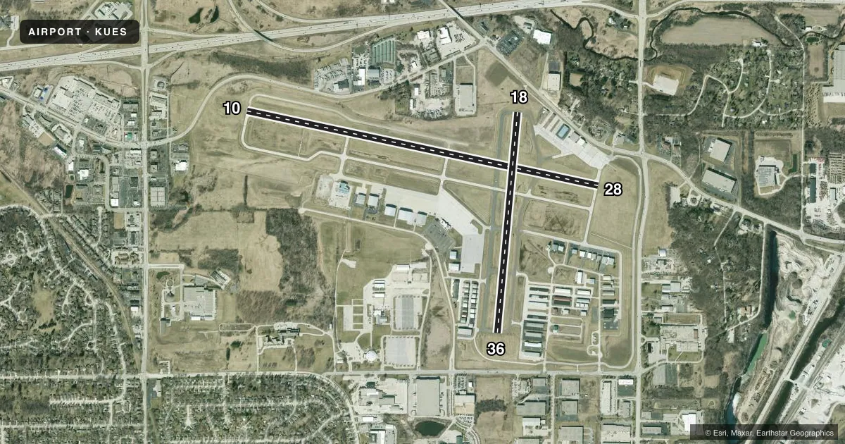
Runways & pattern
Full pagePattern entry · RWY 10
LEFT TRAFFIC| Runway | Heading (°M) | Length | Surface | Traffic |
|---|---|---|---|---|
| 10/28Favored | 101° / 281° | 5,849 ft | CONC | 28 R |
| 18/36 | 184° / 4° | 3,599 ft | ASPH | 36 R |
Runway end performance
| End | TORA | TODA | ASDA | LDA | VGSI | Approach lights | Obstruction |
|---|---|---|---|---|---|---|---|
| 10 | — | — | — | — | PAPI 4-box right(3°) | MALSR | — |
| 28 | — | — | — | — | VASI 4-box left(3.75°) | — | 75', trees, 1600' from thr, 100' R of cntrln, slope 18 |
| 18 | — | — | — | — | PAPI 2-box left(3°) | — | — |
| 36 | — | — | — | — | PAPI 2-box left(4°) | — | 50', tree, 1140' from thr, 25' R of cntrln, slope 18 |
Declared distances in feet. TORA = takeoff run available, TODA = takeoff distance, ASDA = accelerate-stop, LDA = landing distance.
Airport sketch
Runways drawn to scale from FAA survey coordinates, rendered over satellite imagery. Not for navigation.
Approaches & charts
ILS · 1
Services on the field
Fuel grades, oxygen, maintenance, ramp storage and lighting — as declared to the FAA by the airport operator.
Fuel & services
- Fuel
- 100LLA+
- Oxygen (bottled)
- High pressure
- Oxygen (bulk)
- High pressure
- Airframe repair
- Major
- Power plant repair
- Major
- Other services
- AMB,AVNCS,CHTR,INSTR,RNTL,SALES,SURV
Ramp & ground
- Transient storage
- Tie-down
- Hangar
- Landing fee
- No fee published
- Customs
- Not available
- Lighting schedule
- SEE RMK
- Beacon schedule
- SS-SR
- Beacon
- White / Green (civil land)(WG)
- Wind indicator
- Lighted
- Segmented circle
- Yes
Fuel & FBOs
Cheapest 100LL and Jet A on the field and nearby. Always confirm with the FBO before taxi.
Airport notes
Surface conditions, obstructions, local procedures, lighting outages and other notes published with each FAA cycle.
General notes
- COYOTES ON & INVOF ARPT.
- NORTH RAMP LIGHTS OUT OF SERVICE
- CALL MILWAUKEE (MKE) CLEARENCE DELIVERY 128.7 'ONLY' WHEN WAUKESHA (UES) TWR CLSD.
Lighting notes
- HIRL RWY 10/28 PRESET ON LOW INTST; TO INCR INTST & ACTVT MALSR RWY 10; REIL RWY 28, MIRL RWY 18/36 - CTAF. PAPI RWY 10 & VASI RWY 28 OPR CONSLY.
Runway surface & condition
- 10/28GROSS WT 2S-155
Other notes
- CALL 262-549-6150 FOR OXY AVBLY.
- MANAGEREMAIL ADDRESS: KSTANICH@WAUKESHACOUNTY.GOV (ALL LOWER CASE)
- MANAGERCELL PHONE: 262-424-6747
VFR map & nearby airports
VFR sectional. Tap any ICAO chip to open that airport.
Key facts · KUES
Answer card- ICAO
- KUES
- Name
- WAUKESHA COUNTY
- Location
- WAUKESHA, WISCONSIN
- Elevation
- 911.5 ft MSL
- Traffic pattern altitude
- 1,911.5 ft MSL (1,000 AGL)
- Control tower
- Towered · 0600-2100
- Total runways
- 2
- Longest runway
- 10/28 · 5,849 ft
- Published ILS approaches
- 1
- Published frequencies
- 9
- Magnetic variation
- 1°
- Current flight rules
- LIFR
- Current wind
- 140° at 8 kt
- Favored runway now
- RWY 10
Waukesha County Airport is in Waukesha, Wisconsin. Field elevation is 911.5 ft MSL. The airport has two runways. The longest is 10/28 at 5,849 ft. Runway 18/36 is 3,599 ft. The tower is open daily from 0600 to 2100. One ILS is published for runway 10.
Pattern altitude is not published. Use 1,000 ft AGL for light piston traffic unless ATC or the current Chart Supplement says otherwise. That puts the standard pattern at about 1,912 ft MSL based on the field elevation. Runway headings are magnetic. The field has a small magnetic variation of 1°.
Atlantic Aviation is on the field. It carries 100LL and Jet A. Stein's Aircraft Services is also on the field. It carries 100LL and Jet A Prist. If you need oxygen, call Atlantic Aviation first. The Chart Supplement also notes that Milwaukee clearance delivery on 128.7 is used only when Waukesha tower is closed.
There are a few operational details worth having in mind before arrival. Runway 10 uses the common traffic advisory frequency to raise lighting intensity and to activate the medium intensity approach lighting system with runway alignment indicator lights. Runway 28 has runway end identifier lights. Runway 18/36 uses medium intensity runway lights. Coyotes are reported on and near the airport. North ramp lights are out of service. This is a controlled airport near the Milwaukee area. Get the current ATIS. Expect normal tower procedures. Verify any runway lighting or ramp issues before you taxi.