METAR & TAF 62C
62C does not publish a METAR.
Showing the nearest reporting station: KBUU (BURLINGTON MUNI) · 11.8 NM away. Conditions at 62C may differ.
METAR · KBUU
Observed 13:15Z
KBUU 271315Z AUTO 17004KT 4SM OVC003 27/26 A2982 RMK AO2 T02660260 PWINO
- Wind
- 170° @ 4 kt
- Visibility
- 4 SM
- Temp / Dew
- 27°C / 26°C
- Altimeter
- 29.82 inHg
- Clouds
- OVC
- Density alt
- 2,536 ft
- Ceiling
- 300 ft AGL
- Rules
- LIFR
Airport info & contacts
Manager on record, flight service, ARTCC, attendance schedule and pattern altitude — published by the FAA and refreshed every 28 days.
Location
- From city
- 7 NM NW
- VFR sectional
- CHICAGO
- ARTCC
- ZAU · CHICAGO
- NOTAM facility
- GRB (NOTAM-D)
Airport manager
- Name
- DAVID GUNTLY
- Phone
- 414-303-6108
- Address
- 22031 SIX MILE RD, FRANKSVILLE WI 53126
Flight service · Hours
- FSS GRB
- GREEN BAY1-800-WX-BRIEF
- Attendance
- Unattended
Frequencies
Tap any row to copy the frequency to your clipboard.
Runways & pattern
Full pagePattern entry · RWY 18
LEFT TRAFFIC| Runway | Heading (°M) | Length | Surface | Traffic |
|---|---|---|---|---|
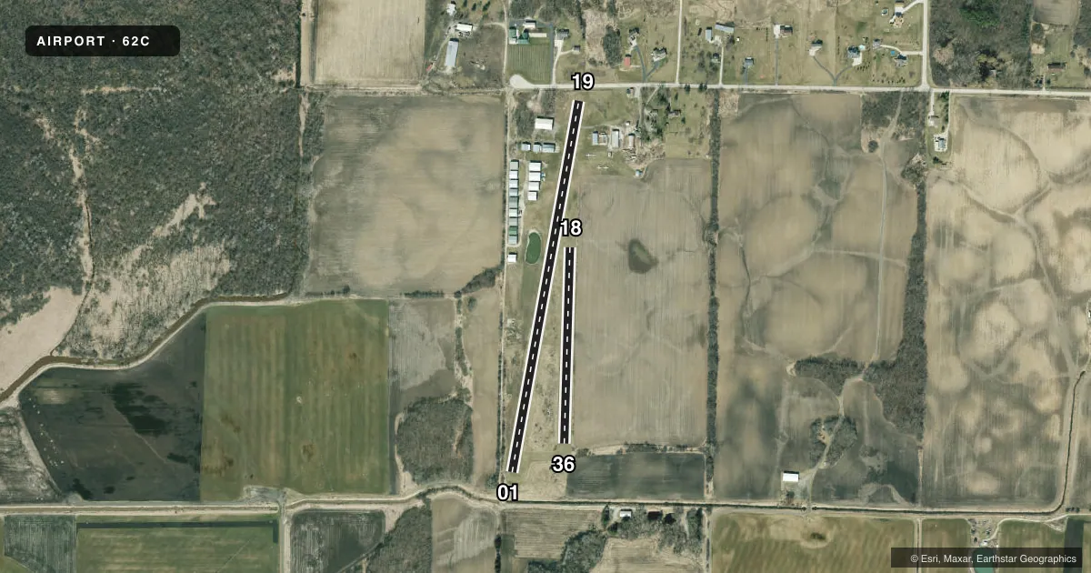
| 01/19 | 9° / 189° | 2,381 ft | TURF | Standard L |
| 18/36Favored | 181° / 1° | 1,239 ft | TURF | Standard L |
Runway end performance
| End | TORA | TODA | ASDA | LDA | VGSI | Approach lights | Obstruction |
|---|---|---|---|---|---|---|---|
| 01 | — | — | — | — | — | — | 20', brush, 0' from thr, 55' R of cntrln, slope 1 |
| 19 | — | — | — | — | — | — | 11', road, 60' from thr, 130' R of cntrln, slope 5 |
| 18 | — | — | — | — | — | — | 54', trees, 930' from thr, 175' R of cntrln, slope 17 |
| 36 | — | — | — | — | — | — | 20', brush, 70' from thr, 100' R of cntrln, slope 3 |
Declared distances in feet. TORA = takeoff run available, TODA = takeoff distance, ASDA = accelerate-stop, LDA = landing distance.
Airport sketch
Runways drawn to scale from FAA survey coordinates, rendered over satellite imagery. Not for navigation.
Approaches & charts
Services on the field
Fuel grades, oxygen, maintenance, ramp storage and lighting — as declared to the FAA by the airport operator.
Fuel & services
- Fuel
- Not available
- Oxygen (bottled)
- Not available
- Oxygen (bulk)
- Not available
- Airframe repair
- Not available
- Power plant repair
- Not available
Ramp & ground
- Transient storage
- Tie-down
- Landing fee
- No fee published
- Lighting schedule
- SEE RMK
- Wind indicator
- Yes
- Segmented circle
- No
Fuel & FBOs
Cheapest 100LL and Jet A on the field and nearby. Always confirm with the FBO before taxi.
Airport notes
Surface conditions, obstructions, local procedures, lighting outages and other notes published with each FAA cycle.
General notes
- RY 18 & 19 GND DROPS OFF RAPIDLY AT 'S' END.
- FOR CD CTC CHICAGO ARTCC AT 630-906-8921.
Lighting notes
- ACTVT LIRL RY 01/19 - CTAF.
Runway surface & condition
- 01/19RY 01/19 NSTD LIRL HAS 2 PAIRS OF LGTS EACH END.
Approach & departure obstructions
- 18MKD WITH ORANGE CONES.
- 36MKD WITH ORANGE CONES.
Other notes
- COMPATIBLE TFC PAT WITH HORNER FARMS ARPT.
- MANAGEREMAIL ADDRESS: CRAZYBIPLANE@GMAIL.COM (ALL LOWER CASE)
- 18/36ROUGH & UNDULATING ROLLING TERRAIN - CANNOT SEE ONE END FM THE OTHER.
VFR map & nearby airports
VFR sectional. Tap any ICAO chip to open that airport.
Key facts · 62C
Answer card- ICAO
- 62C
- Name
- CINDY GUNTLY MEML
- Location
- FRANKSVILLE, WISCONSIN
- Elevation
- 784 ft MSL
- Traffic pattern altitude
- 1,784 ft MSL (1,000 AGL)
- Control tower
- Non-towered (use CTAF)
- Total runways
- 2
- Longest runway
- 01/19 · 2,381 ft
- Published ILS approaches
- 0
- Published frequencies
- 1
- Magnetic variation
- 1°
- Current flight rules
- LIFR
- Current wind
- 170° at 4 kt
- Favored runway now
- RWY 18
Cindy Guntly Meml is in Franksville, Wisconsin. The field elevation is 784 ft MSL. It has two turf runways. The longest is 2,381 ft on 01/19. There is no control tower. CTAF is 122.9. No ILS approaches are published.
Pattern altitude is not published. Use the standard 1,000 ft AGL for light piston operations unless the current Chart Supplement says otherwise. That puts the usual traffic pattern at 1,784 ft MSL based on the field elevation, but verify before you fly. Runway 01/19 has low-intensity lighting that is controlled by CTAF. The runway also has two pairs of lights at each end. Runway 18/36 has rough and undulating terrain. One end cannot be seen from the other. Runway 18 and runway 19 both have ground that drops off rapidly at the south end. Runway 18 and runway 36 are marked with orange cones.
No on-field FBOs are listed. Check with the airport operator directly before arrival if you need fuel or other services. For clearance delivery, contact Chicago ARTCC at 630-906-8921. The field also notes compatible traffic patterns with Horner Farms Airport. Treat this as a small turf strip with some terrain and visibility limits on one runway. Plan your arrival with that in mind.