METAR & TAF KRAC
Current METAR
Observed 18:20Z
KRAC 271820Z AUTO 18013G21KT 10SM BKN047 BKN080 22/21 A2975 RMK AO2 LTG DSNT E-S T02220206
- Wind
- 180° @ 13G21 kt
- Visibility
- 10 SM
- Temp / Dew
- 22°C / 21°C
- Altimeter
- 29.75 inHg
- Clouds
- BKN
- Density alt
- 1,886 ft
- Ceiling
- 4,700 ft AGL
- Rules
- VFR
Airport info & contacts
Manager on record, flight service, ARTCC, attendance schedule and pattern altitude — published by the FAA and refreshed every 28 days.
Location
- From city
- 2 NM NW
- VFR sectional
- CHICAGO
- ARTCC
- ZAU · CHICAGO
- NOTAM facility
- RAC (NOTAM-D)
Airport manager
- Name
- TAMARA SANDBERG
- Phone
- 262-631-5620
- Address
- 3239 N. GREEN BAY RD, RACINE WI 53404
Flight service · Hours
- FSS GRB
- GREEN BAY1-800-WX-BRIEF
- Attendance
- 0700-1700
Frequencies
Tap any row to copy the frequency to your clipboard.
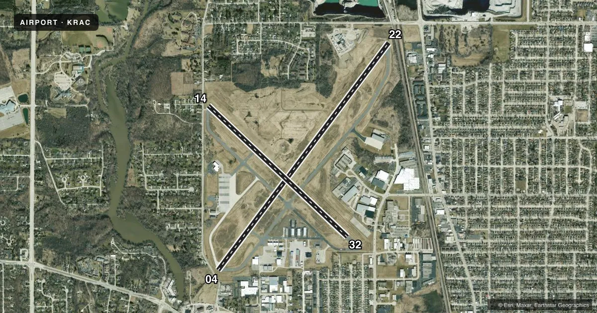
Runways & pattern
Full pagePattern entry · RWY 22
LEFT TRAFFIC| Runway | Heading (°M) | Length | Surface | Traffic |
|---|---|---|---|---|
| 04/22Favored | 35° / 215° | 6,574 ft | CONC | Standard L |
| 14/32 | 131° / 311° | 4,421 ft | ASPH | Standard L |
Runway end performance
| End | TORA | TODA | ASDA | LDA | VGSI | Approach lights | Obstruction |
|---|---|---|---|---|---|---|---|
| 04 | — | — | — | — | PAPI 4-box left(3°) | MALSF | 15', road, 200' from thr, 140' R of cntrln, slope 0 |
| 22 | — | — | — | — | PAPI 4-box left(3°) | — | 8', rr, 200' from thr, 50' R of cntrln, slope 0 |
| 14 | — | — | — | — | PAPI 4-box left(4°) | — | 15', road, 200' from thr, 15' R of cntrln, slope 0 |
| 32 | — | — | — | — | — | — | 31', tree, 770' from thr, 100' R of cntrln, slope 18 |
Declared distances in feet. TORA = takeoff run available, TODA = takeoff distance, ASDA = accelerate-stop, LDA = landing distance.
Airport sketch
Runways drawn to scale from FAA survey coordinates, rendered over satellite imagery. Not for navigation.
Approaches & charts
ILS · 1
Services on the field
Fuel grades, oxygen, maintenance, ramp storage and lighting — as declared to the FAA by the airport operator.
Fuel & services
- Fuel
- 100LLAA+
- Oxygen (bottled)
- Not available
- Oxygen (bulk)
- Not available
- Airframe repair
- Major
- Power plant repair
- Major
- Other services
- CHTR,INSTR,RNTL
Ramp & ground
- Transient storage
- Tie-down
- Hangar
- Landing fee
- Yes
- Customs
- Not available
- Lighting schedule
- SEE RMK
- Beacon schedule
- SS-SR
- Beacon
- White / Green (civil land)(WG)
- Wind indicator
- Lighted
- Segmented circle
- No
Fuel & FBOs
Cheapest 100LL and Jet A on the field and nearby. Always confirm with the FBO before taxi.
Airport notes
Surface conditions, obstructions, local procedures, lighting outages and other notes published with each FAA cycle.
General notes
- MIGRATORY WATERFOWL ON & INVOF ARPT.
- FOR CD CTC CHICAGO ARTCC AT 630-906-8921.
Lighting notes
- HIRL RWY 04/22 PRESET TO LOW SS-SR; TO INCR INTST & ACTVT MALSF RWY 04; REIL RWY 22, 14 & 32; PAPI RWY 14; HIRL RWY 04/22; MIRL RWY 14/32 - CTAF. PAPI RWY 04 & 22 OPRS CONSLY.
Approach & departure obstructions
- 0410 FT FENCE 0-90 FT FM RWY END, BOTH SIDES OF CNTRLN; 15 FT RD 0-200 FT FM RWY END, BOTH SIDES OF CNTRLN.
- 1410 FT FENCE 10-200 FT FM RWY END, BOTH SIDES OF CNTRLN; 15 FT RD 0-200 FT FM RWY END, BOTH SIDES OF CNTRLN; 50 FT TREE 110 FT FM RWY END, 175 FT R.
- 2223 FT RR 0-200 FT FM RWY END, 60-230 FT L; 20 FT TREE 10 FT FM RWY END, 130 FT L.
- 04APCH RATIO 33:1 TO DSPLCD THR; 33 FT TREE 1100 FT FM DSPLCD THR; 350 FT R.
- 14APCH RATIO 18:1 TO DSPLCD THR; 50 FT TREE 920 FT FM DSPLCD THR; 175 FT R.
- 22APCH RATIO 26:1 TO DSPLCD THR; 50 FT TREE 1340 FT FM DSPCLD THR; 150 FT R.
Other notes
- EST PRIOR TO 1959.
- LNDG FEE FOR JET ACFT.
VFR map & nearby airports
VFR sectional. Tap any ICAO chip to open that airport.
Key facts · KRAC
Answer card- ICAO
- KRAC
- Name
- BATTEN INTL
- Location
- RACINE, WISCONSIN
- Elevation
- 673.6 ft MSL
- Traffic pattern altitude
- 1,673.6 ft MSL (1,000 AGL)
- Control tower
- Non-towered (use CTAF)
- Total runways
- 2
- Longest runway
- 04/22 · 6,574 ft
- Published ILS approaches
- 1
- Published frequencies
- 5
- Magnetic variation
- 2°
- Current flight rules
- VFR
- Current wind
- 180° at 13 kt
- Favored runway now
- RWY 22
Batten Intl is in Racine, Wisconsin. The field elevation is 673.6 ft MSL. It has two runways. The longest is runway 04/22 at 6,574 ft. There is no control tower, so plan on CTAF self-announce work and standard local traffic flow. Pattern altitude is not published. Use 1,000 ft AGL for light piston traffic unless the current Chart Supplement says otherwise.
Runway 04 has an ILS. That is the only published ILS approach on the field. Runway 04/22 has high intensity lights that are preset low from sunset to sunrise. Use CTAF to increase intensity and to activate the MALSR on runway 04. Runway 14/32 has medium intensity lights. PAPI is published on runway 14. PAPI on 04 and 22 operates continuously. The field is in Racine near Lake Michigan, so expect waterfowl in and around the airport. That matters on departure and on short final.
Racine Commercial Airport Corp. is on the field. It carries 100LL, Jet A and Jet A Prist. The airport also has published obstruction notes near both runway ends. They are especially relevant on 04, 14 and 22. Check the current Chart Supplement and brief the displaced threshold details before you go in. There is also a jet landing fee noted in the published remarks.