METAR & TAF KUGN
Current METAR
Observed 16:05Z
KUGN 271605Z 17011KT 2SM -TSRA BR OVC015 26/25 A2971 RMK AO2 LTG DSNT SW-N RAB1558 TSB04 P0000 T02610250
- Wind
- 170° @ 11 kt
- Visibility
- 2 SM
- Temp / Dew
- 26°C / 25°C
- Altimeter
- 29.71 inHg
- Clouds
- OVC
- Density alt
- 2,483 ft
- Ceiling
- 1,500 ft AGL
- Rules
- IFR
Airport info & contacts
Manager on record, flight service, ARTCC, attendance schedule and pattern altitude — published by the FAA and refreshed every 28 days.
Location
- From city
- 35 NM N
- VFR sectional
- CHICAGO
- ARTCC
- ZAU · CHICAGO
- NOTAM facility
- UGN (NOTAM-D)
Airport manager
- Name
- SKIP GOSS
- Phone
- 847-244-0055
- Address
- 2601 PLANE REST DRIVE, WAUKEGAN IL 60087
Flight service · Hours
- FSS IKK
- KANKAKEE1-800-WX-BRIEF
- Attendance
- ALL
Frequencies
Tap any row to copy the frequency to your clipboard.
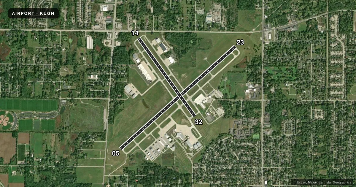
Runways & pattern
Full pagePattern entry · RWY 14
LEFT TRAFFIC| Runway | Heading (°M) | Length | Surface | Traffic |
|---|---|---|---|---|
| 05/23 | 45° / 225° | 6,001 ft | ASPH | 23 R |
| 14/32Favored | 141° / 321° | 3,750 ft | ASPH | Standard L |
Runway end performance
| End | TORA | TODA | ASDA | LDA | VGSI | Approach lights | Obstruction |
|---|---|---|---|---|---|---|---|
| 05 | — | — | — | — | VASI 4-box left(3°) | — | 12', road, 281' from thr, 502' R of cntrln, slope 6 |
| 23 | — | — | — | — | VASI 4-box left(3°) | MALSR | 1', road, 245' from thr, 500' R of cntrln, slope 45 |
| 14 | — | — | — | — | VASI 4-box left(3.5°) | — | 29', road, 205' from thr, 125' R of cntrln, slope 1 |
Declared distances in feet. TORA = takeoff run available, TODA = takeoff distance, ASDA = accelerate-stop, LDA = landing distance.
Airport sketch
Runways drawn to scale from FAA survey coordinates, rendered over satellite imagery. Not for navigation.
Approaches & charts
ILS · 1
Services on the field
Fuel grades, oxygen, maintenance, ramp storage and lighting — as declared to the FAA by the airport operator.
Fuel & services
- Fuel
- 100LLA
- Oxygen (bottled)
- HIGH/LOW
- Oxygen (bulk)
- HIGH/LOW
- Airframe repair
- Major
- Power plant repair
- Major
- Other services
- AFRT,AVNCS,CARGO,CHTR,INSTR,RNTL
Ramp & ground
- Transient storage
- Tie-down
- Hangar
- Customs
- Not available
- Lighting schedule
- SEE RMK
- Beacon schedule
- SS-SR
- Beacon
- White / Green (civil land)(WG)
- Wind indicator
- Lighted
- Segmented circle
- No
Fuel & FBOs
Cheapest 100LL and Jet A on the field and nearby. Always confirm with the FBO before taxi.
Airport notes
Surface conditions, obstructions, local procedures, lighting outages and other notes published with each FAA cycle.
General notes
- BIRDS ON & INVOF ARPT.
- FOR CD WHEN ATCT IS CLSD CTC CHICAGO APCH AT 847-289-0926.
Lighting notes
- ATCTVT MALSR RWY 23; REIL RWY 05; HIRL RWY 05/23; MIRL RWY 14/32 TWY LGTS - CTAF. WHEN ATCT CLSD TO INCR INTST & ACTVT - CTAF
Fuel notes
- 100LLFUEL IS PRVDD BY A DOD CONTRACT. 100 LL AVBL 24HR WITH CREDIT CARD FM SELF SERVE PUMP ON TSNT RAMP.
Approach & departure obstructions
- 14APCH RATIO IS 26:1 AT DSPLCD THLD.
Other notes
- FOR US CUSTOMS 2 HRS MIN ADVN NOTICE RQRD MON-FRI 11:00 - 19:00 LCL & BY 4PM FRI FOR WKEND ARRS. CTC CBP (224)529-1468.
- MANAGEREMAIL ADDRESS: SGOSS@WAUKEGANPORT.COM
VFR map & nearby airports
VFR sectional. Tap any ICAO chip to open that airport.
Key facts · KUGN
Answer card- ICAO
- KUGN
- Name
- WAUKEGAN NTL
- Location
- CHICAGO/WAUKEGAN, ILLINOIS
- Elevation
- 728.1 ft MSL
- Traffic pattern altitude
- 1,728.1 ft MSL (1,000 AGL)
- Control tower
- Towered · 0600-2000
- Total runways
- 2
- Longest runway
- 05/23 · 6,001 ft
- Published ILS approaches
- 1
- Published frequencies
- 7
- Magnetic variation
- 3°
- Current flight rules
- IFR
- Current wind
- 170° at 11 kt
- Favored runway now
- RWY 14
Waukegan NTL Airport sits in Chicago/Waukegan, Illinois. Field elevation is 728.1 ft MSL. The airport has 2 asphalt runways. The longest is runway 05/23 at 6,001 ft. The field is towered from 0600 to 2000. One ILS is published for runway 23. Pattern altitude is not published. Use 1,000 ft AGL for light piston traffic unless ATC or the current Chart Supplement says otherwise. That puts the standard pattern at 1,728.1 ft MSL.
Signature Aviation is on the field. It carries 100LL and Jet A. 100LL is also available 24 hours from the self-serve pump on the transient ramp. The tower controls the runway lighting on 23. It also controls the REIL on 05. High intensity lights are on 05 and 23. Medium intensity lights are on 14 and 32. Taxiway lights are controlled by CTAF. When the tower is closed, use CTAF to increase intensity and activate lighting.
First-time arrivals should pay attention to birds in and around the airport. Runway 14 also has a published displaced-threshold obstacle note, so review the current Chart Supplement before planning that end. Customs is available with advance notice only. Call ahead if you need it. For clearance delivery after tower hours, Chicago Approach handles it.