METAR & TAF KETB
Current METAR
Observed 14:55Z
KETB 271455Z AUTO 19009G14KT 10SM BKN012 OVC043 28/26 A2975 RMK AO2
- Wind
- 190° @ 9G14 kt
- Visibility
- 10 SM
- Temp / Dew
- 28°C / 26°C
- Altimeter
- 29.75 inHg
- Clouds
- OVC
- Density alt
- 2,872 ft
- Ceiling
- 1,200 ft AGL
- Rules
- MVFR
Airport info & contacts
Manager on record, flight service, ARTCC, attendance schedule and pattern altitude — published by the FAA and refreshed every 28 days.
Location
- From city
- 3 NM E
- VFR sectional
- CHICAGO
- ARTCC
- ZAU · CHICAGO
- NOTAM facility
- ETB (NOTAM-D)
Airport manager
- Name
- MIKE SHAW
- Phone
- 262-483-7432
- Address
- 1115 SOUTH MAIN, WEST BEND WI 53095
Flight service · Hours
- FSS GRB
- GREEN BAY1-800-WX-BRIEF
- Attendance
- MON-FRI · 0800-1800
- SAT-SUN · 0800-1700
Frequencies
Tap any row to copy the frequency to your clipboard.
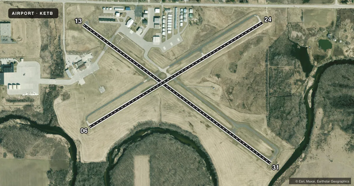
Runways & pattern
Full pagePattern entry · RWY 24
LEFT TRAFFIC| Runway | Heading (°M) | Length | Surface | Traffic |
|---|---|---|---|---|
| 13/31 | 125° / 305° | 4,494 ft | ASPH | Standard L |
| 06/24Favored | 58° / 238° | 3,898 ft | ASPH | Standard L |
Runway end performance
| End | TORA | TODA | ASDA | LDA | VGSI | Approach lights | Obstruction |
|---|---|---|---|---|---|---|---|
| 13 | — | — | — | — | PAPI 4-box left(3°) | — | 12', road, 370' from thr, 270' R of cntrln, slope 14 |
| 31 | — | — | — | — | PAPI 2-box left(3°) | — | 67', trees, 1356' from thr, 400' R of cntrln, slope 17 |
| 06 | — | — | — | — | — | — | 50', trees, 1044' from thr, 300' R of cntrln, slope 16 |
| 24 | — | — | — | — | — | — | 11', road, 200' from thr, 250' R of cntrln, slope 1 |
Declared distances in feet. TORA = takeoff run available, TODA = takeoff distance, ASDA = accelerate-stop, LDA = landing distance.
Airport sketch
Runways drawn to scale from FAA survey coordinates, rendered over satellite imagery. Not for navigation.
Approaches & charts
Services on the field
Fuel grades, oxygen, maintenance, ramp storage and lighting — as declared to the FAA by the airport operator.
Fuel & services
- Fuel
- 100LLA+
- Oxygen (bottled)
- Not available
- Oxygen (bulk)
- Not available
- Airframe repair
- Major
- Power plant repair
- Major
- Other services
- AFRT,CHTR,INSTR,RNTL,SALES
Ramp & ground
- Transient storage
- Tie-down
- Hangar
- Landing fee
- No fee published
- Customs
- Not available
- Lighting schedule
- SEE RMK
- Beacon schedule
- SS-SR
- Beacon
- White / Green (civil land)(WG)
- Wind indicator
- Lighted
- Segmented circle
- No
Fuel & FBOs
Cheapest 100LL and Jet A on the field and nearby. Always confirm with the FBO before taxi.
Airport notes
Surface conditions, obstructions, local procedures, lighting outages and other notes published with each FAA cycle.
General notes
- WHEN USING MIL HELIPAD MIL HELS USE PATTERNS TO THE NORTH OR WEST OF ARPT.
- COPTER TRNG IN PROGRESS 0630-2200 BLO 5000 FT.
- FUEL - J8 (NC-100LL, A).
- ARNG - OPR 1230-2200Z++ MON-TUE; 1230-0400Z++ WED-FRI. LTD PRK. PPR TRAN SVC DSN 724-7550, C262-334-6712.
- CAUTION - COPTER TRNG IN PROGRESS 1230-0400Z++ BLW 5000'. MIL COPTER USE PAT TO N OR W OF ARPT. DEER HAZ.
- ARNG - OPR 1230-2200Z++ MON-TUE; 1230-0400Z++ WED-FRI. LTD PRK. PPR TRAN SVC DSN 724-3417, C262-334-9154.
- CTC ARNG OPS 40.8/40.9/41.6/138.625/240.3/241.0.
- FOR CD CTC CHICAGO ARTCC AT 630-906-8921.
- WILDLIFE ON & INVOF ARPT.
Lighting notes
- ACTVT REIL RWY 13 & 31; PAPI RWY 13 & 31; MIRL RWY 06/24 - CTAF. MIRL RWY 13/31 PRESET TO LOW SS-SR, TO INCR INTST & ACTVT - CTAF.
Runway surface & condition
- H1MIL USE ONLY.
- H1BLUE LGTS.
Other notes
- MANAGERSHAWM@WESTBENDWI.GOV.
VFR map & nearby airports
VFR sectional. Tap any ICAO chip to open that airport.
Key facts · KETB
Answer card- ICAO
- KETB
- Name
- WEST BEND MUNI
- Location
- WEST BEND, WISCONSIN
- Elevation
- 887.9 ft MSL
- Traffic pattern altitude
- 1,887.9 ft MSL (1,000 AGL)
- Control tower
- Non-towered (use CTAF)
- Total runways
- 2
- Longest runway
- 13/31 · 4,494 ft
- Published ILS approaches
- 0
- Published frequencies
- 5
- Magnetic variation
- 1°
- Current flight rules
- MVFR
- Current wind
- 190° at 9 kt
- Favored runway now
- RWY 24
West Bend Muni sits in West Bend, Wisconsin. Field elevation is 887.9 ft MSL. The airport has two asphalt runways. The longest is 4,494 ft on runway 13/31. Runway 06/24 is 3,898 ft. There is no control tower, so expect self-announce traffic on CTAF 123.05. No ILS approaches are published here.
Pattern altitude is not published. Use 1,000 ft AGL for light piston operations unless the current Chart Supplement says otherwise. West Bend Air is the on-field FBO. It carries 100LL and Jet A. Prior permission is required for transient service. Parking is limited.
The field has a few operational items worth planning for. Helicopter training is reported below 5,000 ft. Military helicopters use patterns to the north or west of the airport. Deer hazard is published. Runway end identifier lights are active on runways 13 and 31. PAPI is installed on 13 and 31. Medium intensity lights are on 06/24. The 13 and 31 lights are preset low from sunset to sunrise. They can be increased by CTAF. For clearance delivery, contact Chicago Center. If you need current transient access or parking guidance, call the airport operator or the FBO directly before departure.