METAR & TAF KHXF
KHXF does not publish a METAR.
Showing the nearest reporting station: KETB (WEST BEND MUNI) · 12.2 NM away. Conditions at KHXF may differ.
METAR · KETB
Observed 03:55Z
KETB 270355Z AUTO 00000KT 10SM CLR 23/23 A2984 RMK AO2
- Wind
- 000° @ 0 kt
- Visibility
- 10 SM
- Temp / Dew
- 23°C / 23°C
- Altimeter
- 29.84 inHg
- Clouds
- CLR
- Density alt
- 2,386 ft
- Ceiling
- Unlimited
- Rules
- VFR
Airport info & contacts
Manager on record, flight service, ARTCC, attendance schedule and pattern altitude — published by the FAA and refreshed every 28 days.
Location
- From city
- 2 NM NW
- VFR sectional
- CHICAGO
- Pattern altitude
- 500 ft AGL · 1,570 ft MSL
- ARTCC
- ZAU · CHICAGO
- NOTAM facility
- GRB (NOTAM-D)
Airport manager
- Name
- TIM PUESTOW
- Phone
- 262-673-8225
- Address
- 109 N MAIN, HARTFORD WI 53027
Flight service · Hours
- FSS GRB
- GREEN BAY1-800-WX-BRIEF
- Attendance
- Unattended
Frequencies
Tap any row to copy the frequency to your clipboard.
Runways & pattern
Full pagePattern entry · RWY 09
LEFT TRAFFIC| Runway | Heading (°M) | Length | Surface | Traffic |
|---|---|---|---|---|
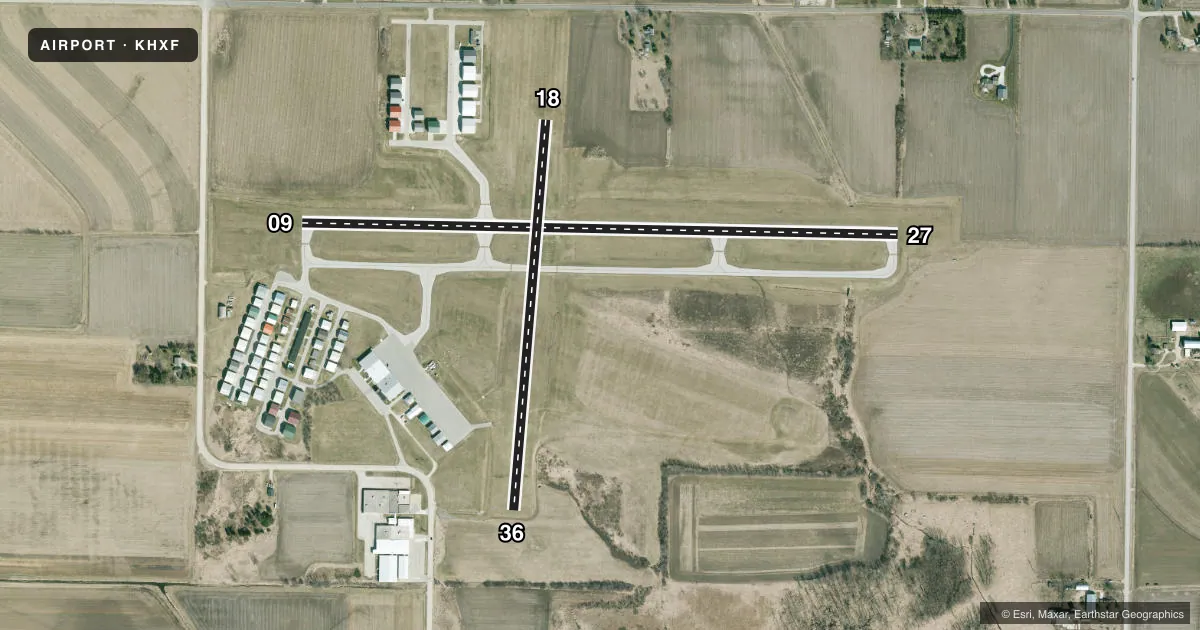
| 09/27 | 88° / 268° | 3,401 ft | ASPH | Standard L |
| 18/36 | 182° / 2° | 2,231 ft | TURF | Standard L |
Runway end performance
| End | TORA | TODA | ASDA | LDA | VGSI | Approach lights | Obstruction |
|---|---|---|---|---|---|---|---|
| 09 | — | — | — | — | PAPI 4-box left(3°) | — | — |
| 27 | — | — | — | — | PAPI 4-box left(3°) | — | — |
Declared distances in feet. TORA = takeoff run available, TODA = takeoff distance, ASDA = accelerate-stop, LDA = landing distance.
Airport sketch
Runways drawn to scale from FAA survey coordinates, rendered over satellite imagery. Not for navigation.
Approaches & charts
Services on the field
Fuel grades, oxygen, maintenance, ramp storage and lighting — as declared to the FAA by the airport operator.
Fuel & services
- Fuel
- 100LLA+MOGAS
- Oxygen (bottled)
- Not available
- Oxygen (bulk)
- Not available
- Airframe repair
- Not available
- Power plant repair
- Not available
- Other services
- GLD,INSTR,RNTL,TOW
Ramp & ground
- Transient storage
- Tie-down
- Hangar
- Landing fee
- No fee published
- Customs
- Not available
- Lighting schedule
- SEE RMK
- Beacon schedule
- SS-SR
- Beacon
- White / Green (civil land)(WG)
- Wind indicator
- Lighted
- Segmented circle
- Yes
Fuel & FBOs
Cheapest 100LL and Jet A on the field and nearby. Always confirm with the FBO before taxi.
Airport notes
Surface conditions, obstructions, local procedures, lighting outages and other notes published with each FAA cycle.
General notes
- GLIDER & ULTRALIGHT ACTVTY ON ARPT.
- (A23) RIGHT TFC PAT ULTRALIGHT & GLIDER ACFT.
- FOR CD CTC CHICAGO ARTCC AT 630-906-8921.
Lighting notes
- ACTVT REIL RWY 9 & 27 - CTAF. MIRL RWY 09/27 PRESET TO LOW SS-SR, TO INCR INTST & ACTVT - CTAF.
Fuel notes
- 100LL24 HR FUEL AVBL WITH CREDIT CARD.
Approach & departure obstructions
- 18SLIGHT DOWNHILL SLOPE.
- 36+78 FT WATER TWR 3885 FT FM APCH END.
- 18MKD WITH ORANGE & WHITE WOODEN A-FRAMES.
- 36MKD WITH ORANGE & WHITE WOODEN A-FRAMES.
Other notes
- TPA: 500 FT AGL ULTRALIGHTS.
- MANAGERTPUESTOW@HARTFORD.WI.GOV.
VFR map & nearby airports
VFR sectional. Tap any ICAO chip to open that airport.
Key facts · KHXF
Answer card- ICAO
- KHXF
- Name
- HARTFORD MUNI
- Location
- HARTFORD, WISCONSIN
- Elevation
- 1,070 ft MSL
- Traffic pattern altitude
- 1,570 ft MSL (500 AGL)
- Control tower
- Non-towered (use CTAF)
- Total runways
- 2
- Longest runway
- 09/27 · 3,401 ft
- Published ILS approaches
- 0
- Published frequencies
- 4
- Magnetic variation
- 3°
- Current flight rules
- VFR
- Current wind
- 000° at 0 kt
- Favored runway now
- –
Hartford Muni sits in Hartford, Wisconsin. Field elevation is 1,070 ft MSL. The airport has two runways. The longest is 09/27 at 3,401 ft. There is no control tower. No ILS approaches are published. Pattern altitude is 500 ft AGL, which is 1,570 ft MSL.
The on-field FBO is Hartford Municipal Airport. It carries 100LL, Jet A and MOGAS. Twenty-four hour fuel is available with credit card. The airport also has glider and ultralight activity. Right traffic is used for ultralight and glider aircraft. That matters if you are arriving VFR. The field can have mixed traffic. Runway 09/27 has REIL lighting. The medium intensity runway lights on 09/27 are preset low from sunset to sunrise. They can be increased via CTAF.
Runway 18 has a slight downhill slope. Runway 18 and Runway 36 are marked with orange and white wooden A-frames. There is also a 78 ft water tower 3,885 ft from the approach end of Runway 36. For clearance delivery, contact Chicago ARTCC. First-time pilots should review the current Chart Supplement before arrival. Check the pattern and lighting notes closely. That matters if you are flying at night or mixing with glider traffic.