METAR & TAF 0C0
0C0 does not publish a METAR.
Showing the nearest reporting station: KJVL (SOUTHERN WISCONSIN RGNL) · 22.3 NM away. Conditions at 0C0 may differ.
METAR · KJVL
Observed 17:45Z
KJVL 291745Z 07007KT 10SM CLR 27/14 A3005
- Wind
- 070° @ 7 kt
- Visibility
- 10 SM
- Temp / Dew
- 27°C / 14°C
- Altimeter
- 30.05 inHg
- Clouds
- CLR
- Density alt
- 2,411 ft
- Ceiling
- Unlimited
- Rules
- VFR
Airport info & contacts
Manager on record, flight service, ARTCC, attendance schedule and pattern altitude — published by the FAA and refreshed every 28 days.
Location
- From city
- 1 NM SW
- VFR sectional
- CHICAGO
- Pattern altitude
- 600 ft AGL · 1,513 ft MSL
- ARTCC
- ZAU · CHICAGO
- NOTAM facility
- IKK (NOTAM-D)
Airport manager
- Name
- DAVE DACY
- Phone
- 815-943-9876
- Address
- 22211 AIRPORT RD, PO BOX 225, HARVARD IL 60033
Flight service · Hours
- FSS IKK
- KANKAKEE1-800-WX-BRIEF
- Attendance
- 0800-1700
Frequencies
Tap any row to copy the frequency to your clipboard.
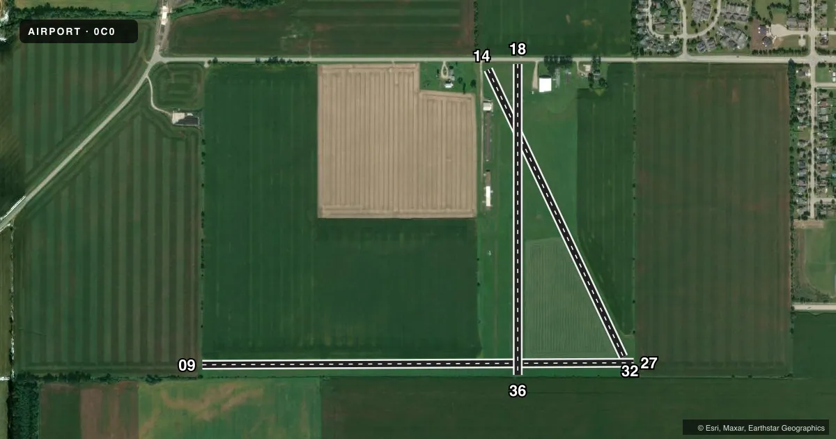
Runways & pattern
Full pagePattern entry · RWY 09
LEFT TRAFFIC| Runway | Heading (°M) | Length | Surface | Traffic |
|---|---|---|---|---|
| 09/27Favored | 90° / 270° | 3,589 ft | TURF | Standard L |
| 14/32 | 155° / 335° | 2,633 ft | TURF | Standard L |
| 18/36 | 180° / 0° | 2,577 ft | TURF | Standard L |
Runway end performance
| End | TORA | TODA | ASDA | LDA | VGSI | Approach lights | Obstruction |
|---|---|---|---|---|---|---|---|
| 09 | — | — | — | — | — | — | 44', tree, 405' from thr, 117' R of cntrln, slope 9 |
| 27 | — | — | — | — | — | — | tree, slope 20 |
| 14 | — | — | — | — | — | — | 42', tree, 542' from thr, 25' R of cntrln, slope 13 |
| 18 | — | — | — | — | — | — | 15', road, 30' from thr, 0' R of cntrln, slope 2 |
Declared distances in feet. TORA = takeoff run available, TODA = takeoff distance, ASDA = accelerate-stop, LDA = landing distance.
Airport sketch
Runways drawn to scale from FAA survey coordinates, rendered over satellite imagery. Not for navigation.
Approaches & charts
Services on the field
Fuel grades, oxygen, maintenance, ramp storage and lighting — as declared to the FAA by the airport operator.
Fuel & services
- Fuel
- 100LL
- Oxygen (bottled)
- Not available
- Oxygen (bulk)
- Not available
- Airframe repair
- Major
- Power plant repair
- Major
- Other services
- INSTR,RNTL,SALES
Ramp & ground
- Transient storage
- Tie-down
- Hangar
- Landing fee
- No fee published
- Customs
- Not available
- Lighting schedule
- SS-SR
- Wind indicator
- Lighted
- Segmented circle
- No
Fuel & FBOs
Cheapest 100LL and Jet A on the field and nearby. Always confirm with the FBO before taxi.
Airport notes
Surface conditions, obstructions, local procedures, lighting outages and other notes published with each FAA cycle.
General notes
- FOR CD CTC CHICAGO ARTCC AT 630-906-8921.
Runway surface & condition
- 18/36RWY 18/36 NSTD LIRL; NSTD SPACING & NON-FRANGIBLE. RY 18/36 2,272' LIGHTED.
Approach & departure obstructions
- 09DSPLCD THLD MKD WITH WHITE TIRES.
- 14DSPLCD THLD MKD WITH WHITE TIRES.
- 18RY 18 DSPLCD THLD MKD WITH WHITE TIRES AND ORANGE & WHITE BARRELS.
- 09APCH RATIO 23:1 TO DSPLCD THLD.
- 14SLOPE 24:1 TO DSPLCD THLD.
- 18APCH RATIO 22:1 TO DSPLCD THLD.
- 09SEASONAL CROPS AT RWY 09, RWY 27, RWY 36, RWY 32 ENDS
Other notes
- THIS AIRPORT HAS BEEN SURVEYED BY THE NATIONAL GEODETIC SURVEY.
- EXISTED PRIOR TO 1959.
VFR map & nearby airports
VFR sectional. Tap any ICAO chip to open that airport.
Key facts · 0C0
Answer card- ICAO
- 0C0
- Name
- DACY
- Location
- HARVARD, ILLINOIS
- Elevation
- 913.2 ft MSL
- Traffic pattern altitude
- 1,513.2 ft MSL (600 AGL)
- Control tower
- Non-towered (use CTAF)
- Total runways
- 3
- Longest runway
- 09/27 · 3,589 ft
- Published ILS approaches
- 0
- Published frequencies
- 1
- Magnetic variation
- 0°
- Current flight rules
- VFR
- Current wind
- 070° at 7 kt
- Favored runway now
- RWY 09
Dacy Airport sits in Harvard, Illinois. Field elevation is 913.2 ft MSL. It has 3 turf runways. The longest is runway 09/27 at 3,589 ft. There is no control tower. CTAF is 122.9. No ILS approaches are published here.
Pattern altitude is 600 ft AGL, which is 1,513.2 ft MSL. That matters here because all three runways are turf. Runway 18/36 is lighted for 2,272 ft. The published remarks also call out displaced thresholds on several runways. Runway 18 has white tires and orange and white barrels marking the displaced threshold. Runway 09 and runway 14 also have displaced thresholds marked with white tires. Seasonal crops are present near the ends of runways 09, 27, 36 and 32. The airport has been surveyed by the National Geodetic Survey.
Dacy Airshows is on the field. It carries 100LL. For clearance delivery, the remarks direct pilots to Chicago ARTCC at 630-906-8921. If you are planning a first stop here, treat the turf, the displaced thresholds and the seasonal crop hazards as the main items to brief before arrival.