METAR & TAF KMRJ
Current METAR
Observed 06:15Z
KMRJ 170615Z AUTO RMK AO2 PWINO
- Wind
- Calm
- Visibility
- —
- Temp / Dew
- —
- Altimeter
- —
- Clouds
- Clear
- Density alt
- —
- Ceiling
- Unlimited
- Rules
- VFR
Airport info & contacts
Manager on record, flight service, ARTCC, attendance schedule and pattern altitude — published by the FAA and refreshed every 28 days.
Location
- From city
- 3 NM NW
- VFR sectional
- CHICAGO
- ARTCC
- ZAU · CHICAGO
- NOTAM facility
- MRJ (NOTAM-D)
Airport manager
- Name
- CODY WILLIAMS
- Phone
- 608-553-7571
- Address
- 3151 STATE RD 39, MINERAL POINT WI 53565
Flight service · Hours
- FSS GRB
- GREEN BAY1-800-WX-BRIEF
- Attendance
- MON-FRI · 0600-1600
- SAT-SUN · ON CALL
Frequencies
Tap any row to copy the frequency to your clipboard.
Runways & pattern
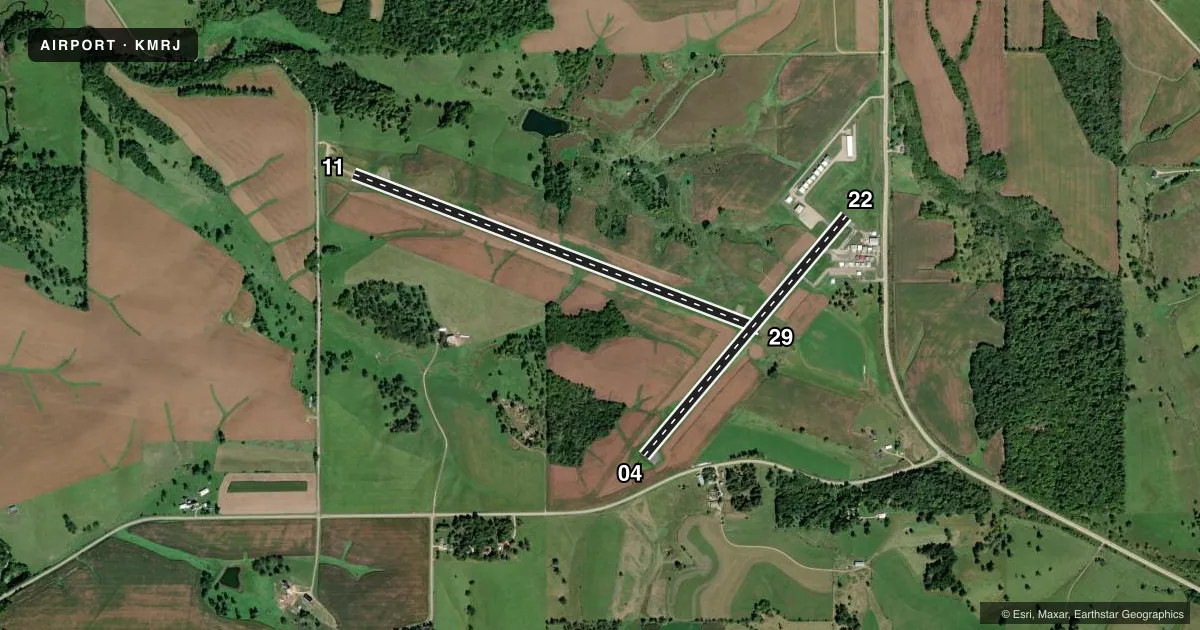
Full pagePattern entry · RWY 11
LEFT TRAFFIC| Runway | Heading (°M) | Length | Surface | Traffic |
|---|---|---|---|---|
| 11/29 | 111° / 291° | 5,001 ft | ASPH | Standard L |
| 04/22 | 40° / 220° | 3,600 ft | ASPH | Standard L |
Runway end performance
| End | TORA | TODA | ASDA | LDA | VGSI | Approach lights | Obstruction |
|---|---|---|---|---|---|---|---|
| 11 | — | — | — | — | PAPI 2-box left(3°) | — | — |
| 29 | — | — | — | — | PAPI 2-box left(3°) | — | — |
| 04 | — | — | — | — | PAPI 2-box left(3°) | — | — |
| 22 | — | — | — | — | PAPI 2-box left(3°) | — | — |
Declared distances in feet. TORA = takeoff run available, TODA = takeoff distance, ASDA = accelerate-stop, LDA = landing distance.
Airport sketch
Runways drawn to scale from FAA survey coordinates, rendered over satellite imagery. Not for navigation.
Approaches & charts
Services on the field
Fuel grades, oxygen, maintenance, ramp storage and lighting — as declared to the FAA by the airport operator.
Fuel & services
- Fuel
- 100LLA+
- Oxygen (bottled)
- Low pressure
- Oxygen (bulk)
- Not available
- Airframe repair
- Major
- Power plant repair
- Major
- Other services
- INSTR
Ramp & ground
- Transient storage
- Tie-down
- Hangar
- Landing fee
- No fee published
- Customs
- Not available
- Lighting schedule
- SEE RMK
- Beacon schedule
- SS-SR
- Beacon
- White / Green (civil land)(WG)
- Wind indicator
- Yes
- Segmented circle
- No
Fuel & FBOs
Cheapest 100LL and Jet A on the field and nearby. Always confirm with the FBO before taxi.
Airport notes
Surface conditions, obstructions, local procedures, lighting outages and other notes published with each FAA cycle.
General notes
- BIRDS ON & INVOF ARPT.
- FOR NOISE ABATEMENT PREFERED NO WIND RY IS RY 29.
- FOR CD CTC CHICAGO ARTCC AT 630-906-8921.
Lighting notes
- MIRL RWY 11/29 PRESET TO LOW SS-SR; TO INCR INTST AND ACTVT PAPI RWY 04, 11, 22 & 29; MIRL RWY 04/22 - CTAF.
Fuel notes
- 100LLFUEL AVBL 24 HR SELF SVC.
VFR map & nearby airports
VFR sectional. Tap any ICAO chip to open that airport.
Key facts · KMRJ
Answer card- ICAO
- KMRJ
- Name
- IOWA COUNTY
- Location
- MINERAL POINT, WISCONSIN
- Elevation
- 1,170.7 ft MSL
- Traffic pattern altitude
- 2,170.7 ft MSL (1,000 AGL)
- Control tower
- Non-towered (use CTAF)
- Total runways
- 2
- Longest runway
- 11/29 · 5,001 ft
- Published ILS approaches
- 0
- Published frequencies
- 2
- Magnetic variation
- 0°
- Current flight rules
- VFR
- Current wind
- Calm / unavailable
- Favored runway now
- –
Iowa County Airport is in Mineral Point, Wisconsin. The field elevation is 1,170.7 ft MSL. It has two asphalt runways. The longest is runway 11/29 at 5,001 ft. There is no control tower. CTAF and UNICOM are both 122.8.
No ILS approaches are published here. Pattern altitude is not published, so use the standard 1,000 ft AGL for light piston traffic unless the current Chart Supplement says otherwise. The on-field FBO is Iowa County Airport. It carries 100LL and Jet A Prist. Fuel is also available 24 hours via self-serve 100LL.
A few operational notes matter here. Medium intensity runway lights on 11/29 come up preset to low from sunset to sunrise. Use the CTAF to increase intensity and to activate the precision approach path indicators on runways 04, 11, 22 and 29. For noise abatement, the preferred no-wind runway is 29. Birds are reported on and near the airport, so keep an eye out on arrival and departure. Clearance delivery is handled through Chicago ARTCC at 630-906-8921. With no tower and no published ILS, a current chart review is smart before you go in.