METAR & TAF C29
Current METAR
Observed 14:55Z
KC29 271455Z AUTO 21012KT 10SM 30/24 A2973 RMK AO1 T03040242
- Wind
- 210° @ 12 kt
- Visibility
- 10 SM
- Temp / Dew
- 30°C / 24°C
- Altimeter
- 29.73 inHg
- Clouds
- Clear
- Density alt
- 3,186 ft
- Ceiling
- Unlimited
- Rules
- VFR
Airport info & contacts
Manager on record, flight service, ARTCC, attendance schedule and pattern altitude — published by the FAA and refreshed every 28 days.
Location
- From city
- 5 NM NW
- VFR sectional
- CHICAGO
- ARTCC
- ZAU · CHICAGO
- NOTAM facility
- GRB (NOTAM-D)
Airport manager
- Name
- RICHARD MOREY
- Phone
- 608-836-1711
- Address
- 8300 AIRPORT ROAD, 7426 HUBBARD AVE, MIDDLETON WI 53562
Flight service · Hours
- FSS GRB
- GREEN BAY1-800-WX-BRIEF
- Attendance
- 0800-1730
Frequencies
Tap any row to copy the frequency to your clipboard.
Runways & pattern
Full pagePattern entry · RWY 19
LEFT TRAFFIC| Runway | Heading (°M) | Length | Surface | Traffic |
|---|---|---|---|---|
| 10/28 | 99° / 279° | 4,001 ft | ASPH | Standard L |
| 01/19Favored | 6° / 186° | 1,050 ft | TURF | Standard L |
Runway end performance
| End | TORA | TODA | ASDA | LDA | VGSI | Approach lights | Obstruction |
|---|---|---|---|---|---|---|---|
| 10 | — | — | — | — | PAPI 2-box left(4°) | — | 104', trees, 2190' from thr, 435' R of cntrln, slope 19 |
| 28 | — | — | — | — | PAPI 2-box left(4°) | — | 53', tree, 1920' from thr, 345' R of cntrln, slope 32 |
Declared distances in feet. TORA = takeoff run available, TODA = takeoff distance, ASDA = accelerate-stop, LDA = landing distance.
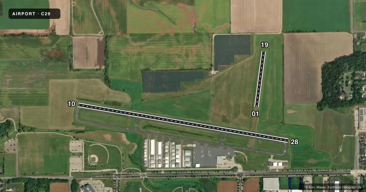
Airport sketch
Runways drawn to scale from FAA survey coordinates, rendered over satellite imagery. Not for navigation.
Approaches & charts
ILS · 1
Services on the field
Fuel grades, oxygen, maintenance, ramp storage and lighting — as declared to the FAA by the airport operator.
Fuel & services
- Fuel
- 100LLA+UL94
- Oxygen (bottled)
- Not available
- Oxygen (bulk)
- HIGH/LOW
- Airframe repair
- Major
- Power plant repair
- Major
- Other services
- CHTR,INSTR,RNTL
Ramp & ground
- Transient storage
- Tie-down
- Hangar
- Landing fee
- No fee published
- Customs
- Not available
- Lighting schedule
- SEE RMK
- Beacon schedule
- SS-SR
- Beacon
- White / Green (civil land)(WG)
- Wind indicator
- Lighted
- Segmented circle
- No
Fuel & FBOs
Cheapest 100LL and Jet A on the field and nearby. Always confirm with the FBO before taxi.
Airport notes
Surface conditions, obstructions, local procedures, lighting outages and other notes published with each FAA cycle.
General notes
- BIRDS ON & INVOF ARPT.
- AVOID NOISE SENSITIVE AREA 1 MI SW; SEE CITY OR MOREY CO WEBSITES FOR DETAILS.
- FOR CD CTC MADISON APP/DEP CON AT 608-249-8240. WHEN MADISON APCH CLSD, FOR CD CTC CHICAGO ARTCC AT 630-906-8921.
- RWY 01/19 CLSD FM NOV 01 THRU APR 30.
Lighting notes
- MIRL RWY 10/28 PRESET TO LOW SS-SR; TO INCR INTST & ACTVT REIL RWY 10 & 28; MIRL RWY 10/28 - CTAF. PAPI RWY 10 & 28 OPR CONSLY.
Other notes
- EXISTED PRIOR TO 1959.
VFR map & nearby airports
VFR sectional. Tap any ICAO chip to open that airport.
Key facts · C29
Answer card- ICAO
- C29
- Name
- MIDDLETON MUNI/MOREY FLD
- Location
- MIDDLETON, WISCONSIN
- Elevation
- 928 ft MSL
- Traffic pattern altitude
- 1,928 ft MSL (1,000 AGL)
- Control tower
- Non-towered (use CTAF)
- Total runways
- 2
- Longest runway
- 10/28 · 4,001 ft
- Published ILS approaches
- 1
- Published frequencies
- 4
- Magnetic variation
- 1°
- Current flight rules
- VFR
- Current wind
- 210° at 12 kt
- Favored runway now
- RWY 19
Middleton Muni/Morey Fld is in Middleton, Wisconsin. The field elevation is 928 ft MSL. It has two runways. The longest is 10/28 at 4,001 ft asphalt. Runway 01/19 is 1,050 ft turf. Runway 01/19 is closed from November 1 through April 30. Plan on 10/28 for most arrivals and departures in the colder months.
There is no control tower. CTAF and UNICOM are both 123.0. Madison Approach and Departure Control handles clearance delivery at 608-249-8240. When Madison Approach is closed, clearance delivery goes through Chicago ARTCC at 630-906-8921. The airport has one ILS approach for runway 10. Pattern altitude is not published. Use 1,000 ft AGL for light piston operations unless the current Chart Supplement says otherwise. That puts the pattern at 1,928 ft MSL.
Morey Airplane Co. is on the field. It carries AVGAS 100LL, JET A PRIST and UL94. Runway 10/28 has medium intensity lights that come up in a low preset from sunset to sunrise. Use CTAF to increase intensity and to activate the runway end identifier lights on 10 and 28. Watch for birds in the area. Avoid the noise sensitive area one mile southwest. Runway 01 and Runway 19 are marked with yellow cones. This field also has a long history. It existed before 1959.