METAR & TAF 91C
91C does not publish a METAR.
Showing the nearest reporting station: KDLL (BARABOO/WISCONSIN DELLS RGNL) · 13.5 NM away. Conditions at 91C may differ.
METAR · KDLL
Observed 06:15Z
KDLL 270615Z AUTO 00000KT 7SM CLR 24/24 A2982 RMK AO2 T02390236
- Wind
- 000° @ 0 kt
- Visibility
- 7 SM
- Temp / Dew
- 24°C / 24°C
- Altimeter
- 29.82 inHg
- Clouds
- CLR
- Density alt
- 2,236 ft
- Ceiling
- Unlimited
- Rules
- VFR
Airport info & contacts
Manager on record, flight service, ARTCC, attendance schedule and pattern altitude — published by the FAA and refreshed every 28 days.
Location
- From city
- 2 NM W
- VFR sectional
- CHICAGO
- ARTCC
- ZAU · CHICAGO
- NOTAM facility
- GRB (NOTAM-D)
Airport manager
- Name
- SAUK PRAIRIE AIRPORT INC.
- Phone
- 608-577-3754
- Address
- P O BOX 7, PRAIRIE DU SAC WI 53754
Flight service · Hours
- FSS GRB
- GREEN BAY1-800-WX-BRIEF
- Attendance
- Unattended
Frequencies
Tap any row to copy the frequency to your clipboard.
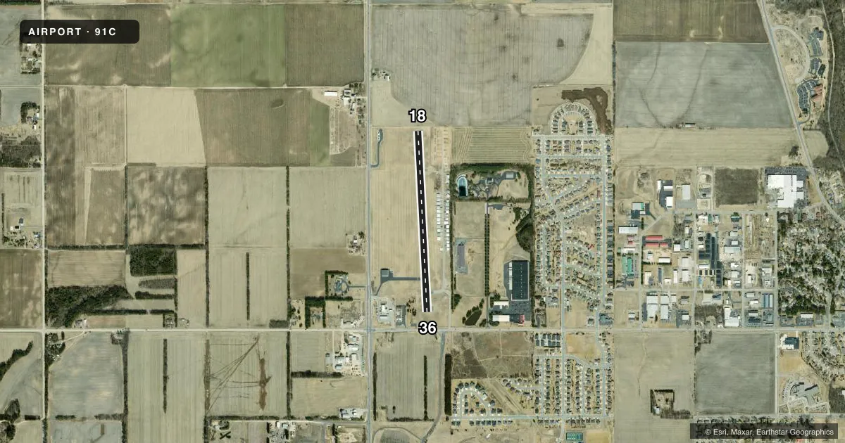
Runways & pattern
Full pagePattern entry · RWY 18
LEFT TRAFFICRunway end performance
| End | TORA | TODA | ASDA | LDA | VGSI | Approach lights | Obstruction |
|---|---|---|---|---|---|---|---|
| 18 | — | — | — | — | PAPI 2-box left(3°) | — | — |
| 36 | — | — | — | — | PAPI 2-box left(3°) | — | — |
Declared distances in feet. TORA = takeoff run available, TODA = takeoff distance, ASDA = accelerate-stop, LDA = landing distance.
Airport sketch
Runways drawn to scale from FAA survey coordinates, rendered over satellite imagery. Not for navigation.
Approaches & charts
Services on the field
Fuel grades, oxygen, maintenance, ramp storage and lighting — as declared to the FAA by the airport operator.
Fuel & services
- Fuel
- 100LLUL94
- Oxygen (bottled)
- Not available
- Oxygen (bulk)
- Not available
- Airframe repair
- Not available
- Power plant repair
- Not available
- Other services
- INSTR,SALES
Ramp & ground
- Transient storage
- Tie-down
- Landing fee
- No fee published
- Customs
- Not available
- Lighting schedule
- SEE RMK
- Beacon schedule
- SS-SR
- Beacon
- White / Green (civil land)(WG)
- Wind indicator
- Lighted
- Segmented circle
- No
Fuel & FBOs
Cheapest 100LL and Jet A on the field and nearby. Always confirm with the FBO before taxi.
Airport notes
Surface conditions, obstructions, local procedures, lighting outages and other notes published with each FAA cycle.
General notes
- ULTRALGT & HEL ACT ON & INVOF ARPT.
- MAINT VEHICLE TFC ON AND INVOF ARPT.
- W RAMP AND TWY PVT, CLSD TSNT.
- AVOID HOSPITAL/HELIPAD 3,000 FT SOUTHEAST OF RY 36 THLD.
- RY 18 DEPS CLIMB TO 1,800 FT MSL ON RY HEADING BFR TURNING EAST/SOUTHEAST.
- TKOFS & LDGS ARE PROHIBITED ON UNPAVED SFCS.
- FOR CD CTC MADISON APP/DEP CON AT 608-249-8240. WHEN MADISON APCH CLSD, FOR CD CTC CHICAGO ARTCC AT 630-906-8921.
Lighting notes
- ACTVT MIRL RY 18/36, REIL RYS 18 & 36, & PAPI RYS 18 & 36 - CTAF.
Fuel notes
- 100LL24 HR SELF SVC FUEL AVBL WITH CREDIT CARD.
Approach & departure obstructions
- 3625 FT TREES AT RWY END, 225L.
VFR map & nearby airports
VFR sectional. Tap any ICAO chip to open that airport.
Key facts · 91C
Answer card- ICAO
- 91C
- Name
- SAUK/PRAIRIE
- Location
- PRAIRIE DU SAC, WISCONSIN
- Elevation
- 832 ft MSL
- Traffic pattern altitude
- 1,832 ft MSL (1,000 AGL)
- Control tower
- Non-towered (use CTAF)
- Total runways
- 1
- Longest runway
- 18/36 · 2,936 ft
- Published ILS approaches
- 0
- Published frequencies
- 3
- Magnetic variation
- 0°
- Current flight rules
- VFR
- Current wind
- 000° at 0 kt
- Favored runway now
- –
SAUK/PRAIRIE (91C) sits in Prairie du Sac, Wisconsin. The field elevation is 832 ft MSL. It has one runway, 18/36, which is 2,936 ft long and asphalt. There is no control tower. Pattern altitude is not published, so light piston traffic should use the standard 1,000 ft AGL unless the current Chart Supplement says otherwise. No ILS approaches are published here.
Blue Sky Flight is on the field. It carries 100LL and UL94. Twenty-four hour self-serve fuel is available with credit card. That helps for after-hours arrivals. Still verify current access with the FBO directly before you go.
This is a non-towered field with Madison Approach/Departure handling clearances when needed. When Madison Approach is closed, clearance delivery goes through Chicago ARTCC. Keep an eye out for maintenance vehicles and ultralight activity in the area. West ramp and taxiway are private and closed to transient aircraft. There is also a hospital and helipad about 3,000 ft southeast of the runway 36 threshold, so plan your pattern and departure path with that in mind. Runway 18 departures should climb to 1,800 ft MSL on runway heading before turning east or southeast. Runway lighting, REILs and PAPI are all controlled by CTAF.