METAR & TAF C35
Current METAR
Observed 13:35Z
KC35 261335Z AUTO 18004KT 10SM CLR 26/25 A2990 RMK AO2 T02600250 PWINO
- Wind
- 180° @ 4 kt
- Visibility
- 10 SM
- Temp / Dew
- 26°C / 25°C
- Altimeter
- 29.90 inHg
- Clouds
- CLR
- Density alt
- 2,468 ft
- Ceiling
- Unlimited
- Rules
- VFR
Airport info & contacts
Manager on record, flight service, ARTCC, attendance schedule and pattern altitude — published by the FAA and refreshed every 28 days.
Location
- From city
- 1 NM E
- VFR sectional
- CHICAGO
- ARTCC
- ZAU · CHICAGO
- NOTAM facility
- GRB (NOTAM-D)
Airport manager
- Name
- TOM PARKER
- Phone
- 608-524-2322
- Address
- 1720 E MAIN, REEDSBURG WI 53959
Flight service · Hours
- FSS GRB
- GREEN BAY1-800-WX-BRIEF
- Attendance
- 0800-1600
Frequencies
Tap any row to copy the frequency to your clipboard.
Runways & pattern
Full pagePattern entry · RWY 18
LEFT TRAFFIC| Runway | Heading (°M) | Length | Surface | Traffic |
|---|---|---|---|---|
| 18/36Favored | 181° / 1° | 4,840 ft | ASPH | Standard L |
| 07/25 | 69° / 249° | 2,510 ft | ASPH | Standard L |
Runway end performance
| End | TORA | TODA | ASDA | LDA | VGSI | Approach lights | Obstruction |
|---|---|---|---|---|---|---|---|
| 18 | 4,540' | 4,540' | 4,540' | 4,100' | PAPI 2-box left(3°) | — | 21', road, 230' from thr, 0' R of cntrln, slope 1 |
| 36 | 4,400' | 4,400' | 4,400' | 4,100' | — | — | 17', rr, 200' from thr, 180' R of cntrln, slope 0 |
| 07 | 2,210' | 2,210' | 2,210' | 1,980' | — | — | 49', trees, 945' from thr, 225' R of cntrln, slope 15 |
| 25 | 2,280' | 2,280' | 2,280' | 1,980' | — | — | 12', road, 200' from thr, 0' R of cntrln, slope 0 |
Declared distances in feet. TORA = takeoff run available, TODA = takeoff distance, ASDA = accelerate-stop, LDA = landing distance.
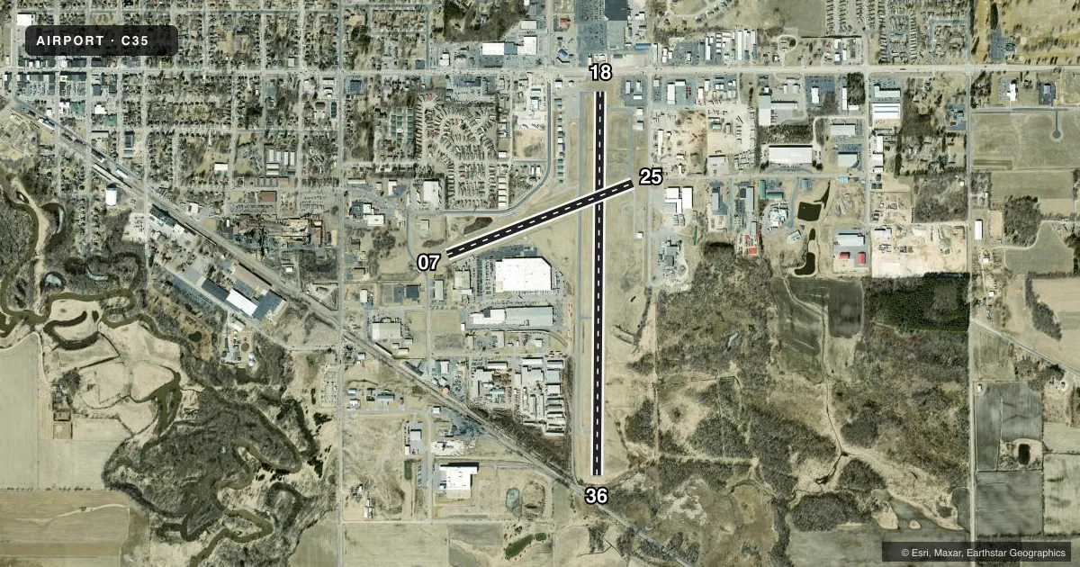
Airport sketch
Runways drawn to scale from FAA survey coordinates, rendered over satellite imagery. Not for navigation.
Approaches & charts
Services on the field
Fuel grades, oxygen, maintenance, ramp storage and lighting — as declared to the FAA by the airport operator.
Fuel & services
- Fuel
- 100LLA+
- Oxygen (bottled)
- Not available
- Oxygen (bulk)
- Not available
- Airframe repair
- Major
- Power plant repair
- Major
- Other services
- INSTR,RNTL
Ramp & ground
- Transient storage
- Tie-down
- Hangar
- Landing fee
- No fee published
- Customs
- Not available
- Lighting schedule
- SEE RMK
- Beacon schedule
- SS-SR
- Beacon
- White / Green (civil land)(WG)
- Wind indicator
- Lighted
- Segmented circle
- Yes
Fuel & FBOs
Cheapest 100LL and Jet A on the field and nearby. Always confirm with the FBO before taxi.
Airport notes
Surface conditions, obstructions, local procedures, lighting outages and other notes published with each FAA cycle.
General notes
- FOR CD CTC MADISON APP/DEP CON AT 608-249-8240. WHEN MADISON APCH CLSD, FOR CD CTC CHICAGO ARTCC AT 630-906-8921.
Lighting notes
- MIRL RWY 18/36 & 07/25 PRESET TO LOW SS-SR; TO INCR INTST AND ACTVT REIL RWY 18 & 36; PAPI RWY 18 - CTAF.
Fuel notes
- 100LL24 HR FUEL AVBL WITH CREDIT CARD.
Approach & departure obstructions
- 3617 FT RR 75 FT FM RWY END 250 FT L.
- 07DITCH 10 FT FM RWY END 60 FT L.
- 1810 FT FENCE 190 FT FM RWY END, 120 FT R.
- 2510 FT FENCE 175 FT FM RWY END, 40 FT L.
- 07APCH RATIO 20:1 TO DSPLCD THR.
- 18APCH SLP 20:1 TO DTHR.
- 25APCH RATIO 20:1 TO DSPLCD THR.
- 36APCH SLP 20:1 TO DTHR.
Other notes
- MANAGEREMAIL ADDRESS: REEDSBURGAVIATION@GMAIL.COM (ALL LOWER CASE)
VFR map & nearby airports
VFR sectional. Tap any ICAO chip to open that airport.
Key facts · C35
Answer card- ICAO
- C35
- Name
- REEDSBURG MUNI
- Location
- REEDSBURG, WISCONSIN
- Elevation
- 906.2 ft MSL
- Traffic pattern altitude
- 1,906.2 ft MSL (1,000 AGL)
- Control tower
- Non-towered (use CTAF)
- Total runways
- 2
- Longest runway
- 18/36 · 4,840 ft
- Published ILS approaches
- 0
- Published frequencies
- 4
- Magnetic variation
- 0°
- Current flight rules
- VFR
- Current wind
- 180° at 4 kt
- Favored runway now
- RWY 18
Reedsburg Muni sits in Reedsburg, Wisconsin. The field elevation is 906.2 ft MSL. It has two asphalt runways. The longest is 18/36 at 4,840 ft. This is a non-towered field, so plan to work the CTAF and keep your scan tight in the pattern.
No ILS approaches are published here. Pattern altitude is not published in the facts, so use the standard 1,000 ft AGL for light piston traffic unless the current Chart Supplement says otherwise. The on-field FBO is Reedsburg Municipal Airport. It carries 100LL and Jet A Prist. Twenty-four-hour fuel is available with a credit card.
A few published remarks matter for planning. Runway lighting is preset to low from sunset to sunrise. Use the PAPI on runway 18 to increase intensity. It also activates the runway end identifier lights for 18 and 36. There are displaced-threshold and approach-slope notes on all four runway ends. There is a ditch near runway 07. There is a fence near runway 18. There is a fence near runway 25. There is a railroad right-of-way near runway 36. That makes a close look at the current Chart Supplement a good idea before arrival. Madison Approach handles clearance delivery when open. If it is closed, use Chicago ARTCC.