METAR & TAF C47
C47 does not publish a METAR.
Showing the nearest reporting station: KDLL (BARABOO/WISCONSIN DELLS RGNL) · 12.8 NM away. Conditions at C47 may differ.
METAR · KDLL
Observed 15:15Z
KDLL 271515Z AUTO 21009KT 10SM BKN050 BKN065 30/26 A2972 RMK AO2 LTG DSNT E T03010258
- Wind
- 210° @ 9 kt
- Visibility
- 10 SM
- Temp / Dew
- 30°C / 26°C
- Altimeter
- 29.72 inHg
- Clouds
- BKN
- Density alt
- 3,071 ft
- Ceiling
- 5,000 ft AGL
- Rules
- VFR
Airport info & contacts
Manager on record, flight service, ARTCC, attendance schedule and pattern altitude — published by the FAA and refreshed every 28 days.
Location
- From city
- 2 NM NW
- VFR sectional
- CHICAGO
- ARTCC
- ZAU · CHICAGO
- NOTAM facility
- GRB (NOTAM-D)
Airport manager
- Name
- PHIL LIVINGSTON
- Phone
- 608-742-2176
- Address
- 115 W PLEASANT ST, BOX 319, PORTAGE WI 53901
Flight service · Hours
- FSS GRB
- GREEN BAY1-800-WX-BRIEF
- Attendance
- MON-FRI · 0900-1500
Frequencies
Tap any row to copy the frequency to your clipboard.
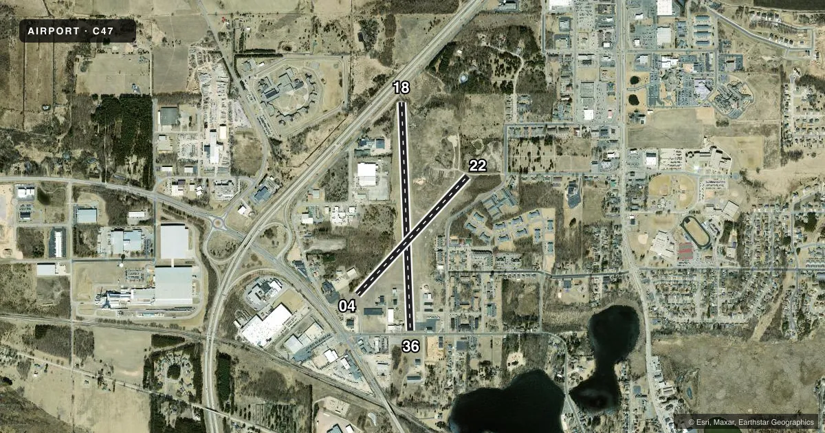
Runways & pattern
Full pagePattern entry · RWY 22
LEFT TRAFFIC| Runway | Heading (°M) | Length | Surface | Traffic |
|---|---|---|---|---|
| 18/36 | 175° / 355° | 3,770 ft | ASPH | Standard L |
| 04/22Favored | 40° / 220° | 2,668 ft | ASPH | Standard L |
Runway end performance
| End | TORA | TODA | ASDA | LDA | VGSI | Approach lights | Obstruction |
|---|---|---|---|---|---|---|---|
| 18 | — | — | — | — | PAPI 2-box left(3.75°) | — | 2', road, 200' from thr, 20' R of cntrln, slope 0 |
| 36 | — | — | — | — | — | — | 63', trees, 325' from thr, 220' R of cntrln, slope 1 |
| 04 | — | — | — | — | — | — | 15', road, 200' from thr, 80' R of cntrln, slope 0 |
| 22 | — | — | — | — | — | — | 58', trees, 814' from thr, 164' R of cntrln, slope 10 |
Declared distances in feet. TORA = takeoff run available, TODA = takeoff distance, ASDA = accelerate-stop, LDA = landing distance.
Airport sketch
Runways drawn to scale from FAA survey coordinates, rendered over satellite imagery. Not for navigation.
Approaches & charts
Services on the field
Fuel grades, oxygen, maintenance, ramp storage and lighting — as declared to the FAA by the airport operator.
Fuel & services
- Fuel
- 100LLUL91
- Oxygen (bottled)
- Not available
- Oxygen (bulk)
- Not available
- Airframe repair
- Not available
- Power plant repair
- Not available
- Other services
- INSTR
Ramp & ground
- Transient storage
- Tie-down
- Hangar
- Landing fee
- No fee published
- Customs
- Not available
- Beacon schedule
- SS-SR
- Beacon
- White / Green (civil land)(WG)
- Wind indicator
- Yes
- Segmented circle
- Yes
Fuel & FBOs
Cheapest 100LL and Jet A on the field and nearby. Always confirm with the FBO before taxi.
Airport notes
Surface conditions, obstructions, local procedures, lighting outages and other notes published with each FAA cycle.
General notes
- DEER ON & INVOF OF ARPT.
- RWY 36 LRG HNGRS & TREE 200 FT W OF MAY CAUSE WIND SHEAR WITH STRONG NW WINDS.
- POWERLINE 110 FT AGL 1580 FT FM DSPLCD THLD RY 36.
- FOR CD CTC MADISON APP/DEP CON AT 608-249-8240. WHEN MADISON APCH CLSD, FOR CD CTC CHICAGO ARTCC AT 630-906-8921.
Fuel notes
- 100LLFUEL AVBL 24 HRS WITH CREDIT CARD.
Runway surface & condition
- 04/22RWY NOT PLOWED DURG WINTER, CFM COND WITH AMGR.
- 18/36MIRL NSTD. RWY 18 FIRST 100 FT NOT LGTD; RWY 36 FIRST 193 FT NOT LGTD.
Approach & departure obstructions
- 0430 FT TREES 40 FT FM RWY END; 100 FT L.
- 182 FT RD AT RWY END; 170 FT RIGHT.
- 226 FT TRRN AT THR; 90 FT L.
- 3614 FT RD 42 FT FM RWY END; 28 FT POLE 30 FT FM RWY END, 125 FT L.
- 04CTLG OBSTN EXCEEDS A 45 DEG SLP.
- 18APCH RATIO 20:1 TO DSPLCD THR.
- 36APCH RATIO 10:1 TO DSPLCD THR; 63 FT TREES 587 FT FM DSPLCD THR, 220 L AND 105 FT PLINE 1576 FT FM DSPLCD THR, 70 FT L.
Other notes
- EXISTED PRIOR TO 1959.
- CONFIRM AVBL WITH AMGR.
- MANAGEREXT 104.
VFR map & nearby airports
VFR sectional. Tap any ICAO chip to open that airport.
Key facts · C47
Answer card- ICAO
- C47
- Name
- PORTAGE MUNI
- Location
- PORTAGE, WISCONSIN
- Elevation
- 824.8 ft MSL
- Traffic pattern altitude
- 1,824.8 ft MSL (1,000 AGL)
- Control tower
- Non-towered (use CTAF)
- Total runways
- 2
- Longest runway
- 18/36 · 3,770 ft
- Published ILS approaches
- 0
- Published frequencies
- 6
- Magnetic variation
- 3°
- Current flight rules
- VFR
- Current wind
- 210° at 9 kt
- Favored runway now
- RWY 22
Portage Muni sits in Portage, Wisconsin at 824.8 ft MSL. It has two asphalt runways. The longest is 18/36 at 3,770 ft. The field is non-towered. CTAF and UNICOM are both 122.7. No ILS approaches are published here.
Pattern altitude is not published. Use the standard 1,000 ft AGL for light piston traffic unless the current Chart Supplement says otherwise. That puts the traffic pattern at about 1,825 ft MSL based on the field elevation. The airport sits in a part of Wisconsin where winter surface conditions matter. Runway 04/22 is not plowed during winter. Confirm runway condition with the airport manager before you go.
Portage Municipal Airport is the on-field FBO. It carries 100LL. 24-hour self-serve credit card fuel is published. Call (608) 566-1343 for current availability. Published remarks also flag obstacles near both runway ends on 18/36. Runway 36 has a power line near the departure end. It also has large hangars and a tree west of the runway that may create wind shear with strong northwest winds. For clearance delivery, Madison Approach or Departure Control handles the field when open. If they are closed, Chicago ARTCC is listed for clearance delivery. Check the current Chart Supplement before flying in if you need any noise or operational details beyond the published remarks.