METAR & TAF 63C
63C does not publish a METAR.
Showing the nearest reporting station: KISW (ALEXANDER FLD SOUTH WOOD COUNTY) · 24.1 NM away. Conditions at 63C may differ.
METAR · KISW
Observed 02:54Z
KISW 260254Z AUTO 21003KT 10SM OVC024 24/21 A2992 RMK AO2 SLP127 T02390206 53006
- Wind
- 210° @ 3 kt
- Visibility
- 10 SM
- Temp / Dew
- 24°C / 21°C
- Altimeter
- 29.92 inHg
- Clouds
- OVC
- Density alt
- 2,294 ft
- Ceiling
- 2,400 ft AGL
- Rules
- MVFR
Airport info & contacts
Manager on record, flight service, ARTCC, attendance schedule and pattern altitude — published by the FAA and refreshed every 28 days.
Location
- From city
- 1 NM E
- VFR sectional
- CHICAGO
- ARTCC
- ZAU · CHICAGO
- NOTAM facility
- GRB (NOTAM-D)
Airport manager
- Name
- KYLE PATTERSON
- Phone
- 608-339-4201
- Address
- 401 ADAMS ST, STE 10, FRIENDSHIP WI 53934
Flight service · Hours
- FSS GRB
- GREEN BAY1-800-WX-BRIEF
- Attendance
- Unattended
Frequencies
Tap any row to copy the frequency to your clipboard.
Runways & pattern
Full pagePattern entry · RWY 26
LEFT TRAFFIC| Runway | Heading (°M) | Length | Surface | Traffic |
|---|---|---|---|---|
| 15/33 | 152° / 332° | 3,398 ft | ASPH | Standard L |
| 08/26Favored | 79° / 259° | 2,780 ft | TURF | Standard L |
Runway end performance
| End | TORA | TODA | ASDA | LDA | VGSI | Approach lights | Obstruction |
|---|---|---|---|---|---|---|---|
| 15 | — | — | — | — | PAPI 2-box left(3°) | — | 34', trees, 700' from thr, 285' R of cntrln, slope 14 |
| 33 | — | — | — | — | PAPI 2-box left(3°) | — | 59', trees, 630' from thr, 300' R of cntrln, slope 7 |
Declared distances in feet. TORA = takeoff run available, TODA = takeoff distance, ASDA = accelerate-stop, LDA = landing distance.
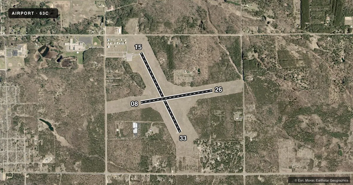
Airport sketch
Runways drawn to scale from FAA survey coordinates, rendered over satellite imagery. Not for navigation.
Approaches & charts
Services on the field
Fuel grades, oxygen, maintenance, ramp storage and lighting — as declared to the FAA by the airport operator.
Fuel & services
- Fuel
- 100LL
- Oxygen (bottled)
- Not available
- Oxygen (bulk)
- Not available
- Airframe repair
- Not available
- Power plant repair
- Not available
Ramp & ground
- Transient storage
- Tie-down
- Landing fee
- No fee published
- Customs
- Not available
- Lighting schedule
- SEE RMK
- Beacon schedule
- SS-SR
- Beacon
- White / Green (civil land)(WG)
- Wind indicator
- Lighted
- Segmented circle
- Yes
Fuel & FBOs
Cheapest 100LL and Jet A on the field and nearby. Always confirm with the FBO before taxi.
Airport notes
Surface conditions, obstructions, local procedures, lighting outages and other notes published with each FAA cycle.
General notes
- ULTRALIGHT ACT ON & INVOF ARPT.
- ACFT DEP RWY 15 REQD TO TURN TO HDG OF 180 DEG AFT TAKEOFF.
- FOR CD CTC CHICAGO ARTCC AT 630-906-8921.
- CROP DUSTING ACT ON & INVOF ARPT.
Lighting notes
- MIRL RWY 15/33 PRESET TO LOW SS-SR; TO INCR INTST & ACTVT REILS RWY 15 & 33 - CTAF.
Fuel notes
- 100LLFUEL AVBL H24 VIA CREDIT CARD.
Runway surface & condition
- 08/26CLSD DEC 1 - APR 1.
Approach & departure obstructions
- 08MKD WITH WHITE CONES.
- 26MKD WITH WHITE CONES.
- 15OPER CONSLY.
- 33OPER CONSLY.
VFR map & nearby airports
VFR sectional. Tap any ICAO chip to open that airport.
Key facts · 63C
Answer card- ICAO
- 63C
- Name
- ADAMS COUNTY LEGION FLD
- Location
- FRIENDSHIP (ADAMS), WISCONSIN
- Elevation
- 979.2 ft MSL
- Traffic pattern altitude
- 1,979.2 ft MSL (1,000 AGL)
- Control tower
- Non-towered (use CTAF)
- Total runways
- 2
- Longest runway
- 15/33 · 3,398 ft
- Published ILS approaches
- 0
- Published frequencies
- 3
- Magnetic variation
- 1°
- Current flight rules
- MVFR
- Current wind
- 210° at 3 kt
- Favored runway now
- RWY 26
Adams County Legion Fld (63C) sits near Friendship in Adams County, Wisconsin. Field elevation is 979.2 ft MSL. The airport has two runways. The longest is runway 15/33 at 3,398 ft. Runway 08/26 is 2,780 ft turf. There is no control tower. Pattern altitude is not published, so verify the current traffic pattern in the FAA Chart Supplement before you go. No ILS approaches are published here.
Adams County Airport is the on-field FBO. It carries 100LL. Published remarks say 100LL is available 24 hours a day by credit card. That is useful for late arrivals or early departures. Runway 08/26 is closed from December 1 to April 1. If you plan to use runway 15, be ready for the published departure turn to heading 180 degrees after takeoff. Visual glide slope indicators operate continuously on runway 15. On runway 33, the visual glide slope indicators also operate continuously. Medium intensity runway lights on 15/33 are preset low from sunset to sunrise. Use the CTAF to increase intensity or activate the runway end identifier lights.
This field also has ultralight activity in and near the airport. Crop dusting activity is also reported in the area. That makes a careful traffic scan important. Clearance delivery is handled through Chicago ARTCC by phone when needed. Check the current Chart Supplement for any other local procedures before flying in.