METAR & TAF KISW
Current METAR
Observed 12:54Z
KISW 271254Z AUTO 21006KT 10SM CLR 26/24 A2974 RMK AO2 SLP061 T02610239
- Wind
- 210° @ 6 kt
- Visibility
- 10 SM
- Temp / Dew
- 26°C / 24°C
- Altimeter
- 29.74 inHg
- Clouds
- CLR
- Density alt
- 2,809 ft
- Ceiling
- Unlimited
- Rules
- VFR
Airport info & contacts
Manager on record, flight service, ARTCC, attendance schedule and pattern altitude — published by the FAA and refreshed every 28 days.
Location
- From city
- 1 NM S
- VFR sectional
- GREEN BAY
- ARTCC
- ZMP · MINNEAPOLIS
- NOTAM facility
- ISW (NOTAM-D)
Airport manager
- Name
- JEREMY SICKLER
- Phone
- (715) 423-0330
- Address
- 3620 1ST ST SOUTH, WISCONSIN RAPIDS WI 54494
Flight service · Hours
- FSS GRB
- GREEN BAY1-800-WX-BRIEF
- Attendance
- 0700-1700
Frequencies
Tap any row to copy the frequency to your clipboard.
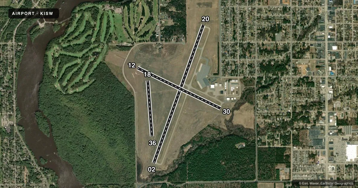
Runways & pattern
Full pagePattern entry · RWY 20
LEFT TRAFFIC| Runway | Heading (°M) | Length | Surface | Traffic |
|---|---|---|---|---|
| 02/20Favored | 19° / 199° | 5,500 ft | ASPH | Standard L |
| 12/30 | 115° / 295° | 3,472 ft | ASPH | Standard L |
| 18/36 | 175° / 355° | 2,089 ft | TURF | Standard L |
Runway end performance
| End | TORA | TODA | ASDA | LDA | VGSI | Approach lights | Obstruction |
|---|---|---|---|---|---|---|---|
| 02 | — | — | — | — | PAPI 4-box left(3°) | — | 15', trees, 250' from thr, 215' R of cntrln, slope 3 |
| 20 | — | — | — | — | PAPI 4-box left(3.5°) | — | 68', tree, 1560' from thr, 330' R of cntrln, slope 20 |
| 30 | — | — | — | — | PAPI 4-box left(4°) | — | — |
Declared distances in feet. TORA = takeoff run available, TODA = takeoff distance, ASDA = accelerate-stop, LDA = landing distance.
Airport sketch
Runways drawn to scale from FAA survey coordinates, rendered over satellite imagery. Not for navigation.
Approaches & charts
Services on the field
Fuel grades, oxygen, maintenance, ramp storage and lighting — as declared to the FAA by the airport operator.
Fuel & services
- Fuel
- 100LLAA+
- Oxygen (bottled)
- Not available
- Oxygen (bulk)
- Not available
- Airframe repair
- Not available
- Power plant repair
- Not available
- Other services
- CHTR,INSTR,RNTL
Ramp & ground
- Transient storage
- Tie-down
- Hangar
- Landing fee
- No fee published
- Customs
- Not available
- Lighting schedule
- SEE RMK
- Beacon schedule
- SS-SR
- Beacon
- White / Green (civil land)(WG)
- Wind indicator
- Lighted
- Segmented circle
- Yes
Fuel & FBOs
Cheapest 100LL and Jet A on the field and nearby. Always confirm with the FBO before taxi.
Airport notes
Surface conditions, obstructions, local procedures, lighting outages and other notes published with each FAA cycle.
General notes
- BIRDS ON & INVOF ARPT.
- ULTRALIGHT ACFT OPRG ON & INVOF ARPT.
- FOR CD IF UNA TO CTC ON FSS FREQ, CTC MINNEAPOLIS ARTCC AT 651-463-5588.
Lighting notes
- MIRL RWY 02/20 PRESET TO LOW SS-SR, TO INCR INTST AND ACTVT REIL RWY 02 & 20; PAPI RWY 02, 20 & 30; MIRL RWY 12/30 - CTAF.
Fuel notes
- 100LL24 HR SELF SVC FUEL AVBL WITH CREDIT CARD.
Approach & departure obstructions
- 18MKD WITH YELLOW METAL TRIANGLES.
- 36MKD WITH YELLOW METAL TRIANGLES.
Other notes
- MANAGERJSICKLER@WIRAPIDS.GOV.
- OWNERALSO VILLAGE OF PORT EDWARDS; TOWN OF GRAND RAPIDS, CITY OF NEKOOSA.
- MANAGERAFT HRS SVC CALL 715-741-2114
VFR map & nearby airports
VFR sectional. Tap any ICAO chip to open that airport.
Key facts · KISW
Answer card- ICAO
- KISW
- Name
- ALEXANDER FLD SOUTH WOOD COUNTY
- Location
- WISCONSIN RAPIDS, WISCONSIN
- Elevation
- 1,021.2 ft MSL
- Traffic pattern altitude
- 2,021.2 ft MSL (1,000 AGL)
- Control tower
- Non-towered (use CTAF)
- Total runways
- 3
- Longest runway
- 02/20 · 5,500 ft
- Published ILS approaches
- 0
- Published frequencies
- 2
- Magnetic variation
- 1°
- Current flight rules
- VFR
- Current wind
- 210° at 6 kt
- Favored runway now
- RWY 20
Alexander Fld South Wood County is in Wisconsin Rapids, Wisconsin. The field elevation is 1,021.2 ft MSL. It has three runways. The longest is runway 02/20 at 5,500 ft. There is no control tower. CTAF and UNICOM are both 122.8. No ILS approaches are published here. Pattern altitude is not published, so use the standard 1,000 ft AGL for light piston traffic unless local procedures say otherwise.
Alexander Field is on the field. It carries 100LL, Jet A and Jet A Prist. The field also has 24-hour self-serve 100LL with credit card access. Runway 02/20 lighting is preset low from sunset to sunrise. Runway end identifier lights are available on 02 and 20. PAPI is published on 02, 20 and 30. Runway 12/30 lights are activated by CTAF. Runway 18 and runway 36 are marked with yellow metal triangles.
This is an uncontrolled airport with ultralight activity reported on and near the field. Birds are also reported in the area. If you need clearance delivery and cannot reach Flight Service, the Chart Supplement says to contact Minneapolis ARTCC at 651-463-5588. Check the current Chart Supplement before you go for any updated operating notes or local restrictions.