METAR & TAF KDAF
KDAF does not publish a METAR.
Showing the nearest reporting station: KISW (ALEXANDER FLD SOUTH WOOD COUNTY) · 22.3 NM away. Conditions at KDAF may differ.
METAR · KISW
Observed 12:54Z
KISW 271254Z AUTO 21006KT 10SM CLR 26/24 A2974 RMK AO2 SLP061 T02610239
- Wind
- 210° @ 6 kt
- Visibility
- 10 SM
- Temp / Dew
- 26°C / 24°C
- Altimeter
- 29.74 inHg
- Clouds
- CLR
- Density alt
- 2,683 ft
- Ceiling
- Unlimited
- Rules
- VFR
Airport info & contacts
Manager on record, flight service, ARTCC, attendance schedule and pattern altitude — published by the FAA and refreshed every 28 days.
Location
- From city
- 1 NM NW
- VFR sectional
- GREEN BAY
- ARTCC
- ZAU · CHICAGO
- NOTAM facility
- GRB (NOTAM-D)
Airport manager
- Name
- JACK JASINSKI
- Phone
- 608-547-3411
- Address
- W6827 20TH STREET W, NECEDAH WI 54646
Flight service · Hours
- FSS GRB
- GREEN BAY1-800-WX-BRIEF
- Attendance
- Unattended
Frequencies
Tap any row to copy the frequency to your clipboard.
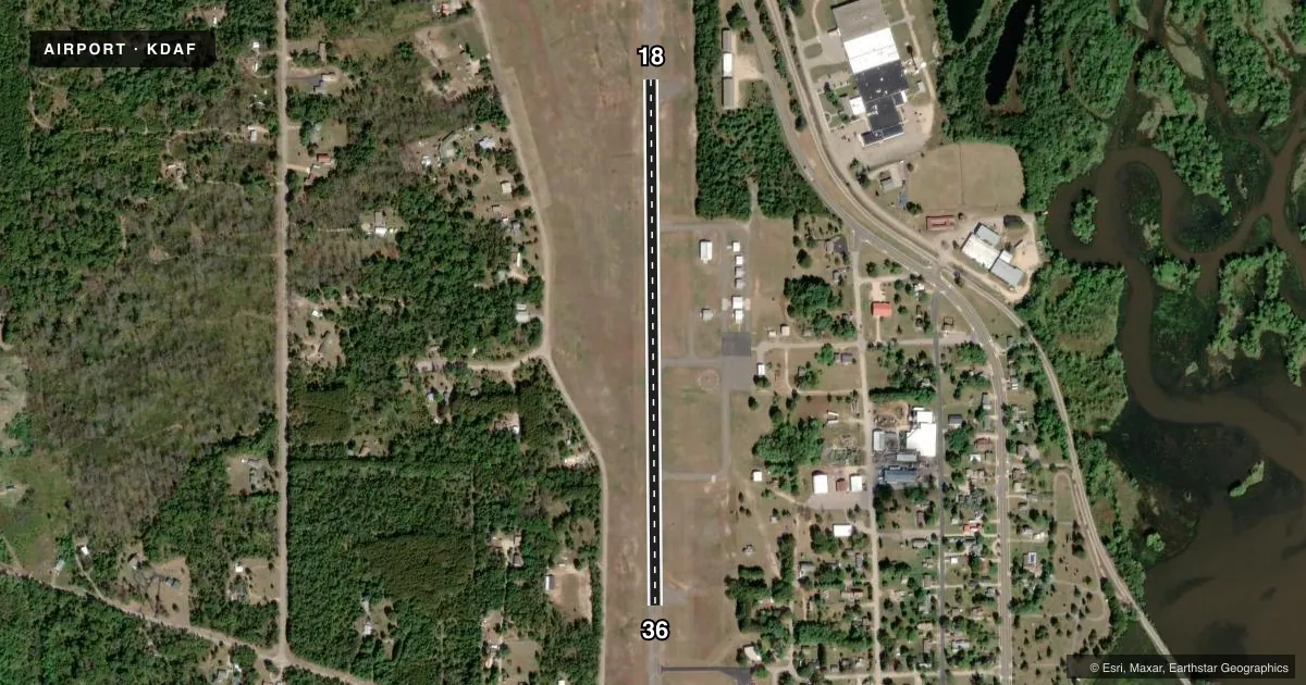
Runways & pattern
Full pagePattern entry · RWY 18
LEFT TRAFFICRunway end performance
| End | TORA | TODA | ASDA | LDA | VGSI | Approach lights | Obstruction |
|---|---|---|---|---|---|---|---|
| 18 | — | — | — | — | — | — | 40', trees, 200' from thr, 250' R of cntrln, slope 0 |
| 36 | — | — | — | — | — | — | 15', road, 307' from thr, 264' R of cntrln, slope 7 |
Declared distances in feet. TORA = takeoff run available, TODA = takeoff distance, ASDA = accelerate-stop, LDA = landing distance.
Airport sketch
Runways drawn to scale from FAA survey coordinates, rendered over satellite imagery. Not for navigation.
Approaches & charts
Services on the field
Fuel grades, oxygen, maintenance, ramp storage and lighting — as declared to the FAA by the airport operator.
Fuel & services
- Fuel
- Not available
- Oxygen (bottled)
- Not available
- Oxygen (bulk)
- Not available
- Airframe repair
- Minor
- Power plant repair
- Minor
Ramp & ground
- Transient storage
- Tie-down
- Landing fee
- No fee published
- Lighting schedule
- SEE RMK
- Beacon schedule
- SS-SR
- Beacon
- White / Green (civil land)(WG)
- Wind indicator
- Lighted
- Segmented circle
- Yes
Fuel & FBOs
Cheapest 100LL and Jet A on the field and nearby. Always confirm with the FBO before taxi.
Airport notes
Surface conditions, obstructions, local procedures, lighting outages and other notes published with each FAA cycle.
General notes
- DURG WINTER MONTHS CALL 608-547-3411 BFR LNDG TO DTRM STATUS.
- FOR CD CTC CHICAGO ARTCC AT 630-906-8921.
- DEER & MIGRATORY BIRDS ON & INVOF ARPT.
Lighting notes
- ACTVT LIRL RWY 18/36 - CTAF.
Approach & departure obstructions
- 1840 FT TREES 0 - 200 FT FM RWY END, 237 FT L.
- 18CTRLG OBSTN EXCEEDS 45 DEG SLP.
Other notes
- VFR OPNS ONLY; OBSTNS ARE REMOVED OR LWRD ON RWY ENDS OR THLDS DSPLCD TO PRVD 20:1 CLNC.
- MANAGERNECEDAHADMIN@NECEDAH.US.
- OWNEREXT 2.
VFR map & nearby airports
VFR sectional. Tap any ICAO chip to open that airport.
Key facts · KDAF
Answer card- ICAO
- KDAF
- Name
- NECEDAH
- Location
- NECEDAH, WISCONSIN
- Elevation
- 919.3 ft MSL
- Traffic pattern altitude
- 1,919.3 ft MSL (1,000 AGL)
- Control tower
- Non-towered (use CTAF)
- Total runways
- 1
- Longest runway
- 18/36 · 2,721 ft
- Published ILS approaches
- 0
- Published frequencies
- 4
- Magnetic variation
- 1°
- Current flight rules
- VFR
- Current wind
- 210° at 6 kt
- Favored runway now
- RWY 18
Necedah Airport sits in Necedah, Wisconsin. Field elevation is 919.3 ft MSL. The airport has one runway. Runway 18/36 is 2,721 ft long with asphalt surface. It is a non-towered field. CTAF and UNICOM are both 122.7. No ILS approaches are published here.
Pattern altitude is not published in the facts. Use the standard 1,000 ft AGL for light piston traffic unless the current Chart Supplement says otherwise. The published remarks matter here. This is VFR only. Low intensity runway lights on 18/36 are activated by keying the CTAF. There are also obstruction notes near runway 18. Deer and migratory birds are reported on and near the airport, so keep a close scan on arrival and departure. Winter operations also need a check before you go. Call the listed number before landing in winter months to confirm field status.
There are no on-field FBOs listed in the facts. Contact the airport operator directly before arrival if you need fuel or other services. For clearance delivery, the published contact is Chicago ARTCC. The field sits in a rural area with a short single runway, so plan with the runway length and local wildlife in mind.