METAR & TAF Y72
Y72 does not publish a METAR.
Showing the nearest reporting station: KCMY (SPARTA/FORT MC COY) · 11.2 NM away. Conditions at Y72 may differ.
METAR · KCMY
Observed 12:55Z
KCMY 271255Z AUTO 00000KT 10SM CLR 26/24 A2971 RMK AO2 SLP057 T02640244 $
- Wind
- 000° @ 0 kt
- Visibility
- 10 SM
- Temp / Dew
- 26°C / 24°C
- Altimeter
- 29.71 inHg
- Clouds
- CLR
- Density alt
- 2,778 ft
- Ceiling
- Unlimited
- Rules
- VFR
Airport info & contacts
Manager on record, flight service, ARTCC, attendance schedule and pattern altitude — published by the FAA and refreshed every 28 days.
Location
- From city
- 1 NM E
- VFR sectional
- CHICAGO
- ARTCC
- ZAU · CHICAGO
- NOTAM facility
- GRB (NOTAM-D)
Airport manager
- Name
- JOE KUBE
- Phone
- 608-344-1626
- Address
- 819 SUPERIOR AVE., TOMAH WI 54660
Flight service · Hours
- FSS GRB
- GREEN BAY1-800-WX-BRIEF
- Attendance
- Unattended
Frequencies
Tap any row to copy the frequency to your clipboard.
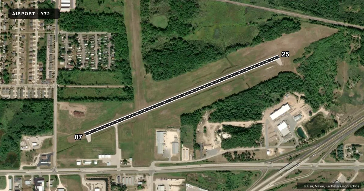
Runways & pattern
Full pagePattern entry · RWY 07
LEFT TRAFFICRunway end performance
| End | TORA | TODA | ASDA | LDA | VGSI | Approach lights | Obstruction |
|---|---|---|---|---|---|---|---|
| 07 | — | — | — | — | PAPI 2-box left(3°) | — | — |
| 25 | — | — | — | — | PAPI 2-box left(3°) | — | 30', trees, 675' from thr, 150' R of cntrln, slope 15 |
Declared distances in feet. TORA = takeoff run available, TODA = takeoff distance, ASDA = accelerate-stop, LDA = landing distance.
Airport sketch
Runways drawn to scale from FAA survey coordinates, rendered over satellite imagery. Not for navigation.
Approaches & charts
Services on the field
Fuel grades, oxygen, maintenance, ramp storage and lighting — as declared to the FAA by the airport operator.
Fuel & services
- Fuel
- 100LL
- Oxygen (bottled)
- Not available
- Oxygen (bulk)
- Not available
- Airframe repair
- Not available
- Power plant repair
- Not available
Ramp & ground
- Transient storage
- Tie-down
- Landing fee
- No fee published
- Customs
- Not available
- Lighting schedule
- SEE RMK
- Beacon schedule
- SS-SR
- Beacon
- White / Green (civil land)(WG)
- Wind indicator
- Lighted
- Segmented circle
- Yes
Fuel & FBOs
Cheapest 100LL and Jet A on the field and nearby. Always confirm with the FBO before taxi.
Airport notes
Surface conditions, obstructions, local procedures, lighting outages and other notes published with each FAA cycle.
General notes
- DEER & BIRDS ON & INVOF AIRPORT.
- FOR CD CTC CHICAGO ARTCC AT 630-906-8921.
Lighting notes
- ACTVT REIL RWY 07/25; PAPI RYS 07/25; MIRL RWY 07/25 - CTAF. MIRL RWY 07/25 PRESET TO LOW SS-SR, TO INCR INTST - CTAF.
Fuel notes
- 100LLSELF SVC FUEL AVBL H24 VIA CREDIT CARD.
VFR map & nearby airports
VFR sectional. Tap any ICAO chip to open that airport.
Key facts · Y72
Answer card- ICAO
- Y72
- Name
- BLOYER FLD
- Location
- TOMAH, WISCONSIN
- Elevation
- 966.1 ft MSL
- Traffic pattern altitude
- 1,966.1 ft MSL (1,000 AGL)
- Control tower
- Non-towered (use CTAF)
- Total runways
- 1
- Longest runway
- 07/25 · 3,900 ft
- Published ILS approaches
- 0
- Published frequencies
- 3
- Magnetic variation
- 0°
- Current flight rules
- VFR
- Current wind
- 000° at 0 kt
- Favored runway now
- –
Bloyer Field sits in Tomah, Wisconsin. Field elevation is 966.1 ft MSL. The airport has one runway. Runway 07/25 is 3,900 ft asphalt, which is the longest runway on the field. There is no control tower. CTAF is 122.9. Approach and departure service is listed on 135.25 and 244.875 under VOLK.
No ILS approaches are published here. Pattern altitude is not published, so use the standard 1,000 ft AGL for light piston traffic unless current published guidance says otherwise. The on-field FBO is Bloyer Field. It carries AVGAS 100LL. Self-service fuel is available 24 hours by credit card. Runway end identifier lights are on runway 07/25. Precision approach path indicators are installed on both runway ends. Medium intensity runway lights are on runway 07/25 and are controlled by CTAF. They start at low intensity from sunset to sunrise. They can be increased on CTAF.
For a first-time arrival, watch for deer and birds in the airport area. Clearance delivery is handled through Chicago ARTCC at 630-906-8921. Check the current FAA Chart Supplement for any updated remarks before you go.