METAR & TAF KLSE
Current METAR
Observed 12:53Z
KLSE 271253Z 20006KT 10SM FEW080 27/23 A2972 RMK AO2 SLP049 T02720233
- Wind
- 200° @ 6 kt
- Visibility
- 10 SM
- Temp / Dew
- 27°C / 23°C
- Altimeter
- 29.72 inHg
- Clouds
- FEW
- Density alt
- 2,501 ft
- Ceiling
- Unlimited
- Rules
- VFR
Airport info & contacts
Manager on record, flight service, ARTCC, attendance schedule and pattern altitude — published by the FAA and refreshed every 28 days.
Location
- From city
- 4 NM NW
- VFR sectional
- CHICAGO
- ARTCC
- ZMP · MINNEAPOLIS
- NOTAM facility
- LSE (NOTAM-D)
Airport manager
- Name
- LAUREN KOSS
- Phone
- 608-789-7456
- Address
- 2850 AIRPORT ROAD, LA CROSSE WI 54603-1264
Flight service · Hours
- FSS GRB
- GREEN BAY1-800-WX-BRIEF
- Attendance
- 0600-2100
Frequencies
Tap any row to copy the frequency to your clipboard.
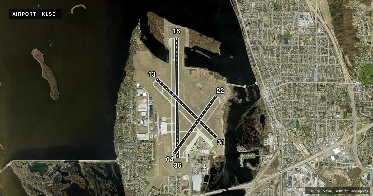
Runways & pattern
Full pagePattern entry · RWY 22
LEFT TRAFFIC| Runway | Heading (°M) | Length | Surface | Traffic |
|---|---|---|---|---|
| 18/36 | 178° / 358° | 8,742 ft | CONC | Standard L |
| 13/31 | 133° / 313° | 6,050 ft | ASPH | Standard L |
| 04/22Favored | 35° / 215° | 5,199 ft | ASPH | Standard L |
Runway end performance
| End | TORA | TODA | ASDA | LDA | VGSI | Approach lights | Obstruction |
|---|---|---|---|---|---|---|---|
| 18 | 8,105' | 8,742' | 8,536' | 8,536' | PAPI 4-box left(3°) | MALSR | 69', tree, 3443' from thr, 790' R of cntrln, slope 47 |
| 36 | 8,742' | 8,742' | 8,564' | 7,433' | VASI 4-box left(3°) | — | 48', tree, 1522' from thr, 424' R of cntrln, slope 28 |
| 13 | 5,310' | 5,310' | 5,310' | 5,310' | VASI 4-box left(3°) | — | 68', trees, 1995' from thr, 327' R of cntrln, slope 26 |
| 31 | 6,050' | 6,050' | 6,050' | 5,310' | VASI 4-box left(3.85°) | — | 40', trees, 1250' from thr, 350' R of cntrln, slope 26 |
| 04 | 5,199' | 5,199' | 5,199' | 5,199' | PAPI 4-box left(4°) | — | 47', pole, 1516' from thr, 320' R of cntrln, slope 28 |
| 22 | 5,199' | 5,199' | 5,199' | 5,199' | PAPI 4-box left(4°) | — | 43', trees, 994' from thr, 350' R of cntrln, slope 18 |
Declared distances in feet. TORA = takeoff run available, TODA = takeoff distance, ASDA = accelerate-stop, LDA = landing distance.
Airport sketch
Runways drawn to scale from FAA survey coordinates, rendered over satellite imagery. Not for navigation.
Approaches & charts
ILS · 1
Services on the field
Fuel grades, oxygen, maintenance, ramp storage and lighting — as declared to the FAA by the airport operator.
Fuel & services
- Fuel
- 100LLA
- Oxygen (bottled)
- Not available
- Oxygen (bulk)
- Not available
- Airframe repair
- Major
- Power plant repair
- Major
- Other services
- AFRT,CHTR,INSTR,RNTL,SALES
Ramp & ground
- Transient storage
- Tie-down
- Hangar
- Landing fee
- No fee published
- Customs
- Not available
- Lighting schedule
- SEE RMK
- Beacon schedule
- SS-SR
- Beacon
- White / Green (civil land)(WG)
- Wind indicator
- Lighted
- Segmented circle
- Yes
Fuel & FBOs
Cheapest 100LL and Jet A on the field and nearby. Always confirm with the FBO before taxi.
Airport notes
Surface conditions, obstructions, local procedures, lighting outages and other notes published with each FAA cycle.
General notes
- TOWER, 1390 FT AGL 6NM SW.
- NUMEROUS TOWERS UP TO 836 FT AGL; 4NM SE.
- DEER; WATERFOWL & OTHER BIRDS ON & INVOF ARPT. HVY CONCENTRATIONS OF WATERFOWL SPRING & FALL.
- HLDG PSN FOR THE WEST SIDE OF RWY 36 APCH END IS SET BACK ON TWY C. SEE HS-1 ON ARPT DIAGRAM.
- COLD TEMPERATURE AIRPORT. ALTITUDE CORRECTION REQUIRED AT OR BELOW -21C.
- RWY INCURSION RISK. PILOTS ARE REMINDED TO REVIEW ARPT HOT SPOT INFO BFR TXG FOR DEP AND BFR LNDG. SEE TPP ARPT DIAGRAM AND CHART SUPPL SXN ON HOT SPOTS FOR ADDNL INFO.
- WRONG RWY ARRIVAL RISK, RWY 4 AND 36 APCH ENDS ARE CLOSELY ALIGNED. SEE TPP ARPT DIAGRAM.
- FOR CD WHEN ATCT IS CLSD CTC ON FSS ON RCO FREQ; IF UNA CTC MINNEAPOLIS ARTCC AT 651-463-5588.
- TWY A BTN RWY 13/31 AND TWY A4; TWY A4 NOT AVBL FOR SKEDD ACR OPNS WITH MORE THAN 9 PAX SEATS OR UNSKED ACR OPNS GTR THAN 30 PAX SEATS.
- 48 HR PPR FOR UNSKED ACR OPS GTR THAN 30 PAX SEATS, CALL AMGR.
Lighting notes
- WHEN ATCT CLSD MIRL RWY 13/31 PRESET LOW INTST; TO INCR INTST & ACTVT MALSR RWY 18; REIL RWY 13, 31, 36; MIRL RWY 13/31; HIRL RWY 18/36, RWY 04/22 - CTAF. PAPI RWY 04, 18, & 22; VASI RWY 13, 31, & 36 OPR CONSLY.
Runway surface & condition
- 04/22PCR VALUE: 330/F/A/X/T
- 13/31PCR VALUE: 630/F/A/X/T
- 18/36PCR VALUE: 630/R/B/W/T
- 04/22RWY 04/22 NOT AVBL FOR PART 121/PART 380 OPS WITH SKED PAX CARRYING OPS MORE THAN 9 PAX SEATS AND NON-SKED PAX CARRYING OPS MORE THAN 30 PAX SEATS.
Approach & departure obstructions
- 31VASI UNUSBL BYD 9 DEGS RIGHT OF CNTRLN.
- 31RWY 31 APCH RATIO 24:1 AT DSPLCD THLD.
- 36RY 36 APCH RATIO 50:1 AT DSPLCD THLD.
Other notes
- 1FOR ATTENDANT OTHER HOURS CALL 608-783-8359.
VFR map & nearby airports
VFR sectional. Tap any ICAO chip to open that airport.
Key facts · KLSE
Answer card- ICAO
- KLSE
- Name
- LA CROSSE RGNL
- Location
- LA CROSSE, WISCONSIN
- Elevation
- 655.4 ft MSL
- Traffic pattern altitude
- 1,655.4 ft MSL (1,000 AGL)
- Control tower
- Towered · 0600-2100
- Total runways
- 3
- Longest runway
- 18/36 · 8,742 ft
- Published ILS approaches
- 1
- Published frequencies
- 6
- Magnetic variation
- 1°
- Current flight rules
- VFR
- Current wind
- 200° at 6 kt
- Favored runway now
- RWY 22
La Crosse Rgnl sits in La Crosse, Wisconsin. Field elevation is 655.4 ft MSL. The airport has three runways. The longest is runway 18/36 at 8,742 ft. The field is towered from 0600 to 2100. When the tower is closed, use CTAF and expect the runway lighting system to be preset low on runway 13/31. The field has one ILS approach, which serves runway 18.
Pattern altitude is not published in the facts. Use 1,000 ft AGL for light piston traffic unless the current FAA Chart Supplement or tower gives you a different instruction. That puts the standard pattern at about 1,655 ft MSL here. Colgan Air Services is on the field. It carries 100LL and Jet A Pr. Call the FBO directly for current service details.
There are a few operational items worth briefing before you taxi. The airport has a runway incursion risk noted in the Chart Supplement. Review the airport diagram and hot spots before departure and before landing. Runways 04 and 36 are closely aligned. Wrong-runway risk is real. There are also bird hazards on and near the airport, with heavier waterfowl activity in spring and fall. Runway 36 and runway 31 have published obstruction notes at the displaced thresholds. Check the current FAA Chart Supplement and the airport diagram before you go.