METAR & TAF 55Y
55Y does not publish a METAR.
Showing the nearest reporting station: KONA (WINONA MUNI/MAX CONRAD FLD) · 16.6 NM away. Conditions at 55Y may differ.
METAR · KONA
Observed 08:35Z
KONA 270835Z AUTO 00000KT 10SM CLR 23/23 A2974 RMK AO2 TSNO
- Wind
- 000° @ 0 kt
- Visibility
- 10 SM
- Temp / Dew
- 23°C / 23°C
- Altimeter
- 29.74 inHg
- Clouds
- CLR
- Density alt
- 2,685 ft
- Ceiling
- Unlimited
- Rules
- VFR
Airport info & contacts
Manager on record, flight service, ARTCC, attendance schedule and pattern altitude — published by the FAA and refreshed every 28 days.
Location
- From city
- 3 NM W
- VFR sectional
- CHICAGO
- ARTCC
- ZMP · MINNEAPOLIS
- NOTAM facility
- PNM (NOTAM-D)
Airport manager
- Name
- ROGER KNUTSON
- Phone
- 507-864-2664
- Address
- 101 N MILL ST, RUSHFORD MN 55971-9195
Flight service · Hours
- FSS PNM
- PRINCETON1-800-WX-BRIEF
- Attendance
- Unattended
Frequencies
Tap any row to copy the frequency to your clipboard.
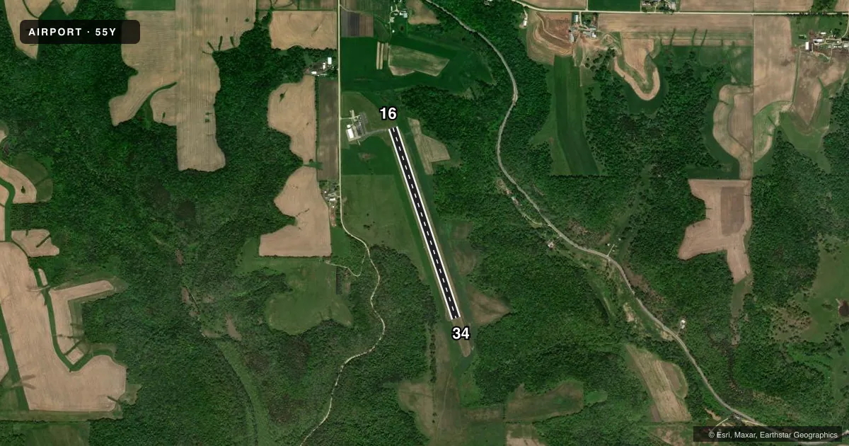
Runways & pattern
Full pagePattern entry · RWY 16
LEFT TRAFFICRunway end performance
| End | TORA | TODA | ASDA | LDA | VGSI | Approach lights | Obstruction |
|---|---|---|---|---|---|---|---|
| 16 | — | — | — | — | PAPI 2-box left(3°) | — | — |
| 34 | — | — | — | — | PAPI 2-box left(3°) | — | — |
Declared distances in feet. TORA = takeoff run available, TODA = takeoff distance, ASDA = accelerate-stop, LDA = landing distance.
Airport sketch
Runways drawn to scale from FAA survey coordinates, rendered over satellite imagery. Not for navigation.
Approaches & charts
Services on the field
Fuel grades, oxygen, maintenance, ramp storage and lighting — as declared to the FAA by the airport operator.
Fuel & services
- Fuel
- 100LL
- Oxygen (bottled)
- Not available
- Oxygen (bulk)
- Not available
- Airframe repair
- Not available
- Power plant repair
- Not available
Ramp & ground
- Transient storage
- Tie-down
- Landing fee
- No fee published
- Customs
- Not available
- Lighting schedule
- SEE RMK
- Beacon schedule
- SS-SR
- Beacon
- White / Green (civil land)(WG)
- Wind indicator
- Lighted
- Segmented circle
- No
Fuel & FBOs
Cheapest 100LL and Jet A on the field and nearby. Always confirm with the FBO before taxi.
Airport notes
Surface conditions, obstructions, local procedures, lighting outages and other notes published with each FAA cycle.
General notes
- DEER ON & INVOF ARPT.
- FOR CD CTC ROCHESTER APCH AT 507-424-8111.
Lighting notes
- ACTVT PAPI RWY 16 & 34; MIRL RWY 16/34 - CTAF.
Fuel notes
- 100LLFUEL AVBL SELF SVC VIA CREDIT CARD.
Other notes
- THIS AIRPORT HAS BEEN SURVEYED BY THE NATIONAL GEODETIC SURVEY.
- MANAGERRUSHFORD@ACEGROUP.CC.
VFR map & nearby airports
VFR sectional. Tap any ICAO chip to open that airport.
Key facts · 55Y
Answer card- ICAO
- 55Y
- Name
- RUSHFORD MUNI/ROBERT W BUNKE FLD
- Location
- RUSHFORD, MINNESOTA
- Elevation
- 1,211 ft MSL
- Traffic pattern altitude
- 2,211 ft MSL (1,000 AGL)
- Control tower
- Non-towered (use CTAF)
- Total runways
- 1
- Longest runway
- 16/34 · 3,200 ft
- Published ILS approaches
- 0
- Published frequencies
- 3
- Magnetic variation
- 1°
- Current flight rules
- VFR
- Current wind
- 000° at 0 kt
- Favored runway now
- –
Rushford Muni/Robert W Bunke Fld sits in Rushford, Minnesota. Field elevation is 1,211 ft MSL. The airport has one runway. Runway 16/34 is 3,200 ft of asphalt. There is no control tower. CTAF is 122.9. Rochester Approach handles clearance delivery and approach or departure support on 119.8 and 251.125.
No ILS approaches are published here. Pattern altitude is not published, so use the standard 1,000 ft AGL for light piston operations unless the current Chart Supplement says otherwise. That puts the traffic pattern at 2,211 ft MSL. The runway lighting is pilot controlled on CTAF. PAPI is available for both runway directions. Self-serve 100LL is available by credit card at the on-field FBO, Rushford Municipal Airport. Deer are reported on and near the airport. Keep a sharp scan on taxi, takeoff and landing.
This is a small non-towered field with a single short asphalt runway. Check density altitude and takeoff performance if you are operating a heavier airplane or flying on a warm day. If you need a clearance, call Rochester Approach at 507-424-8111 before departure. For any current noise or operational restrictions, verify the current FAA Chart Supplement before you fly.