METAR & TAF KFKA
Current METAR
Observed 03:15Z
KFKA 270315Z AUTO 21007KT 10SM CLR 27/25 A2982 RMK AO2
- Wind
- 210° @ 7 kt
- Visibility
- 10 SM
- Temp / Dew
- 27°C / 25°C
- Altimeter
- 29.82 inHg
- Clouds
- CLR
- Density alt
- 3,147 ft
- Ceiling
- Unlimited
- Rules
- VFR
Airport info & contacts
Manager on record, flight service, ARTCC, attendance schedule and pattern altitude — published by the FAA and refreshed every 28 days.
Location
- From city
- 4 NM W
- VFR sectional
- CHICAGO
- ARTCC
- ZMP · MINNEAPOLIS
- NOTAM facility
- FKA (NOTAM-D)
Airport manager
- Name
- PAM SCHROEDER
- Phone
- 507-765-3854
- Address
- 909 HOUSTON ST NW, PRESTON MN 55965-1080
Flight service · Hours
- FSS PNM
- PRINCETON1-800-WX-BRIEF
- Attendance
- Unattended
Frequencies
Tap any row to copy the frequency to your clipboard.
Runways & pattern
Full pagePattern entry · RWY 29
LEFT TRAFFICRunway end performance
| End | TORA | TODA | ASDA | LDA | VGSI | Approach lights | Obstruction |
|---|---|---|---|---|---|---|---|
| 11 | — | — | — | — | PAPI 2-box left(3°) | — | — |
| 29 | — | — | — | — | PAPI 2-box left(3°) | — | — |
Declared distances in feet. TORA = takeoff run available, TODA = takeoff distance, ASDA = accelerate-stop, LDA = landing distance.
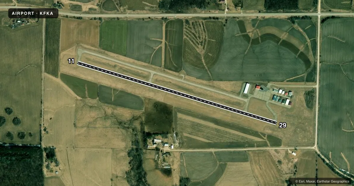
Airport sketch
Runways drawn to scale from FAA survey coordinates, rendered over satellite imagery. Not for navigation.
Approaches & charts
Services on the field
Fuel grades, oxygen, maintenance, ramp storage and lighting — as declared to the FAA by the airport operator.
Fuel & services
- Fuel
- 100LL
- Oxygen (bottled)
- Not available
- Oxygen (bulk)
- Not available
- Airframe repair
- Not available
- Power plant repair
- Not available
- Other services
- INSTR,RNTL,SALES
Ramp & ground
- Transient storage
- Tie-down
- Landing fee
- No fee published
- Customs
- Not available
- Lighting schedule
- SEE RMK
- Beacon schedule
- SS-SR
- Beacon
- White / Green (civil land)(WG)
- Wind indicator
- Lighted
- Segmented circle
- No
Fuel & FBOs
Cheapest 100LL and Jet A on the field and nearby. Always confirm with the FBO before taxi.
Airport notes
Surface conditions, obstructions, local procedures, lighting outages and other notes published with each FAA cycle.
General notes
- ULTRALIGHTS ON & INVOF ARPT.
- FOR CD CTC ROCHESTER APCH AT 507-424-8111.
Lighting notes
- ACTVT REIL RWY 11 & 29; PAPI RWY 11 & 29; MIRL RWY 11/29 - CTAF.
Fuel notes
- 100LLFUEL AVBL H24 SELF SVC VIA CREDIT CARD.
VFR map & nearby airports
VFR sectional. Tap any ICAO chip to open that airport.
Key facts · KFKA
Answer card- ICAO
- KFKA
- Name
- FILLMORE COUNTY
- Location
- PRESTON, MINNESOTA
- Elevation
- 1,276.7 ft MSL
- Traffic pattern altitude
- 2,276.7 ft MSL (1,000 AGL)
- Control tower
- Non-towered (use CTAF)
- Total runways
- 1
- Longest runway
- 11/29 · 4,001 ft
- Published ILS approaches
- 0
- Published frequencies
- 3
- Magnetic variation
- 1°
- Current flight rules
- VFR
- Current wind
- 210° at 7 kt
- Favored runway now
- RWY 29
Fillmore County Airport sits near Preston, Minnesota. The field elevation is 1,276.7 ft MSL. It has one runway. Runway 11/29 is 4,001 ft of asphalt, which is the longest runway on the field. There is no control tower. Rochester Approach handles IFR services on 119.8 and 251.125. Clearance delivery is handled through Rochester Approach at 507-424-8111.
No ILS approaches are published here. Pattern altitude is not published, so use the standard 1,000 ft AGL for light piston traffic unless the current FAA Chart Supplement says otherwise. The on-field FBO is Fillmore County Airport. It carries 100LL. Fuel is available 24 hours a day through self-service credit card. Runway end identifier lights are active on 11 and 29. Precision approach path indicators are also on both runway ends. Medium intensity runway lights are on runway 11/29 and are controlled by CTAF.
For a first-time arrival, pay attention to the field elevation. Density altitude can matter more than it does at lower airports. Ultralights are on and in the vicinity of the airport, so keep a sharp lookout in the pattern and on taxi. CTAF is 122.9.