METAR & TAF KCHU
KCHU does not publish a METAR.
Showing the nearest reporting station: KLSE (LA CROSSE RGNL) · 20.1 NM away. Conditions at KCHU may differ.
METAR · KLSE
Observed 15:53Z
KLSE 271553Z 24008KT 10SM CLR 32/26 A2967 RMK AO2 SLP032 T03220261
- Wind
- 240° @ 8 kt
- Visibility
- 10 SM
- Temp / Dew
- 32°C / 26°C
- Altimeter
- 29.67 inHg
- Clouds
- CLR
- Density alt
- 3,812 ft
- Ceiling
- Unlimited
- Rules
- VFR
Airport info & contacts
Manager on record, flight service, ARTCC, attendance schedule and pattern altitude — published by the FAA and refreshed every 28 days.
Location
- From city
- 3 NM S
- VFR sectional
- CHICAGO
- ARTCC
- ZMP · MINNEAPOLIS
- NOTAM facility
- PNM (NOTAM-D)
Airport manager
- Name
- BRIAN POGODZINSKI
- Phone
- 507-725-3925
- Address
- 1124 E WASHINGTON ST, CALEDONIA MN 55921-1623
Flight service · Hours
- FSS PNM
- PRINCETON1-800-WX-BRIEF
- Attendance
- Unattended
Frequencies
Tap any row to copy the frequency to your clipboard.
Runways & pattern
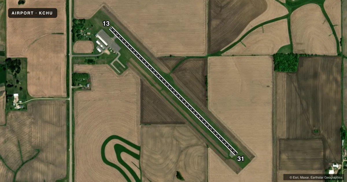
Full pagePattern entry · RWY 31
LEFT TRAFFICAirport sketch
Runways drawn to scale from FAA survey coordinates, rendered over satellite imagery. Not for navigation.
Approaches & charts
Services on the field
Fuel grades, oxygen, maintenance, ramp storage and lighting — as declared to the FAA by the airport operator.
Fuel & services
- Fuel
- 100LL
- Oxygen (bottled)
- Not available
- Oxygen (bulk)
- Not available
- Airframe repair
- Not available
- Power plant repair
- Not available
Ramp & ground
- Transient storage
- Tie-down
- Landing fee
- No fee published
- Customs
- Not available
- Lighting schedule
- SEE RMK
- Beacon schedule
- SS-SR
- Beacon
- White / Green (civil land)(WG)
- Wind indicator
- Lighted
- Segmented circle
- No
Fuel & FBOs
Cheapest 100LL and Jet A on the field and nearby. Always confirm with the FBO before taxi.
Airport notes
Surface conditions, obstructions, local procedures, lighting outages and other notes published with each FAA cycle.
General notes
- TURF TWY 25 FT WIDE
- TURF TWY UNEVEN
- FOR CD CTC MINNEAPOLIS ARTCC AT 651-463-5588.
Lighting notes
- MIRL RWY 13/31 PRESET LOW INTS SS-SR; TO INCR INTS & ACTVT MIRL RWY 13/31 - CTAF.
Fuel notes
- 100LL24 HR CREDIT CARD SVC AVBL.
Other notes
- THIS AIRPORT HAS BEEN SURVEYED BY THE NATIONAL GEODETIC SURVEY.
VFR map & nearby airports
VFR sectional. Tap any ICAO chip to open that airport.
Key facts · KCHU
Answer card- ICAO
- KCHU
- Name
- HOUSTON COUNTY
- Location
- CALEDONIA, MINNESOTA
- Elevation
- 1,179 ft MSL
- Traffic pattern altitude
- 2,179 ft MSL (1,000 AGL)
- Control tower
- Non-towered (use CTAF)
- Total runways
- 1
- Longest runway
- 13/31 · 3,499 ft
- Published ILS approaches
- 0
- Published frequencies
- 1
- Magnetic variation
- 1°
- Current flight rules
- VFR
- Current wind
- 240° at 8 kt
- Favored runway now
- RWY 31
Houston County Airport is in Caledonia, Minnesota. The field elevation is 1,179 ft MSL. It has one runway. Runway 13/31 is 3,499 ft long with an asphalt surface. There is no control tower. CTAF is 122.9.
No ILS approaches are published here. Pattern altitude is not published, so use the standard 1,000 ft AGL for light piston traffic unless the current Chart Supplement says otherwise. The on-field FBO is Houston County. It carries 100LL. Twenty-four hour credit card self-service is available for 100LL fuel.
A few operational details matter here. The turf taxiway is uneven and it is 25 feet wide. Medium intensity runway lights on 13/31 are preset to low intensity from sunset to sunrise. Use the CTAF to increase intensity and activate the lights. For clearance delivery, contact Minneapolis ARTCC at 651-463-5588. This is a non-towered field, so expect self-announce traffic and keep a close eye out on the taxiway and runway environment.