METAR & TAF KONA
Current METAR
Observed 16:15Z
KONA 271615Z AUTO 29009KT 10SM SCT022 32/26 A2968 RMK AO2 TSNO
- Wind
- 290° @ 9 kt
- Visibility
- 10 SM
- Temp / Dew
- 32°C / 26°C
- Altimeter
- 29.68 inHg
- Clouds
- SCT
- Density alt
- 3,151 ft
- Ceiling
- Unlimited
- Rules
- VFR
Airport info & contacts
Manager on record, flight service, ARTCC, attendance schedule and pattern altitude — published by the FAA and refreshed every 28 days.
Location
- From city
- 3 NM NW
- VFR sectional
- GREEN BAY
- ARTCC
- ZMP · MINNEAPOLIS
- NOTAM facility
- ONA (NOTAM-D)
Airport manager
- Name
- BRIAN DEFRANG
- Phone
- 507-457-8269
- Address
- BOX 378, WINONA MN 55987
Flight service · Hours
- FSS PNM
- PRINCETON1-800-WX-BRIEF
- Attendance
- MON-FRI · 0700-1630
Frequencies
Tap any row to copy the frequency to your clipboard.
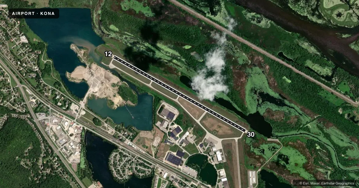
Runways & pattern
Full pagePattern entry · RWY 30
RIGHT TRAFFICRunway end performance
| End | TORA | TODA | ASDA | LDA | VGSI | Approach lights | Obstruction |
|---|---|---|---|---|---|---|---|
| 12 | 5,679' | 5,679' | 5,199' | 5,199' | PAPI 4-box left(3°) | — | — |
| 30 | 5,679' | 5,679' | 5,679' | 5,199' | PAPI 4-box left(3°) | MALSR | — |
Declared distances in feet. TORA = takeoff run available, TODA = takeoff distance, ASDA = accelerate-stop, LDA = landing distance.
Airport sketch
Runways drawn to scale from FAA survey coordinates, rendered over satellite imagery. Not for navigation.
Approaches & charts
ILS · 1
Services on the field
Fuel grades, oxygen, maintenance, ramp storage and lighting — as declared to the FAA by the airport operator.
Fuel & services
- Fuel
- 100LLA
- Oxygen (bottled)
- Not available
- Oxygen (bulk)
- Not available
- Airframe repair
- Major
- Power plant repair
- Major
- Other services
- CHTR,INSTR,RNTL,SALES,SURV
Ramp & ground
- Transient storage
- Tie-down
- Hangar
- Landing fee
- No fee published
- Customs
- Not available
- Lighting schedule
- SEE RMK
- Beacon schedule
- SS-SR
- Beacon
- White / Green (civil land)(WG)
- Wind indicator
- Lighted
- Segmented circle
- No
Fuel & FBOs
Cheapest 100LL and Jet A on the field and nearby. Always confirm with the FBO before taxi.
Airport notes
Surface conditions, obstructions, local procedures, lighting outages and other notes published with each FAA cycle.
General notes
- DEER AND WATERFOWL ON AND INVOF ARPT.
- FOR CD IF UNA TO CTC ON FSS FREQ, CTC MINNEAPOLIS ARTCC AT 651-463-5588.
- COLD TEMPERATURE AIRPORT. ALTITUDE CORRECTION REQUIRED AT OR BELOW -29C.
Lighting notes
- MIRL RY 12/30 PRESET ON LOW INTST, TO INCR INTST & ACTVT MALSR RY 30; REIL RY 12; PAPI RY 12/30; MIRL RY 12/30 - CTAF.
Fuel notes
- 100LLFOR SVC AFT HRS CALL 507-429-6321 OR 507-313-8720.
Runway surface & condition
- 12/30RUNWAY 30 IS CALM WIND RUNWAY
Approach & departure obstructions
- 12RWY 30 HAS 75 FT TREE 2449 FT FM RWY END, 635 FT R.
VFR map & nearby airports
VFR sectional. Tap any ICAO chip to open that airport.
Key facts · KONA
Answer card- ICAO
- KONA
- Name
- WINONA MUNI/MAX CONRAD FLD
- Location
- WINONA, MINNESOTA
- Elevation
- 656.2 ft MSL
- Traffic pattern altitude
- 1,656.2 ft MSL (1,000 AGL)
- Control tower
- Non-towered (use CTAF)
- Total runways
- 1
- Longest runway
- 12/30 · 5,679 ft
- Published ILS approaches
- 1
- Published frequencies
- 2
- Magnetic variation
- 1°
- Current flight rules
- VFR
- Current wind
- 290° at 9 kt
- Favored runway now
- RWY 30
KONA is in Winona, Minnesota. The field elevation is 656.2 ft MSL. It has one runway, 12/30, which is 5,679 ft long. There is no control tower. CTAF and UNICOM are both 122.8. The published pattern altitude is not listed, so use the standard 1,000 ft AGL for light piston traffic unless the current Chart Supplement says otherwise.
One ILS approach is published for runway 30. The runway lighting is tied to CTAF control. Runway 30 is the calm wind runway. The remarks also call out a tree on the runway 30 side. It sits 2,449 ft from the runway end and 635 ft right. Deer and waterfowl are reported on and near the airport, so keep a sharp scan on departure and in the pattern.
Win Air is on the field. It carries 100LL and Jet A. After-hours fuel service is available by phone. This is also a cold temperature airport. Altitude correction is required at or below minus 29 degrees Celsius. If you need clearance delivery and cannot reach Flight Service, the published backup is Minneapolis ARTCC. For a first-time arrival, plan for an uncontrolled field with one paved runway, one ILS and wildlife on the movement area.