METAR & TAF KRGK
Current METAR
Observed 04:55Z
KRGK 270455Z AUTO 00000KT 10SM CLR 24/23 A2977 RMK AO2
- Wind
- 000° @ 0 kt
- Visibility
- 10 SM
- Temp / Dew
- 24°C / 23°C
- Altimeter
- 29.77 inHg
- Clouds
- CLR
- Density alt
- 2,231 ft
- Ceiling
- Unlimited
- Rules
- VFR
Airport info & contacts
Manager on record, flight service, ARTCC, attendance schedule and pattern altitude — published by the FAA and refreshed every 28 days.
Location
- From city
- 3 NM NE
- VFR sectional
- GREEN BAY
- ARTCC
- ZMP · MINNEAPOLIS
- NOTAM facility
- RGK (NOTAM-D)
Airport manager
- Name
- SHAWN BLANEY
- Phone
- 651-385-3653
- Address
- 229 TYLER RD N, RED WING MN 55066-1826
Flight service · Hours
- FSS GRB
- GREEN BAY1-800-WX-BRIEF
- Attendance
- MON-SAT · 0800-1700
- SUN · 1000-1600
Frequencies
Tap any row to copy the frequency to your clipboard.
Runways & pattern
Full pagePattern entry · RWY 09
LEFT TRAFFICRunway end performance
| End | TORA | TODA | ASDA | LDA | VGSI | Approach lights | Obstruction |
|---|---|---|---|---|---|---|---|
| 09 | — | — | — | — | PAPI 4-box left(3°) | MALSR | — |
| 27 | — | — | — | — | PAPI 4-box left(3.7°) | ODALS | — |
Declared distances in feet. TORA = takeoff run available, TODA = takeoff distance, ASDA = accelerate-stop, LDA = landing distance.
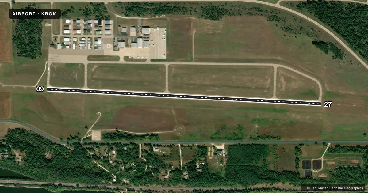
Airport sketch
Runways drawn to scale from FAA survey coordinates, rendered over satellite imagery. Not for navigation.
Approaches & charts
ILS · 1
Services on the field
Fuel grades, oxygen, maintenance, ramp storage and lighting — as declared to the FAA by the airport operator.
Fuel & services
- Fuel
- 100LLA
- Oxygen (bottled)
- HIGH/LOW
- Oxygen (bulk)
- HIGH/LOW
- Airframe repair
- Major
- Power plant repair
- Major
- Other services
- AVNCS,CHTR,INSTR,RNTL,SALES
Ramp & ground
- Transient storage
- Tie-down
- Hangar
- Landing fee
- No fee published
- Customs
- Not available
- Lighting schedule
- SEE RMK
- Beacon schedule
- SS-SR
- Beacon
- White / Green (civil land)(WG)
- Wind indicator
- Lighted
- Segmented circle
- Yes
Fuel & FBOs
Cheapest 100LL and Jet A on the field and nearby. Always confirm with the FBO before taxi.
Airport notes
Surface conditions, obstructions, local procedures, lighting outages and other notes published with each FAA cycle.
General notes
- ADMIN BLDG 715-594-3701.
- ARPT PHYS LCTN IS IN WISCONSIN.
- DEER ON & INVOF ARPT.
- FOR CD CTC MINNEAPOLIS APCH AT 612-713-4016.
Lighting notes
- ACTVT OR INCR INTST MALSR RWY 09; ODALS RWY 27; PAPI RWY 09 & 27; HIRL RWY 09/27 - CTAF. HIRL RWY 09/27 PRESET LOW INTST.
Fuel notes
- 100LLFUEL AVBL H24 VIA CREDIT CARD.
Other notes
- MANAGERARPT PHYS ADS: W7145 148TH AVE, BAY CITY, WI 54723-1100.
VFR map & nearby airports
VFR sectional. Tap any ICAO chip to open that airport.
Key facts · KRGK
Answer card- ICAO
- KRGK
- Name
- RED WING RGNL
- Location
- RED WING, MINNESOTA
- Elevation
- 778.1 ft MSL
- Traffic pattern altitude
- 1,778.1 ft MSL (1,000 AGL)
- Control tower
- Non-towered (use CTAF)
- Total runways
- 1
- Longest runway
- 09/27 · 5,010 ft
- Published ILS approaches
- 1
- Published frequencies
- 4
- Magnetic variation
- 2°
- Current flight rules
- VFR
- Current wind
- 000° at 0 kt
- Favored runway now
- –
Red Wing Rgnl sits near Red Wing, Minnesota. The airport physical location is in Wisconsin. Field elevation is 778.1 ft MSL. It has one runway, 09/27, at 5,010 ft of asphalt. The field is not towered. CTAF and UNICOM are both 123.05. Minneapolis Approach handles clearance delivery and approach work on 121.2 and 335.65.
There is one ILS approach. It serves runway 09. Pattern altitude is not published. Use the standard 1,000 ft AGL for light piston traffic unless the current Chart Supplement says otherwise. The runway lighting is pilot-controlled by CTAF. The MALSR on 09, the ODALS on 27, the PAPI on both ends and the HIRL can all be activated or brightened that way. The HIRL are preset to low intensity.
Blue Airways is on the field. It carries 100LL and Jet A. 100LL is available 24 hours a day by credit card. Watch for deer on and near the airport. That matters here, especially at dusk and at night. The airport address is W7145 148th Avenue, Bay City, Wisconsin 54723-1100. For clearance delivery, Minneapolis Approach can be reached at 612-726-9086.