METAR & TAF KRNH
Current METAR
Observed 13:10Z
KRNH 251310Z AUTO 19007KT 10SM BKN009 OVC015 21/19 A2989 RMK AO2 T02120193
- Wind
- 190° @ 7 kt
- Visibility
- 10 SM
- Temp / Dew
- 21°C / 19°C
- Altimeter
- 29.89 inHg
- Clouds
- OVC
- Density alt
- 1,995 ft
- Ceiling
- 900 ft AGL
- Rules
- IFR
Airport info & contacts
Manager on record, flight service, ARTCC, attendance schedule and pattern altitude — published by the FAA and refreshed every 28 days.
Location
- From city
- 2 NM N
- VFR sectional
- GREEN BAY
- ARTCC
- ZMP · MINNEAPOLIS
- NOTAM facility
- RNH (NOTAM-D)
Airport manager
- Name
- MIKE DEMULLING
- Phone
- 715-246-7735
- Address
- 156 E FIRST STREET, NEW RICHMOND WI 54017
Flight service · Hours
- FSS GRB
- GREEN BAY1-800-WX-BRIEF
- Attendance
- ALL
Frequencies
Tap any row to copy the frequency to your clipboard.
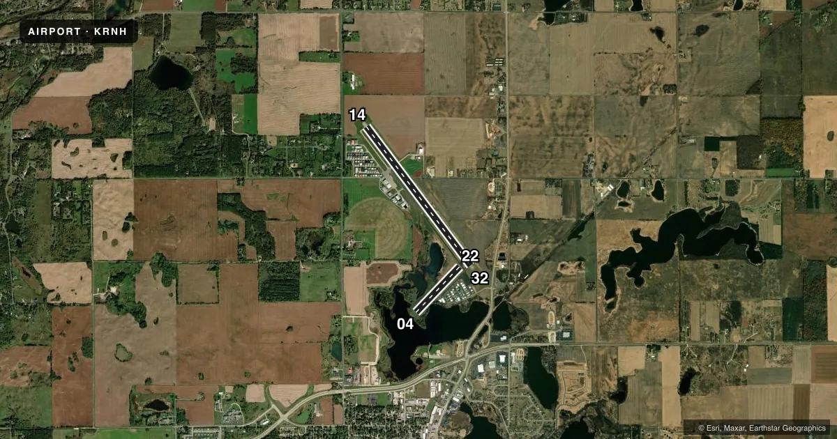
Runways & pattern
Full pagePattern entry · RWY 22
LEFT TRAFFIC| Runway | Heading (°M) | Length | Surface | Traffic |
|---|---|---|---|---|
| 14/32 | 141° / 321° | 5,507 ft | ASPH | Standard L |
| 04/22Favored | 42° / 222° | 2,006 ft | TURF | Standard L |
Runway end performance
| End | TORA | TODA | ASDA | LDA | VGSI | Approach lights | Obstruction |
|---|---|---|---|---|---|---|---|
| 14 | — | — | — | — | PAPI 4-box left(3°) | — | 54', tree, 1500' from thr, 230' R of cntrln, slope 24 |
| 32 | — | — | — | — | PAPI 4-box left(3°) | — | — |
Declared distances in feet. TORA = takeoff run available, TODA = takeoff distance, ASDA = accelerate-stop, LDA = landing distance.
Airport sketch
Runways drawn to scale from FAA survey coordinates, rendered over satellite imagery. Not for navigation.
Approaches & charts
Services on the field
Fuel grades, oxygen, maintenance, ramp storage and lighting — as declared to the FAA by the airport operator.
Fuel & services
- Fuel
- 100LLA
- Oxygen (bottled)
- Low pressure
- Oxygen (bulk)
- Not available
- Airframe repair
- Major
- Power plant repair
- Major
- Other services
- AVNCS,CHTR,INSTR,RNTL,SALES
Ramp & ground
- Transient storage
- Tie-down
- Hangar
- Landing fee
- No fee published
- Customs
- Not available
- Lighting schedule
- SEE RMK
- Beacon schedule
- SS-SR
- Beacon
- White / Green (civil land)(WG)
- Wind indicator
- Lighted
- Segmented circle
- Yes
Fuel & FBOs
Cheapest 100LL and Jet A on the field and nearby. Always confirm with the FBO before taxi.
Airport notes
Surface conditions, obstructions, local procedures, lighting outages and other notes published with each FAA cycle.
General notes
- DEER & BIRDS ON & INVOF ARPT.
- AEROBATIC PRACTICE AREA 4 NM NE OF ARPT.
- ULTRALIGHT ACTIVITY ON & INVOF ARPT.
- SEAPLANE TRAFFIC ADJACENT TO SOUTH SIDE OF ARPT.
- TURBO-JET TOUCH & GO NOT AUTHORIZED.
- BRIGHT LGTS FM BALL FIELDS 1/2 MI SOUTH DURG EVENINGS MAY THRU SEP.
- GCO AVBL ON FREQ 121.725 THRU MINNEAPOLIS APCH CTL.
- AUTOMOBILE AND PEDESTRIAN ACCESS ONTO ARPT PROPERTY RESTRICTED BY SECURITY FENCING AND GATES FM 2200-0600. CTC AMGR 715-246-7735 FOR ACCESS INSTRUCTIONS.
- 24-HR SELF SVC FUEL AVBL FOR CREDIT CARD USERS OR CALL 715-246-5338.
- FOR CD CTC MINNEAPOLIS APCH AT 612-713-4016.
Lighting notes
- MIRL RWY 14/32 PRESET ON LOW INTST; TO INCR INTST & ACTVT REIL RWY 14 & 32; PAPI 14 & 32; MIRL 14/32 - CTAF.
Runway surface & condition
- 04/22MARKED WITH WHITE CONES. OPEN TO SKI EQUIPPED ACFT WINTER MONTHS.
Approach & departure obstructions
- 32PAPI RWY 32 UNUSBL BYD 4 DEG R OF COURSE.
Other notes
- MANAGEREMAIL ADDRESS: MIKE@NRAIRPORT.COM (ALL LOWER CASE)
VFR map & nearby airports
VFR sectional. Tap any ICAO chip to open that airport.
Key facts · KRNH
Answer card- ICAO
- KRNH
- Name
- NEW RICHMOND RGNL
- Location
- NEW RICHMOND, WISCONSIN
- Elevation
- 997.9 ft MSL
- Traffic pattern altitude
- 1,997.9 ft MSL (1,000 AGL)
- Control tower
- Non-towered (use CTAF)
- Total runways
- 2
- Longest runway
- 14/32 · 5,507 ft
- Published ILS approaches
- 0
- Published frequencies
- 4
- Magnetic variation
- 2°
- Current flight rules
- IFR
- Current wind
- 190° at 7 kt
- Favored runway now
- RWY 22
New Richmond Rgnl is in New Richmond, Wisconsin. The field elevation is 997.9 ft MSL. It has two runways. The longest is 14/32 at 5,507 ft asphalt. Runway 04/22 is 2,006 ft turf. The airport is non-towered. Pattern altitude is not published, so verify the current traffic pattern in the FAA Chart Supplement before you go. No ILS approaches are published here.
East Metro Jet Center is on the field. It carries 100LL and Jet A. Twenty-four hour self-service fuel is available for credit card users or by calling the FBO. The airport sits under Minneapolis Approach coverage. GCO is available on 121.725 through Minneapolis Approach control. CTAF and UNICOM are both 122.975.
A few local items matter on a first visit. Access to the airport is restricted by fencing and gates from 2200 to 0600. Contact the airport manager for access instructions if you expect to arrive during that window. Deer and birds are reported on and near the airport. Seaplane traffic operates adjacent to the south side of the field. Runway 14/32 lighting is preset low. Use CTAF to increase intensity and activate the runway end identifier lights and PAPI. There is also an aerobatic practice area 4 NM northeast of the airport. Winter ski operations are allowed on runway 04/22.