METAR & TAF 3T3
3T3 does not publish a METAR.
Showing the nearest reporting station: KLUM (MENOMONIE MUNI/SCORE FLD) · 11.2 NM away. Conditions at 3T3 may differ.
METAR · KLUM
Observed 17:15Z
KLUM 271715Z AUTO 27010KT 10SM CLR 33/22 A2968 RMK AO2 T03340222 PWINO
- Wind
- 270° @ 10 kt
- Visibility
- 10 SM
- Temp / Dew
- 33°C / 22°C
- Altimeter
- 29.68 inHg
- Clouds
- CLR
- Density alt
- 3,657 ft
- Ceiling
- Unlimited
- Rules
- VFR
Airport info & contacts
Manager on record, flight service, ARTCC, attendance schedule and pattern altitude — published by the FAA and refreshed every 28 days.
Location
- From city
- 0 NM SE
- VFR sectional
- GREEN BAY
- ARTCC
- ZMP · MINNEAPOLIS
- NOTAM facility
- GRB (NOTAM-D)
Airport manager
- Name
- JOEL TIMBLIN
- Phone
- (218) 393-5264
- Address
- 803 AIRPORT DRIVE, BOYCEVILLE WI 54725
Flight service · Hours
- FSS GRB
- GREEN BAY1-800-WX-BRIEF
- Attendance
- UNATTND
Frequencies
Tap any row to copy the frequency to your clipboard.
Runways & pattern
Full pagePattern entry · RWY 26
LEFT TRAFFICRunway end performance
| End | TORA | TODA | ASDA | LDA | VGSI | Approach lights | Obstruction |
|---|---|---|---|---|---|---|---|
| 08 | — | — | — | — | PAPI 2-box left(4°) | — | — |
| 26 | — | — | — | — | PAPI 2-box left(3°) | — | — |
Declared distances in feet. TORA = takeoff run available, TODA = takeoff distance, ASDA = accelerate-stop, LDA = landing distance.
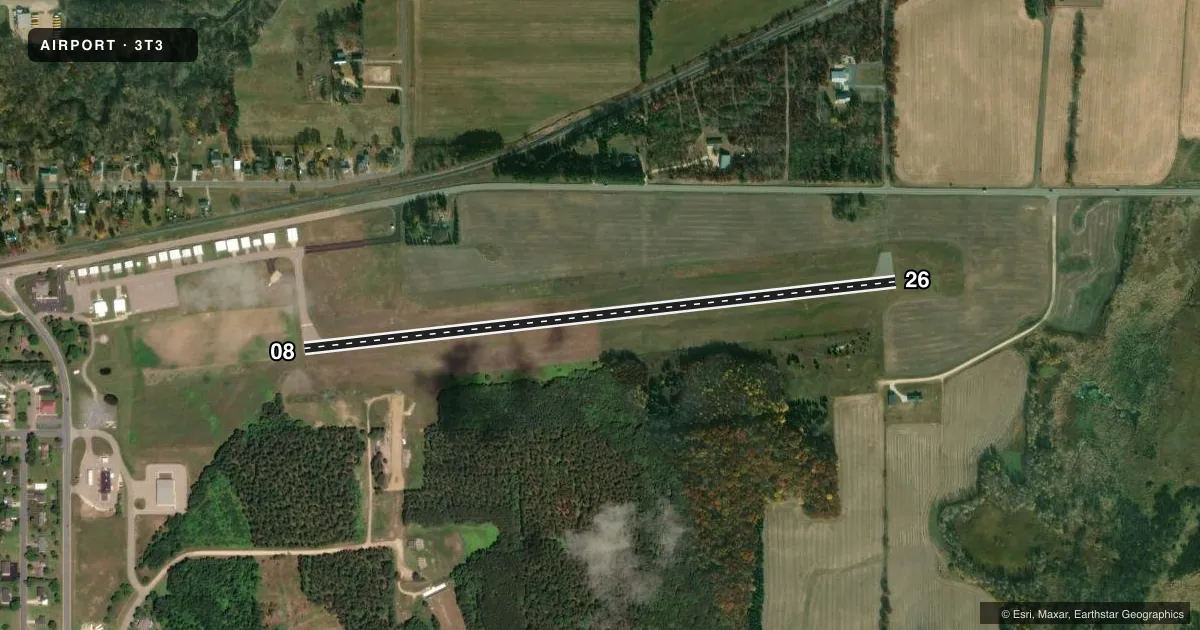
Airport sketch
Runways drawn to scale from FAA survey coordinates, rendered over satellite imagery. Not for navigation.
Approaches & charts
Services on the field
Fuel grades, oxygen, maintenance, ramp storage and lighting — as declared to the FAA by the airport operator.
Fuel & services
- Fuel
- 100LL
- Oxygen (bottled)
- Not available
- Oxygen (bulk)
- Not available
- Airframe repair
- Major
- Power plant repair
- Minor
- Other services
- INSTR
Ramp & ground
- Transient storage
- Tie-down
- Landing fee
- No fee published
- Lighting schedule
- SEE RMK
- Beacon schedule
- SS-SR
- Beacon
- White / Green (civil land)(WG)
- Wind indicator
- Lighted
- Segmented circle
- Yes
Fuel & FBOs
Cheapest 100LL and Jet A on the field and nearby. Always confirm with the FBO before taxi.
Airport notes
Surface conditions, obstructions, local procedures, lighting outages and other notes published with each FAA cycle.
General notes
- DEER ON & INVOF ARPT, PRIMARILY AFTER DUSK.
- FOR CD CTC MINNEAPOLIS ARTCC AT 651-463-5588.
Lighting notes
- MIRL RWY 08/26 PRESET TO LOW SS-SR; TO INCR INTST AND ACTVT REIL RWY 26; MIRL RWY 08/26 - CTAF.
Fuel notes
- 100LL24 HR SELF SVC FUEL AVBL WITH CREDIT CARD.
Other notes
- MANAGEREMAIL ADDRESS: MEDIC145@YAHOO.COM.
VFR map & nearby airports
VFR sectional. Tap any ICAO chip to open that airport.
Key facts · 3T3
Answer card- ICAO
- 3T3
- Name
- BOYCEVILLE MUNI
- Location
- BOYCEVILLE, WISCONSIN
- Elevation
- 967.1 ft MSL
- Traffic pattern altitude
- 1,967.1 ft MSL (1,000 AGL)
- Control tower
- Non-towered (use CTAF)
- Total runways
- 1
- Longest runway
- 08/26 · 3,299 ft
- Published ILS approaches
- 0
- Published frequencies
- 2
- Magnetic variation
- 0°
- Current flight rules
- VFR
- Current wind
- 270° at 10 kt
- Favored runway now
- RWY 26
Boyceville Muni sits in Boyceville, Wisconsin. Field elevation is 967.1 ft MSL. The airport has one runway. Runway 08/26 is 3,299 ft of asphalt, with magnetic headings 084° and 264°. There is no control tower. CTAF and UNICOM are both 122.8.
No ILS approaches are published here. Pattern altitude is not published, so use the standard 1,000 ft AGL for light piston operations unless the current FAA Chart Supplement says otherwise. The field has one on-field FBO, Boyceville Municipal Airport. It carries AVGAS 100LL. Twenty-four hour self-serve fuel is available with a credit card.
A few operational notes matter here. The runway lights on 08/26 are preset to low from sunset to sunrise. Use the CTAF to increase intensity. Use it also to activate the runway end identifier lights on runway 26. Deer are reported on and near the airport, mainly after dusk. If you need clearance delivery, contact Minneapolis ARTCC at 651-463-5588. For a first-time arrival, plan for an uncontrolled field with night lighting procedures that need a radio call. Watch for wildlife after dark.