METAR & TAF Y23
Current METAR
Observed 18:55Z
KY23 271855Z AUTO 33005G16KT 280V010 10SM SCT033 BKN038 33/23 A2970 RMK AO2 T03250229
- Wind
- 330° @ 5G16 kt
- Visibility
- 10 SM
- Temp / Dew
- 33°C / 23°C
- Altimeter
- 29.70 inHg
- Clouds
- BKN
- Density alt
- 3,742 ft
- Ceiling
- 3,800 ft AGL
- Rules
- VFR
Airport info & contacts
Manager on record, flight service, ARTCC, attendance schedule and pattern altitude — published by the FAA and refreshed every 28 days.
Location
- From city
- 1 NM SE
- VFR sectional
- GREEN BAY
- ARTCC
- ZMP · MINNEAPOLIS
- NOTAM facility
- GRB (NOTAM-D)
Airport manager
- Name
- MATT HUTZLER
- Phone
- 715-925-1036
- Address
- P O BOX 194, CHETEK WI 54728
Flight service · Hours
- FSS GRB
- GREEN BAY1-800-WX-BRIEF
- Attendance
- Unattended
Frequencies
Tap any row to copy the frequency to your clipboard.
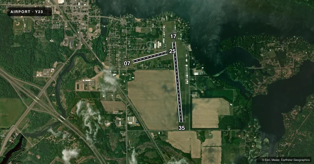
Runways & pattern
Full pagePattern entry · RWY 35
RIGHT TRAFFIC| Runway | Heading (°M) | Length | Surface | Traffic |
|---|---|---|---|---|
| 17/35Favored | 175° / 355° | 3,401 ft | ASPH | 35 R |
| 07/25 | 75° / 255° | 1,490 ft | TURF | 07 R |
Runway end performance
| End | TORA | TODA | ASDA | LDA | VGSI | Approach lights | Obstruction |
|---|---|---|---|---|---|---|---|
| 17 | — | — | — | — | PAPI 2-box left(4°) | — | 38', tree, 540' from thr, 165' R of cntrln, slope 8 |
| 35 | — | — | — | — | PAPI 2-box left(3°) | — | 13', road, 370' from thr, 0' R of cntrln, slope 13 |
| 07 | — | — | — | — | — | — | 75', trees, 835' from thr, 175' R of cntrln, slope 11 |
| 25 | — | — | — | — | — | — | 90', trees, 1000' from thr, 225' R of cntrln, slope 11 |
Declared distances in feet. TORA = takeoff run available, TODA = takeoff distance, ASDA = accelerate-stop, LDA = landing distance.
Airport sketch
Runways drawn to scale from FAA survey coordinates, rendered over satellite imagery. Not for navigation.
Approaches & charts
Services on the field
Fuel grades, oxygen, maintenance, ramp storage and lighting — as declared to the FAA by the airport operator.
Fuel & services
- Fuel
- 100LL
- Oxygen (bottled)
- Not available
- Oxygen (bulk)
- Not available
- Airframe repair
- Minor
- Power plant repair
- Minor
Ramp & ground
- Transient storage
- Tie-down
- Landing fee
- No fee published
- Lighting schedule
- SEE RMK
- Beacon schedule
- SS-SR
- Beacon
- White / Green (civil land)(WG)
- Wind indicator
- Lighted
- Segmented circle
- Yes
Fuel & FBOs
Cheapest 100LL and Jet A on the field and nearby. Always confirm with the FBO before taxi.
Airport notes
Surface conditions, obstructions, local procedures, lighting outages and other notes published with each FAA cycle.
General notes
- RY 17/35 MAY NOT BE PLOWED FOR 24 HRS AFT HVY SNOWFALL OR DRIFTING SNOW.
- RY 07/25 NOT PLOWED FOR SNOW, OPEN TO SKI EQUIPED AIRCRAFT.
- FOR CD CTC MINNEAPOLIS ARTCC AT 651-463-5588.
Lighting notes
- MIRL RWY 17/35 PRESET ON LOW SS-SR; TO INCR INTST & ACTVT REIL RWY 17 & 35; PAPI RWY 17 & 35; MIRL RWY 17/35 - CTAF.
Fuel notes
- 100LL24 HR SELF SVC FUEL AVBL WITH CREDIT CARD.
Approach & departure obstructions
- 17HANGAR 200 FT LEFT.
- 07MKD WITH YELLOW CONES.
- 25MKD WITH YELLOW CONES.
- 07APCH RATIO 13:1 TO DSPLCD THR, 75 FT TREES 1026 FT FM DSPLCD THR, 175 FT R; APCH RATIO 13:1 TO DSPLCD THR, 90 FT TREES 1200 FT FM DSPLCD THR, 225 FT L.
- 17APCH RATIO 20:1 TO DSPLCD THR.
Other notes
- MANAGEREMAIL: AIRPORTMANAGER@CITYOFCHETEKWI.US
VFR map & nearby airports
VFR sectional. Tap any ICAO chip to open that airport.
Key facts · Y23
Answer card- ICAO
- Y23
- Name
- CHETEK MUNI/SOUTHWORTH
- Location
- CHETEK, WISCONSIN
- Elevation
- 1,056 ft MSL
- Traffic pattern altitude
- 2,056 ft MSL (1,000 AGL)
- Control tower
- Non-towered (use CTAF)
- Total runways
- 2
- Longest runway
- 17/35 · 3,401 ft
- Published ILS approaches
- 0
- Published frequencies
- 1
- Magnetic variation
- 0°
- Current flight rules
- VFR
- Current wind
- 330° at 5 kt
- Favored runway now
- RWY 35
Chetek Muni/Southworth sits in Chetek, Wisconsin at 1,056 ft MSL. It has two runways. The longest is 17/35 at 3,401 ft asphalt. The other runway is 07/25 at 1,490 ft turf. There is no control tower, so plan to self-announce on CTAF 122.9. No ILS approaches are published here.
Pattern altitude is not published. Use the standard 1,000 ft AGL pattern unless local procedures or the current Chart Supplement say otherwise. For runway 17/35, the published lighting is preset low from sunset to sunrise. CTAF activation is used to increase intensity. It also turns on runway end identifier lights. PAPI is available for 17 and 35. The field also has 24-hour self-serve 100LL with a credit card through Chetek Southworth Municipal Airport. Call them at (715) 764-0554 for current field details.
A few operational notes matter here. Runway 17/35 may not be plowed for 24 hours after heavy snowfall or drifting snow. Runway 07/25 is not plowed for snow and is open to ski-equipped aircraft. There are trees near the 07 approach path. A hangar sits left of runway 17. For clearance delivery, contact Minneapolis ARTCC at 651-463-5588. This is a small non-towered field. Expect local traffic, short-field judgment and winter surface checks to matter more than anything else.