METAR & TAF KEAU
Current METAR
Observed 19:56Z
KEAU 271956Z 32012G22KT 10SM CLR 34/23 A2966 RMK AO2 SLP035 T03390228
- Wind
- 320° @ 12G22 kt
- Visibility
- 10 SM
- Temp / Dew
- 34°C / 23°C
- Altimeter
- 29.66 inHg
- Clouds
- CLR
- Density alt
- 3,735 ft
- Ceiling
- Unlimited
- Rules
- VFR
Airport info & contacts
Manager on record, flight service, ARTCC, attendance schedule and pattern altitude — published by the FAA and refreshed every 28 days.
Location
- From city
- 3 NM N
- VFR sectional
- GREEN BAY
- ARTCC
- ZMP · MINNEAPOLIS
- NOTAM facility
- EAU (NOTAM-D)
Airport manager
- Name
- CHARITY ZICH
- Phone
- 715-839-6241
- Address
- 3800 STARR AVE, EAU CLAIRE WI 54703
Flight service · Hours
- FSS GRB
- GREEN BAY1-800-WX-BRIEF
- Attendance
- 0700-2100
Frequencies
Tap any row to copy the frequency to your clipboard.
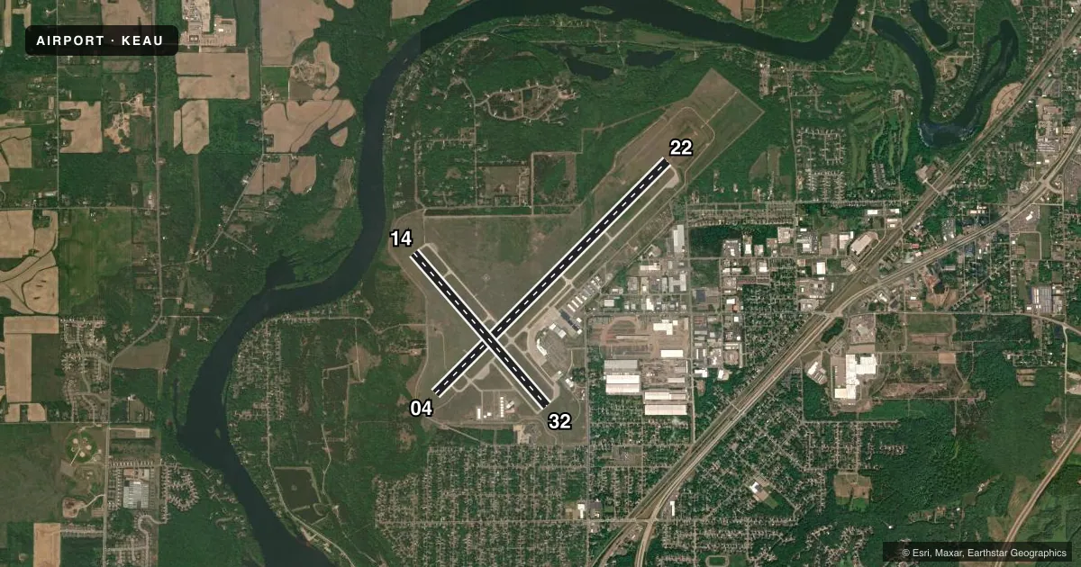
Runways & pattern
Full pagePattern entry · RWY 32
LEFT TRAFFIC| Runway | Heading (°M) | Length | Surface | Traffic |
|---|---|---|---|---|
| 04/22 | 44° / 224° | 8,101 ft | CONC | Standard L |
| 14/32Favored | 138° / 318° | 5,000 ft | CONC | Standard L |
Runway end performance
| End | TORA | TODA | ASDA | LDA | VGSI | Approach lights | Obstruction |
|---|---|---|---|---|---|---|---|
| 04 | 8,101' | 8,101' | 8,101' | 7,701' | PAPI 4-box left(3°) | — | 4', road, 140' from thr, 481' R of cntrln, slope 0 |
| 22 | 8,101' | 8,101' | 7,301' | 7,301' | PAPI 4-box left(3°) | MALSR | — |
| 14 | 5,000' | 5,000' | 5,000' | 5,000' | PAPI 4-box left(3°) | — | — |
| 32 | 5,000' | 5,000' | 5,000' | 5,000' | PAPI 4-box left(4°) | — | — |
Declared distances in feet. TORA = takeoff run available, TODA = takeoff distance, ASDA = accelerate-stop, LDA = landing distance.
Airport sketch
Runways drawn to scale from FAA survey coordinates, rendered over satellite imagery. Not for navigation.
Approaches & charts
ILS · 1
Services on the field
Fuel grades, oxygen, maintenance, ramp storage and lighting — as declared to the FAA by the airport operator.
Fuel & services
- Fuel
- 100LLA
- Oxygen (bottled)
- Low pressure
- Airframe repair
- Major
- Power plant repair
- Major
- Other services
- AFRT,AMB,CHTR,INSTR,RNTL,SALES
Ramp & ground
- Transient storage
- Tie-down
- Hangar
- Landing fee
- No fee published
- Customs
- Not available
- Lighting schedule
- SEE RMK
- Beacon schedule
- SS-SR
- Beacon
- White / Green (civil land)(WG)
- Wind indicator
- Lighted
- Segmented circle
- Yes
Fuel & FBOs
Cheapest 100LL and Jet A on the field and nearby. Always confirm with the FBO before taxi.
Airport notes
Surface conditions, obstructions, local procedures, lighting outages and other notes published with each FAA cycle.
General notes
- ARPT CONDS UNMON 2200 - 0500.
- DEER & BIRDS ON & INVOF ARPT.
- FOR CD IF UNA TO CTC ON FSS FREQ, CTC MINNEAPOLIS ARTCC AT 651-463-5588.
- ALL GA ACFT PARK AT FBO.
Lighting notes
- WHEN ATCT CLSD HIRL RY 04/22 PRESET ON LOW INTST; TO INCR INTST & ACTVT MALSR RY 22; REIL RWY 4; HIRL RY 04/22; REIL RY 14; PAPI RYS 14 /32; MIRL RY 14/32 - CTAF.
Runway surface & condition
- 04/22PCR VALUE: 420/R/C/W/T
- 14/32PCR VALUE: 190/R/C/W/T
Approach & departure obstructions
- 04ROAD 140 FT FM RWY END 481 FT LEFT OF CNTRLN.
- 04PAPI RWY 04 22 OPR CONSLY.
- 04APCH RATIO 50:1 AT DTHR.
Other notes
- ARFF NOT AVBL 24 HRS. PPR FOR UNSCHEDULED ACR OPNS WITH MORE THAN 9 PASSENGER SEATS; CONTACT ARPT MGR 715-839-6241. ACR OPNS WITH MORE THAN 9 PASSENGER SEATS NA IN EXCESS OF 15 MIN BEFORE OR AFTER SKED ARR/DEP TIMES WITHOUT PPR WITH ARPT MGR AND CONFIRMATION ARFF IS AVLB PRIOR TO LDG OR TKF.
- FBO SVCS AVBL ON 129.625.
- 1OTR ATNDNC TIMES CALL 715-839-4900.
- MANAGERADMIN@CHIPPEWAVALLEYAIRPORT.COM.
VFR map & nearby airports
VFR sectional. Tap any ICAO chip to open that airport.
Key facts · KEAU
Answer card- ICAO
- KEAU
- Name
- CHIPPEWA VALLEY RGNL
- Location
- EAU CLAIRE, WISCONSIN
- Elevation
- 913.1 ft MSL
- Traffic pattern altitude
- 1,913.1 ft MSL (1,000 AGL)
- Control tower
- Towered · 0530-2030
- Total runways
- 2
- Longest runway
- 04/22 · 8,101 ft
- Published ILS approaches
- 1
- Published frequencies
- 4
- Magnetic variation
- 1°
- Current flight rules
- VFR
- Current wind
- 320° at 12 kt
- Favored runway now
- RWY 32
Chippewa Valley Rgnl sits in Eau Claire, Wisconsin. Field elevation is 913.1 ft MSL. The airport has two concrete runways. The longest is 8,101 ft on 04/22. Runway 14/32 is 5,000 ft. The field is towered. Tower hours are 0530-2030. When the tower is closed, airport conditions are unmonitored from 2200 to 0500. Pattern altitude is not published. Use 1,000 ft AGL for light piston traffic unless local procedures say otherwise.
Runway 22 has the published ILS. That makes it the main instrument option to brief before arrival. The airport also has a busy lighting setup after hours. When the tower is closed, runway 04/22 lights come up at low intensity by default. Pilots can use CTAF to increase intensity and activate the approach lighting system and other runway lighting features. PAPI is published on runways 04 and 22 as a 24-hour aid. The published remarks also note a road near the runway 04 end. Treat the displaced threshold and departure path there with care.
Ascension FBO is on the field. It carries 100LL, Jet A and Jet A Prist. All general aviation aircraft park at the FBO. For larger unscheduled operations, prior permission is required. If you need clearance delivery and cannot raise flight service, contact Minneapolis ARTCC. Check the current FAA Chart Supplement for any noise or operational changes before you go.